HR: Iako na karti izgleda da je pokraj ceste za Križišce, do cachea se dolazi cestom kroz grad Hreljin prateci putokaze za Gradinu Hreljin.
Parkirati se možete na parkiralištu hreljinskog groblja sa kojeg se pruža prekrasan vidikovac prema otoku Krku.
EN:Although the map suggest it is on the road to Križišce, the cache should be reached by road through town Hreljin, following signs for Gradina Hreljin.
You can park in the parking lot of cemetery, which offers a wonderful view towards the island of Krk.
Povijest:
Kaštel Hreljin smješten je na iznimno povoljnoj strateškoj tocci koja je dominirala nad komunikacijama koje povezuju unutrašnjost Hrvatske preko Gorskoga kotara s morem i Bakarcem, u to vrijeme lukom Kaštela. Narodni naziv "Gradina" mogao bi ukazivati na parpovijesnu fazu, a pomišlja se i na to da je bio dio lanca rimskih fortifikacija "Septem turres".
Godine 1255. postaje posjed knezova Krckih, koji se od XV. st. nazivaju Frankopani. U Hreljinu je 1440. g. izdana glagoljska isprava kojom knez Ivan daruje zamlju pavlinima samostana Sv. Marije u Crikvenici. U XV. st. Hreljin je vece mjesto pa u njemu borave npr. i cetitri svecenika.
U XVI. i XVII. st. u posjedu je aristokratske obitelji Zrinski. U vrijeme provala Osmanlija prema Istri i Sloveniji znacajnija im je prepreka. nakon što je Bec pogubio zadnjega Zrinjskog, kaštelom upravlja austro-ugarska komora. Od 1778. pod upravom je susjednoga Bakra. Nakon izgradnje Karolinske ceste stanovništvo seli na obližnju lokaciju Piket. Godine 1789. ukinut je hreljinski kaptol, a nakon 1790. grad je napušten.
Tlocrt grada kojega omeduju nekadašnji bedemi, pokazuju nepravilnosti uvjetovane konfihuracijom tla. Najstariji dio grada - sam Kaštel - smješten je u JI dijelu. U nepravilnoj osnovi isticu se kvadratna i okrugla kula. Grad je imao južni i sjeverni ulaz. Uz unutrašnji plašt zidina izgradeni su stambeni i gospodarski objekti, sada urušeni. U centru naselja bila je crkva Sv. Jurja sa zvonikom - kulom na procelju. Izvorno je bila jednobrodna, a kasnije je proširena. Uz nju je kapela Sv. Marije iz XVII. st., i to na mjestu starije crkvice Sv. Stjepana. Nedaleko kapele je gradska cisterna.
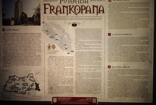
History:
The Hreljin Kastel is located at an extremely favorable strategic point that dominated the routers connecting the Croatian interior and the Gorski Kotar region with the sea and town of Bakarac beneath it, at the time the harbour of the castle. The popular name "Gradina"(hill fort) could indicate the prehistoric phase; It also assumed that this castle was a part of the chain of Roman fortifications, known as "Septem turres".
In the year 1255, Hreljin became property of the dukes of Krk, later known as the Frankopans. In 1440 a Glagolitic document was issued in Hreljin, by which Duke Ivan gave the land to Pauline Fathers from St. Mary's monastery in Crikvenica. In 15th century, Hreljin was a larger settlement with four priests.
In the 16th and 17th. centuries it was owned by the Zrinski noble family. During Ottoman incursions towards Istria and Slovenia, Hreljin castle represented a significant obstacles to them. After the last Zrinjski was executed in Vienna, the castle was administred by the Austro-Hungarian Chamber. From 1778th it was under the authority of the neighbouring town of Bakar. After construction of the Karoline Road, people moved to a nearby location Piket. In 1789th the Hreljin chapter was abolished, and after 1790th the town was abandoneded.
The layout of the town, enclosed by the former town walls, shows certain irregularities, which is due to the configuration od the terrain. The oldest part - the castle itself - is located in the SE part of the town. The irregular ground plan features a square and circular towers. The town had a south and the north entrance. Housing facilities and domestic offices, constructed along the inner mantle of the town wall, are now ruined. In the centre of the settlement was a church of St. George, with bell fry - tower on the facadw. Originally it had one nave, but later it was extended. Next to it is the chapel of St. Mary from 17th century, built on the spot of the earlier church of St. Stephen. Close to the chapel is the town cistern.