 This cave is located down a fairly easy hike from pull out parking
on Ou Kaapse Weg. The parking is easy to see from the road, but
I've given you a waypoint. Remember to not leave any valuables in
your car. It is reasonably safe here, but windows do get smashed
from time to time. At the trail head you will see a sign for Peers'
Cave. The trail is about a kilometer long and is mostly flat, but
does have some boulders on the way. GPS accuracy at GZ is bad, but
you can't miss the spot. You are looking for a large rock shelter,
not a little hidden container. The UCT archaeology department
brings first year students here for a practical. This cache is
partly an adaptation of that assignment. The dificulty rating of
this cache reflects the dificulty of these questions.
This cave is located down a fairly easy hike from pull out parking
on Ou Kaapse Weg. The parking is easy to see from the road, but
I've given you a waypoint. Remember to not leave any valuables in
your car. It is reasonably safe here, but windows do get smashed
from time to time. At the trail head you will see a sign for Peers'
Cave. The trail is about a kilometer long and is mostly flat, but
does have some boulders on the way. GPS accuracy at GZ is bad, but
you can't miss the spot. You are looking for a large rock shelter,
not a little hidden container. The UCT archaeology department
brings first year students here for a practical. This cache is
partly an adaptation of that assignment. The dificulty rating of
this cache reflects the dificulty of these questions.
Today, the cave is named after the local
excavators who dug most of the cave, a father and son team named
Victor and Bertie Peers. It is also known as Skildergat, or
Skildegat. This name may be derived from the rock paintings in the
shelter (Afrikaans Skilerye + gat or painted hole/cave).
Although faint, and often covered by graffiti, these are the only
old rock paintings within 100 km radius of Cape Point. The cave may
also be named after a farm hand named Schilder who used the cave as
shelter for cattle in the 1800s (Schilder's kop).
Geology Lesson: Deposition, Sediment Traps, and
Stratigraphy:
The geology lesson I'd like to teach at this
site is about deposition and stratigraphy. My father asked me a
simple but important question when I first started studying
archaeology. He noticed that archaeologists were always digging
things up. This led him to wonder three related questions:
- Where does all that dirt come from?
- If it keeps burying archaeological sites, does the planet just
keep getting bigger over time?
- Why did people a long time ago spend so much time in caves,
wasn't it nice outside?
I'm going to tell you the answers to two and
three, the answer to question one is what you will need to figure
out. It isn't from meteorites; that was his first guess.
The answer to number two, as any geologist can
tell you, is no; the earth isn't getting bigger. Erosion removes
sediment (dirt) from one place, either by wind or water, and leaves
it behind, deposits it, somewhere else. By this method, dirt moves
from one place to another, exposing some things once buried, and
burying other things once exposed.
The answer to number three is related to this
process as well. Archaeologists dig where we are likely to find
stuff from the past. These places are not necessarily the places
where people hung out the most, but are places where dirt has
accumulated. Places that collect dirt (sediment traps) also bury
evidence from the past. In other words, the reason archaeologists
dig up caves is not because people in the past only hung out
in caves. Rather we like caves, because caves can trap sediment,
and keep it dry and safe.
A friend of mine published a paper about why the
area where he works in Iran has caves with deposits on one side of
the valley, and the opposite side of the valley all the caves were
all empty (Heydari, 2007). His explanation was important for
interpreting how people lived in the past. He showed that the
absence of evidence was due to geological causes, and not due the
behaviour of people. I bring it up here because it is helpful for
understanding sediment traps. In many earthcaches you've learned
about bedding planes. Sedimentary rocks (like the Table Mountain
Sandstone here) form in layers. These layers typically are bedded
at an angle (their dip and strike), usually due to movement of the
rocks forming mountains. The following illustration comes directly
from his paper.
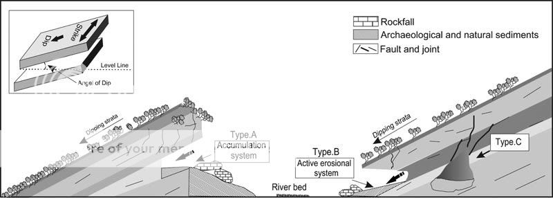
Don't worry too much about understanding
everything here. The main thing I want you to get is that because
of the way 'Type A' sites are angled in the bedrock, they collect
sediment like a bucket. Because of the way 'Type B' sites are
angled, they don't collect sediment very well at all, much like a
tipped over bucket. Peers' Cave is more or less a 'Type A' site. A
good example of a nearby 'Type B' site would be
Elephant's Eye Cave. For those of you who've been there, you
know it slopes steeply down and out of the cave. The fact that we
don't have evidence of people living there is not because they
didn't, it is because the shape of the cave didn't allow any
sediment to accumulate, and thereby leave behind evidence. Although
this may seem simple and abundantly obvious, all good science does
once it is pointed out and explained.
Sediment traps, such as caves, are great for
archaeology because there are many different periods of deposition
that create different identifiable layers. Much of how we are able
to know the age of something is due to its position in this
sequence of layers. Understanding the sequence and process of
deposition by looking at these layers is called stratigraphy and is
exactly the same in Geology. In fact, archaeologists stole the
method from geologists. Archaeologists, like geologists,
reconstruct the sequence in which sediment was deposited by looking
at a cross section of layers, called a profile.
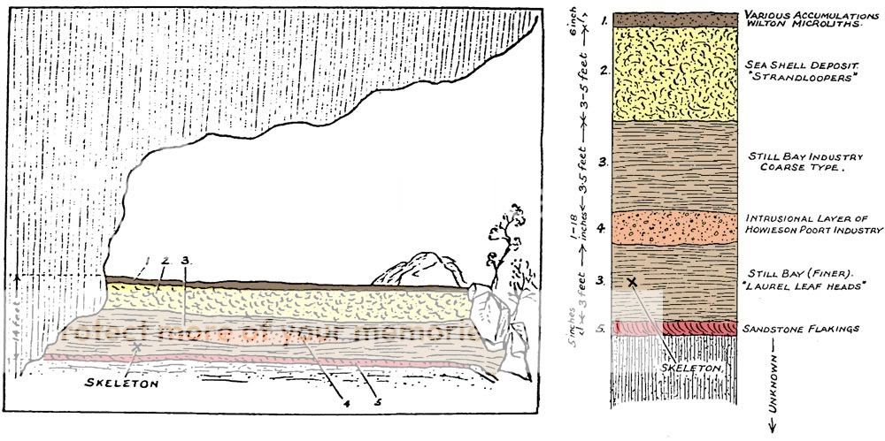
Here is a drawing of the cross-section of the
cave that was published in 1931 (I added colours to make it
clearer). You can see the sediment inside the 'bucket' of the rock
shelter. In the above diagram, layer 3, that contained the
skeleton, must be older than layer 2, because 2 is on top of it. It
must also be younger than layer 5, because 5 is beneath it. This is
called the "Law of
Superposition" which is just a fancy way of saying that the
stuff on top got there later than the stuff under it.
The surface of the sediment in the cave before
it was excavated can be seen on the rock wall when you vist. The
deepest parts were dug over six meters below this original level.
The Peers found nine human skeletons in this shelter. One of them
became famous as the 'Fish Hoek Man', as it came from a layer that
contained very old stone tools. The skeleton (its position is
labeled in the drawing) is often mentioned in histories of the area
as being 12,000 years old. This turns out not to be true, and I
will tell you more below.
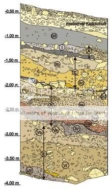 The
Peers did not dig in a way that today we would consider to be
careful. They used shovels, picks and dynamite, and as a result,
the layers they identified are very simple. To anyone who has
worked in caves, this is clear from their drawing above; it is way
too simple. Their column represents about 14 feet of depth (just
over 4 meters), and only identifies five layers. There is another
(big) problem with this drawing, but identifying it will be one of
your questions. Sediment traps, such as this rock shelter, create
very complicated series of layers. Once you add people living
there, making fires and digging holes, things get even more
complicated. Understanding these layers, and knowing what came out
of each of them, is what archaeologists (and geologists) do to
understand the past formation of rocks and sediment. On the left is
an example of cave stratigraphy. It comes from the cave site of
Hohle Fels in
Germany. This is what a cross section of a cave should look
like. Really, really complicated.
The
Peers did not dig in a way that today we would consider to be
careful. They used shovels, picks and dynamite, and as a result,
the layers they identified are very simple. To anyone who has
worked in caves, this is clear from their drawing above; it is way
too simple. Their column represents about 14 feet of depth (just
over 4 meters), and only identifies five layers. There is another
(big) problem with this drawing, but identifying it will be one of
your questions. Sediment traps, such as this rock shelter, create
very complicated series of layers. Once you add people living
there, making fires and digging holes, things get even more
complicated. Understanding these layers, and knowing what came out
of each of them, is what archaeologists (and geologists) do to
understand the past formation of rocks and sediment. On the left is
an example of cave stratigraphy. It comes from the cave site of
Hohle Fels in
Germany. This is what a cross section of a cave should look
like. Really, really complicated.
Zambesiboy, in his answers, pointed out another
interesting aspect of sediment traps. They trap the fine sediment
(silt and clay) that gets blown away in other parts of the
landscape. As a result, the soil in shelters is very rich. Or as he
put it: "It actually looks quite good for the garden". Many of the
archaeologically rich caves in South Africa were destroyed by
farmers with this exact thought before there were laws to protect
them. The first of these laws was enacted in 1911, a 100 years ago.
So, please don't go collecting sediment from here, you would not
only destroy valuable information, you'd also be breaking the
law.
Peers' Cave is not a proper cave, but a rock
shelter formed in the Ordovician aged Table Mountain Sandstone that
makes up this rock outcrop. The shelter was formed by the
weathering of less resistant rock along the outcrop, with more
resistant rock above it forming the roof. It faces south across the
Fish Hoek/Noordhoek valley which is covered by shifting sand
dunes.
The sea levels have changed a fair amount in the
past. The last time the valley floor was under water was the late
Miocene or early Pliocene, about 5 million years ago. It was during
this time that a great deal of sand was deposited. Today this sand
forms the dune fields you can see across the valley floor. However,
for most of the time people were living here, sea level was much
lower than it is today, about 40-120 meters lower. This was because
much of the planet's water was in glaciers in the northern
hemisphere. The lowered sea level caused the sea shore to be much
farther away than it is now.
At this point, along with your keen
observational skills, I've given you everything you need to answer
your questions. But first let me tell you a little bit about why
the site is interesting and what was found in the dirt that got
trapped here.
A little information about the archaeology:
This cave contains traces of humans living here
as long ago as 200,000 years ago. Much of the excavation here was
done by the Peers and John Goodwin in 1925-1931. As both the Peers
had full time jobs, work was limited to weekends, public holidays,
and their annual leave. Field Marshal Smuts declared in 1932 that
the cave "promises to be the most remarkable cave site yet found in
South Africa". Keith Jolly dug here in 1946-1947, and Barbra
Anthony in 1963. Recent work was done by a joint South African and
American team in 2002, investigating what was left of the deposit.
Unfortunately, most of the sediment was removed by the Peers.
Nonetheless, we know that the majority of the
sediment in the cave contained Middle Stone Age tools of types
dated to around 70,000-60,000 years ago. The Middle Stone Age is a
major focus of global research today, as it was during this period
that anatomically modern humans (people like us) first appeared.
The upper portions of the cave have evidence of more recent people,
from within the last 10,000 years. Their tools were different, as
they hunted smaller game, collected shellfish and fish, and
gathered plant food. By 2000 years ago the people living in this
valley were herders of domesticated sheep. There were also some
finds that are likely from the historic period. Jan van Riebeeck
noted in his diary that indigenous people were living in this
valley in the 1650s, and his interpreter 'Harry' spent time here,
perhaps even in this cave.
Even at the time when the 'Fish Hoek Man' was
excavated, there were doubts about its age. The preservation of
this skeleton did not match the other animal bones found in the
same layer. These were very fragmentary compared to the fairly
intact human skeleton. Unfortunately, once something has been dug
up, you can never recreate its position in the layers. Excellent
notes and careful excavation are the only way to dig correctly, as
there is only one chance to get it right. However, bone can be
dated directly using the method of carbon 14 dating. Eventually,
this question was addressed by a group of Cape Town scientists
(Stynder et al, 2009). They dated the skeleton directly, and
determined it to be just over 7000 years old. Even though it is
much younger than previously thought, it is still one of the oldest
skeletons found in the region.
Questions to answer:
- What effect do you think the presence of the large rocks at the
front of the cave had on the archaeological deposits?
- Given the "Law of Superposition", explain why Layer 4 in the
above depiction of the cave's stratigraphy is a problem. (you do
not need to google the cultures mentioned or understand the
archaeology, this is only a question of thinking about the
deposition of these layers logically)
- How do you think the sediment in the cave got here (by what
methods)?
- Where did it come from?
- Look at the sediment in the cave carefully. What colour is it?
What texture does it have? Is this the same as its source? If not,
what do you think caused it to be this colour?
- OPTIONAL: A photo of you and your GPS at the site in your log
is always fun.
References consulted:
Deacon,
J., Wilson, M., 1992. Peers Cave: the "Cave the World Forgot.".
The Digging Stick 9: 2–5. (link)
Heydari,
S., 2007. The impact of geology and geomorphology on cave and
rockshelter archaeological site formation, preservation, and
distribution in the Zagros mountains of Iran. Geoarchaeology
22: 653-669 (link)
Keith,
A., 1931. New discoveries relating to the antiquity of man,
Williams & Norgate LTD, London. (link)
Stynder,
D.D., Brock, F., Sealy, J.C., Wurz, S., Morris, A.G., Volman, T.P.,
2009. A mid-Holocene AMS 14C date for the presumed upper
Pleistocene human skeleton from Peers Cave, South Africa,
Journal of Human Evolution 56, 431-434.

Free counters
 |
 |
FTF goes to MnCo & Zambesiboy! |
 |
|
|