You can click to enlarge images on this page.
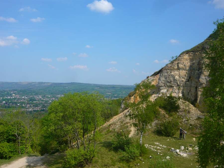
Leckhampton Hill – a Jurassic park
The rocky strata of Leckhampton Hill were deposited as sediment in warm seas during the Middle Jurassic period, some 165-175 million years ago. Today they can be seen exposed in the quarries on and under Leckhampton Hill as a thick series of limestones spanning the whole of the Birdlip Limestone Formation and beyond. Such complete exposure of a series of rock strata is rare, with several sites on Leckhampton Hill declared to be of national importance for Jurassic stratigraphy as a result.
The image below shows the lithostratigraphy (rock layering) of Leckhampton Hill. In this earthcache, we will explore two sites in particular – Dead Man's Quarry and Lower Limekilns Quarry – that between them expose almost the full range of strata.

Access
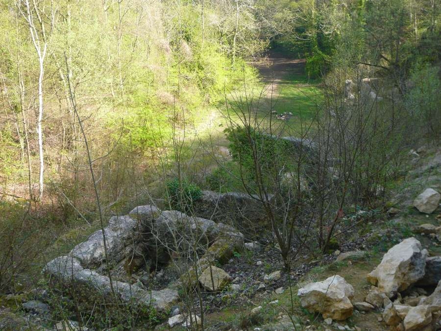
From Daisybank car park, venture into the woods via the information boards to find the wide path climbing up to your right. (This was formerly the standard gauge railway connecting the works on the hill with the depot at Southfield Farm.) Follow this to Lower Limekilns Quarry. To continue on to Dead Man's Quarry, join the steep rocky path at N 51° 51.933 W 002° 04.562.
From Salterley car park, follow the Cotswold Way up over the hill to the Cotswold Way / Devil's Chimney signpost. Take whichever option you like en route to Dead Man's Quarry: either CW for the toposcope (then down to the quarry), or DC for a view over that landmark (then right to the quarry). To continue on to Lower Limekilns, leave Dead Man's Quarry via the steep rocky path at N 51° 51.888 W 002° 04.680.
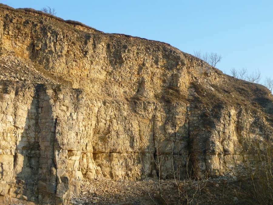
Dead Man's Quarry

A well-known landmark for its golden glow in the evening sun and for the occasional quirky message laid out in stone on the quarry floor, Dead Man's Quarry was once an major source of stone for building and lime-burning, and was worked extensively. It is now one of the most important locations in the Leckhampton Hill SSSI.
At least four lithostratigraphic members (clearly defined layers of rock) or beds (subdivision of a member) are visible at Dead Man's Quarry. From the top down:
- Aston Limestone Formation – Lower Trigonia Grit Member. Up to 6ft of yellowish-brown and rubbly limestone. This is visible only from higher up, not from the quarry floor. The division between this and the Scottsquar Member below is a disconformity (animation) owing to the absence of the Harford Member of the Birdlip Limestone Formation, probably due to this part of the Cotswolds being above sea level during the period in which the Harford Member was deposited ten miles or so to the east.
- Birdlip Limestone Formation – Scottsquar Member – Upper Freestone. Up to 30ft of massive pale grey packstones/grainstones (Dunham classification), formerly quarried for lime burning.
- Birdlip Limestone Formation – Scottsquar Member – Oolite Marl. Up to 10ft of cream coloured soft muddy limestone, formerly quarried for lime burning. Geologist notes record "beautifully preserved fossils", though there are few if any safe places to see this for yourself in Dead Man's Quarry.
- Birdlip Limestone Formation – Cleeve Cloud Member – Lower Freestone. Up to 40ft in places of massive pale grey to yellowish-buff limestone. Quarried for building (not just lime-burning). When freshly mined it is easily cut by the saw, but it hardens on exposure.
To enjoy a vertigo-inducing view of these strata, consider standing a while at N 51° 51.864 W 002° 04.652, then visiting the nearby toposcope, before heading down to study the geological features up close.
From down on the quarry floor, one can observe geological features associated with both the Jurassic formation of the limestone and with its much later (Ice Age) subsidence:
| • |
Formation |
|
|
Oolitic limestone. The fine-grained Lower Freestone is oolitic, originating in the movement of tiny spherical grains of calcium carbonate, called ooids, over the sea floor. Ooids are formed by accretion of carbonates around a nucleus of some kind, perhaps a sand grain or a shell fragment, and tend to be around 1mm diameter (cf. the larger oncoids encountered in Pea Grit). When buried under additional sediment, these ooid grains cemented together to form limestone. |
 |
|
Cross-bedding. Ooids react to currents in the same way that sand grains in a desert react to wind: they are transported in a prominent direction and form mounds (dunes). The ooids are driven up the dunes and roll down the lee side where they are deposited, forming angular beds. In Dead Man's quarry, we see cross-bedding at a downhill angle from left to right (as one faces the rock), indicating the sea currents flowed to the right during this period of deposition. |
 |
|
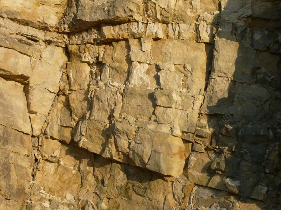
Hardgrounds. Taking a view across the whole quarry face, one can see a continuous horizontal line (division between rock layers) stretching end-to-end. This is a hardground, formed as the result of erosion taking place during a period of sediment deposition: the top part of the already hardened sequence was removed by water-current action before deposition resumed and more rock formed above it. In the middle of the quarry face, at ground level, a section of another hardground is visible. Muddy sand coats the surface, this being what little was deposited in the fast-flowing currents. |
 |
|
| • |
Subsidence |
 |
|
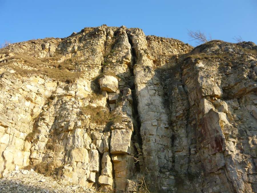
Gulls. These large fissures arose from rigid limestone cracking as the whole mass of hard rock subsided on the soft Lias Group Clays beneath, and the cracks widening as the rock slid slowly downhill. Meanwhile, the soft clays simply bulged outwards. Much of this movement occurred at the end of the last Ice Age when the permafrost thawed out. Behind one of the gulls (pictured), at about the level of the Oolite Marl, is a cave reaching some 20m into the hillside. |
Dead Man's Quarry to Lower Limekilns Quarry
A steep rocky path leaves Dead Man's Quarry at N 51° 51.888 W 002° 04.680 and drops 10m or so to the north before levelling out. This bank down which this path runs is the result of a normal fault (animation) stretching in an E-W direction across the escarpment. The cliff face is markedly disturbed, with layers of rock out of sequence, around here.
The fault causes a weakness in the rocks either side of it, making them erode more readily. The actual fault is buried beneath the scree resulting from this erosion and essentially is the slope of the hillside where it drops away. At the bottom of the bank, you are standing on the same rocks (same stratigraphical position) as you were on the floor of Dead Man's Quarry, with the slope you have just walked down being the "throw" of the fault.
There is a large dislocated block of limestone at the lower end of the fault, adjacent to the path, with rivers of scree spilling down either side of it. This is probably the result of a smaller fault joining at an angle to the main one, in effect cutting a chunk out of the rock face where the faults intersect.
Lower Limekilns Quarry
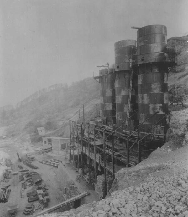
Photograph from the collection of David Bick. Used with permission.
Lower Limekilns was a small quarry until the introduction, in the 1920s, of four tall steel limekilns. The nominal combined output of lime for the four kilns was 300 tons per day but this was never reached. The design was new and did not work very well and failed to produce lime of a consistent quality. Today only the concrete bases remain.
A rocky ramp leads gently up from the ruins of the electrical plant house, alongside the quarry face, to just above the bases of the limekilns. Climbing the ramp, to the left one sees the rock divides fairly evenly into three layers. From the top down:
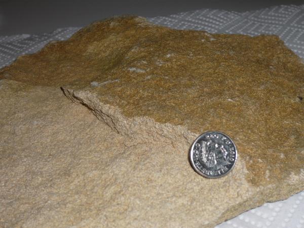
- Crickley Limestone Member – Pea Grit. Up to 10ft of yellowish-buff rubbly limestone containing pea-sized oncolites, formed from the accretion of carbonates and blue-green algae around a nucleus, and the occasional larger fossil. Formerly quarried for gate-posts and other rough work. A few chunks of Pea Grit can typically be seen fallen to the ground or, for the adventurous, intact sections can be inspected at head height at the top of the gently-sloping ramp above the limekiln bases.
- Crickley Limestone Member – Lower Limestone. Up to 9ft of brown/yellow/grey limestone. It is bioclastic, containing tiny shell fragments, unlike the smoother (and more prized for building) oolitic rock found in Dead Man's Quarry. Lower Limestone is brittle and very blocky in comparison to the layers above and below: open cracks ("joints") between the blocks are likely to be due to cambering (see below) and pressure release following quarrying.
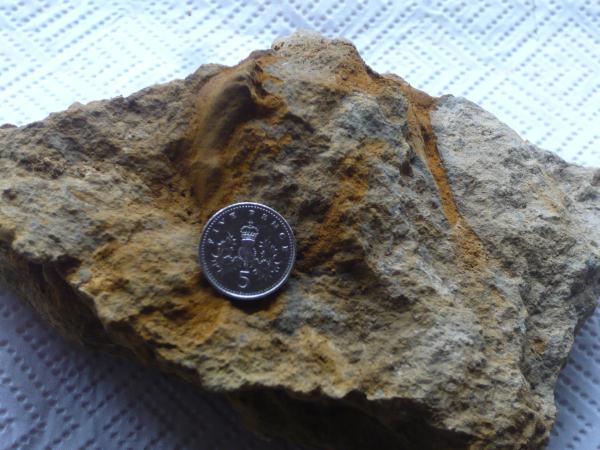
- Leckhampton Limestone Member – Scissum Beds. Up to 10ft of yellowish to orange-brown, rubbly/marly limestone. Stains orange when handled. On closer inspection, one often finds darker orange channels in the limestone, usually no more than an inch or two in length, that are the bore-tubes of grazing animals on the (then) soft sea floor.
To get a proper appreciation for these rocks it is important to look at recently fallen samples in addition to the main rock face. For example, the vivid orange of the Scissum Beds layer comes from an orangey marl which, when cleaned off a fallen sample, reveals a hard greyish-orange rock underneath and highlights any fossilised tracks. Similarly, the dull colour of weathered Lower Limestone is in marked contrast to the lighter yellow stone revealed by a fresh break; and on the unweathered surface one can easily see the shell fragments of which the Lower Limestone is comprised. Some examples are shown below (from the left: Pea Grit, Lower Limestone, Scissum Beds) – click on any of them for a larger version.


There are several other geological and historical features of interest at Lower Limekilns Quarry, including:
| • |
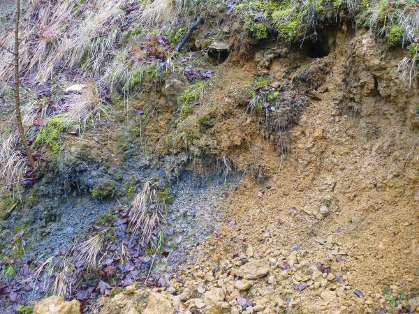
Whitby Mudstone. The appearance of this blue-grey clay in the orangey Scissum Beds is at first quite surprising. Whitby Mudstone is a formation of the Lias (rhymes with "bias") Group whose clays, as indicated above (see: gulls), can be pinched, bulge and swell depending on where pressure is exerted on them. The patch of Whitby Mudstone seen in Lower Limekilns Quarry is probably right on the edge of the overlying mass of limestone, and had been squeezed out during subsidence. |
 |
| • |
Cambering. Also known as gravitational spreading or gravity faulting, this is the process whereby an overlying slab of rock, affected by a network of joints (like cracks in dried mud), moves slowly down and outwards across the soft clays beneath. The photo shows a part of Lower Limekilns Quarry that tilts out slightly towards the ruins of the electrical plant house, although the tilting effect is far from clear at this angle. Movement is very slow – probably millimetres (or less) per year. |
 |
| • |
Remains of the 1920s limekilns. The job of the limekilns was to burn limestone (composed of calcium carbonate) to produce quicklime (calcium oxide). In symbols: CaCO3 + heat → CaO + CO2 . When treated with water, this produces slaked lime (calcium hydroxide), which has a number of applications in agriculture, to break down heavy clay soils, and in the building industry, for example when mixed with sand to form mortar. |
 |
To claim a "find" on this earthcache
To validate your geocaching smiley, you'll need to contact me through my profile (here) with answers to three Earth Science tasks. You don't need to wait for me to reply before logging the find.
- Walk up the quarry, carefully, to any safe position just above the gull shown on this cache page.
Take a GPS reading: what are the coordinates?
- At the bottom of the fault between Dead Man's Quarry and Lower Limekilns Quarry, you'll see a large dislocated block of limestone.
How tall is it (to the nearest metre or so)?
- Examine one of the largest rocks fallen to the ground at the top of the gently-sloping ramp (path by the rock face) in Lower Limekilns Quarry.
Describe its size and granular texture; what type of rock is it?
While you're here, do please take the time to wander a bit and admire the views. Besides the toposcope on top of Dead Man's Quarry, there are also some very well situated benches at quarry floor level on the edge of the hill. Photos would be much appreciated!
I hope you have enjoyed exploring the Jurassic history of Leckhampton Hill 
References
The following internet resources were useful for the compilation of this earthcache, and may be of interest to visitors wanting further information:
- [html] Cotswolds Geology. Gloucestershire Geology Trust (2008). link verified 01 Dec 2015
- [html] Leckhampton Hill Rural Geology Trail. Gloucestershire Uncovered series leaflet. Gloucestershire Geology Trust (2004). link verified 01 Dec 2015
- [pdf] Generalised Stratigraphy of Gloucestershire and Representative Sites. Gloucestershire Geology Trust (2009). link verified 01 Dec 2015
- [html] Leckhampton Hill, Gloucestershire. British Middle Jurassic Stratigraphy (2002), B.M. Cox & M.G. Sumbler, Geological Conservation Review Volume: 26, Chapter: 3. link verified 01 Dec 2015
- [pdf] Landslip Caves of the Middle Cotswolds. C.A. Self and A.Boycott. Proceedings of the University of Bristol Spelæological Society, 2004, 23(2), 97-117. link verified 01 Dec 2015
- [pdf] The Industrial Archaeology of Leckhampton Hill. Ray Wilson, Gloucestershire Society for Industrial Archaeology Journal (2001). link verified 01 Dec 2015
- [pdf] Leckhampton Hill and Charlton Kings Common Management Plan, Issue 2, April 2003. link verified 01 Dec 2015