The Blue Hole
The Blue Hole of Belize is part of the Lighthouse Reef System, it lies approximately 60 miles off the mainland out of Belize City. It is one of the most astounding sites to be found anywhere on earth!
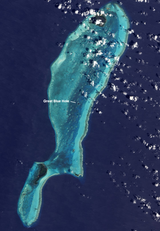
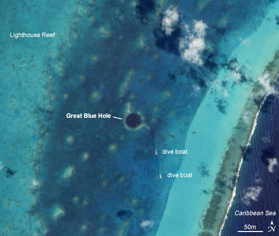
Right in the center of Lighthouse Reef is a large, almost perfectly circular hole approximately one quarter of a mile (0,4 km) across. Inside this hole the water is 480 feet (145 m) deep and it is the depth of water which gives the deep blue color that causes such structures throughout the world to be known as "blue holes."
The Lighthouse Reef atoll is the furthest from the shore, at around 60 miles off. The reef structures start at around 30 feet depth. In the middle of this reef there is the Blue Hole.
The cave system that survives houses some stalactites some of which are as large as 40 inches long and 10 inches wide. These caves are believed to have been flooded during the last Ice Age.
The Blue Hole is a "karst-eroded sinkhole." It was once a cave at the center of an underground tunnel complex whose ceiling collapsed. Some of the tunnels are thought to be linked right through to the mainland, though this has never been conclusively proved. The mainland itself has many water-filled sinkholes that are connected to caves tunnels.
At some time many millions of years ago, two distinct events occurred. First, there was a major earthquake and this probably caused the cave ceiling to collapse forming the sinkhole. The upheaval, however, had the effect of tilting Lighthouse Reef to an angle of around 12 degrees. All along the walls of this former cavern are overhangs and ledges, housing pleistocene stalactites, stalagmites and columns.
Some of the stalactites now hang at an angle, yet we know they cannot develop at any angle other than perfectly perpendicular. In addition, there are those stalactites which were formed after the earthquake and others which were formed both before and after that cataclysmic event-the top of the stalactite being at an angle and the bottom being perpendicular. At that time the sea levels were much lower than today and the second major event was to change all this. At the end of the Great Ice Age the glaciers melted and sea levels throughout the world rose considerably. This process occurred in stages. Evidence for this are the shelves and ledges, carved into the limestone by the sea, which run the complete interior circumference of the Blue Hole at various depths.
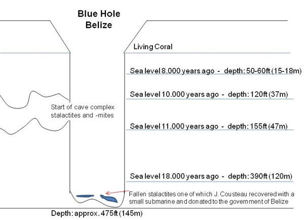
The first of these ledges is found between 150 and 165 feet (45-50 m) and is best visited on the south side. The base of the ledge is perfectly flat and cuts back into the rock some 15 to 20 feet (5-6 m). This creates an ever-narrowing cavern until the roof reaches the floor right at the back. Here in the V-shaped ledges, cut into solid limestone, are stalactites, stalagmites and columns (where stalactites and stalagmites have joined) which do not exist in the shallower waters of the Blue Hole.
Half Moon Caye National Monument
Located at on the southeast corner of Lighthouse Reef Atoll, the easternmost of Belize’s three atolls, Half Moon Caye National Monument was the first nature reserve to be established under the National Parks System Act of 1981.
Managed by the Belize Audubon Society, this 44 acre island reserve is a nesting ground for the red-footed booby and a greatcampsite or picnic location between dives off the nearby atolls.
The waters surrounding Half Moon Caye have abundant marine life with the Blue Hole just minutes away.
Here it comes now!
You actually made it!
Now, please fulfill an easy task!!
1. Have a stroll and read the information given by the signs along the way. Please let us know which natural force is reshaping the island?
2. When you reach the observation platform have a look around. There are two signs explain what you will be able to watch – what is it?
Please send your answers with the contact possibility in our profile.
It would be really nice if you would enclose a picture of yourself and your GPS with your log! Maybe in front of the red “sharky” wall? :-) (OPTIONAL)
Have a wonderful time on this magical island!
The terrain rating applies to the inaccessibility of the island! There is no other way than by boat and it is quite a bit out of the way - unless of course you are a keen diver :-)