[ENGLISH]
The lowest freshwater lake on earth
The Sea of Galilee is because of it's "hight" -212m among sea level the lowest fresh water lake on earth. After the Dead Sea (-400m among sea level) (which ist not fresh water) it is the second lowest stagnant water on earth.
This special situation is caused by the fact, that the Sea of Galilee, the Jordan Valley and also the Dead Sea is placed in an geomorphological low ground. A geomophological low ground, with dry land among sea level is called depression.
Definition of Depression:
Depression in geology is a landform sunken or depressed below the surrounding area. Depressions may be formed by various mechanisms, and may be referred to by a variety of technical terms such as:
- Basin: any large sediment filled depression. In tectonics, it may refer specifically to a circular, syncline-like depression: a geologic basin; while in sedimentology, it may refer to an area thickly filled with sediment: sedimentary basin.
- Blowout: a depression created by wind erosion typically in either a desert sand or dry soil (such as a post-glacial loess environment).
- Graben: a down dropped and typically linear depression or basin created by rifting in a region under tensional tectonic forces.
- Impact crater: a depression created by an impact such as a meteorite crater.
- Kettle: a shallow, sediment-filled body of water formed by retreating glaciers or draining floodwaters.
- Oceanic trench: a deep depression with steep sides located in the ocean floor. Oceanic trenches are caused by the subduction (when one tectonic plate is pushed underneath another) of oceanic crust beneath either other oceanic crust or continental crust.
- Pit crater: a depression formed by a sinking, or caving in, of the ground surface lying over a void.
Valley: a type of depression usually carved by erosion.
(authority: wikipedia.org)
Here in this area you'll find a pull apart basin. This is a type of structural basin which is developed between two offset segments or at a flexure in a strike-slip fault or a transform fault. A pull-apart develops where the sense of offset leads to extension, either at a right-stepping offset on a dextral sense fault or a left-stepping offset on a sinistral fault. This geometry means that fault displacement will literally pull a section of crust apart and cause the extension. (authority: wikipedia.org)
Most major depressions are associated with tectonic plate boundaries. They form when converging plates deform or when spreading centers open. Most of these depressions are in the northern hemisphere for a good reason: this is where most of the land is and where most of the plate boundaries occur.
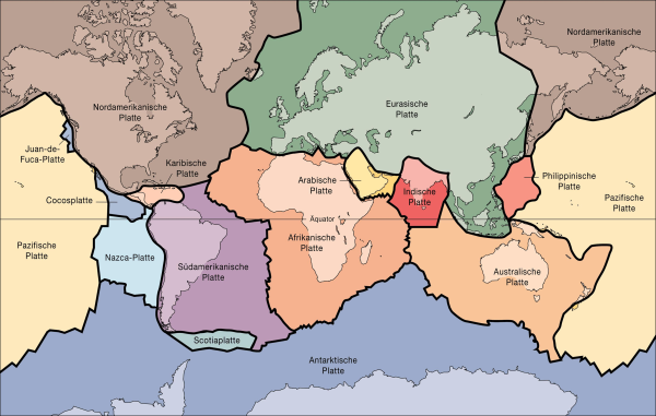
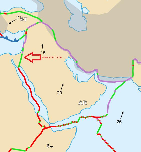
African und Arabian Plate
The Dead Sea, Jordan Valley and also the Sea of Galilee is located in a deep valley at the transform boundary between the African and Arabia Plates (shown on the map). The motions of the African and Arabian Plates, combined with the motion of shear-zone faulting has resulted in the formation of the deep Jordan Valley Depression.
Geological property at the Sea of Galilee
Due to strong tectonics hot springs leak out of the ground in different places. This hot springs were the reason, that the Sea of Galilee has been an recreation area from the antiquity.
There is an distingtion between two different kinds of spings. Springs to be high in calcium (this kind of spring you'll find in Tabgha) and spring to be high in magnesium (to be found in Fuliya, Tiberias, Gofra, Ha'On 1 and Hammat Gader).
The Hot Springs of Tabgha
are very different in salinity and temperature. This is caused by geological faults which extend very deep into the interior of the earth. 500m westwards the hollow of Rosh Pina meets the riverside road to Tiberias. There you can find the 2nd deep fault. The eastside of Tabgha is built of an basaltic block of Chorazim.
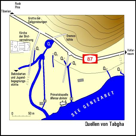
The groundwater descends mostly from the upper aquifer and distinguishes concerning chloride content (0,2 to 2,4 g/l) and temperature (19 bis 39 °C). The reason therefor is the mixture of ascending brine and salt free groundwater.
To illustrate that fact please see the below the map and the geological cross sections in the following figures.
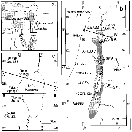
Map of the Dead Sea Rift Valley. The rectangular indicated in Figure 1a is enlarged in Figure 1b, and that in Figure 1b is enlarged in Figure 1c. The region depressed below sea level is shaded in Figure 1b. Locations of the saline hot springs and lines of two geological cross sections are shown.
The east-west cross sections illustrates the conceptual models suggested for the emergence of the saline hot water through springs at See Galilee (Lake Kinneret):
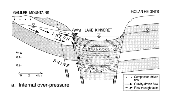
the “self-potential brine” model, according to which deep brines are overpressured due to compaction of sediments and/or tectonic movements;
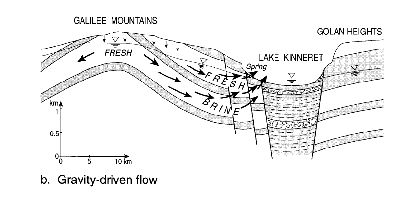
the “stagnant brine,” or “leaching,” model, according to which brines are pushed by the circulating meteoric groundwater;
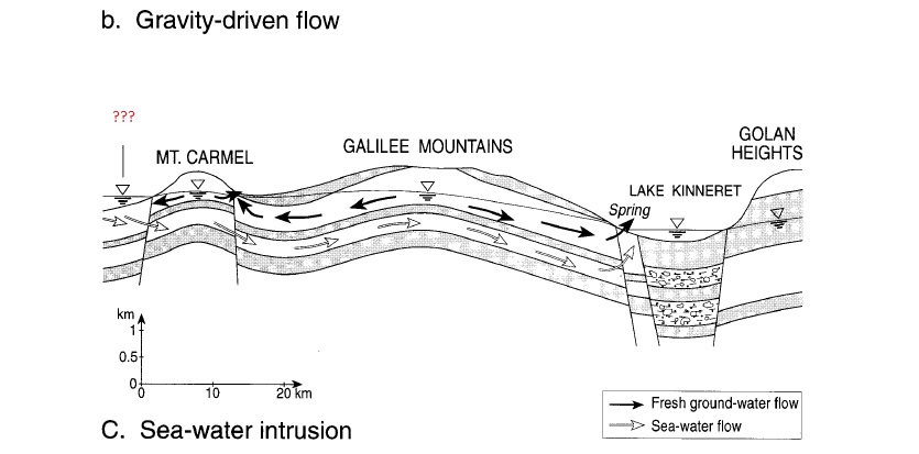
the “seawater intrusion” model, according to which the driving force is the 210-m difference between the Mediterranean Sea and the lake.
Figures were prepared on the basis of concepts suggested by Mazor and Mero [1969], Goldshmidt et al. [1967], and Kafri and Arad [1979], respectively.
Additional Information
For further details about the Tectonic plate please visit:
http://en.wikipedia.org/wiki/Tectonic_plate
To log this cache, please fulfill the following requirements:
1.) Measure or estimate the temperature of the water of the Sea of Galilee. Please explain in your own words why the temperature is higher (especially in wintertime) than you could expect.
2.) The springs of Tabgha are not only hot, they are salty too. Where does this salt water come from and why? .
3.) Optional: if you like you can attach a picture of yourself, the beautyful location or your GPS to the log. (This is not required to get the log permission)