From the guidelines: "People do not need to wait for permission to log your EarthCache. Requiring someone to wait is not supported by the EarthCache guidelines. People should send their logging task answers to you, then log your EarthCache. When you review their logging task answers, if there is a problem, you should contact them to resolve it. If there is no problem, then their log simply stands."

 Introduction
The title might seem strange but it reflects the amount of money that the municipality of Cascais is spending on the preservation of the Guincho-Oitavos Dune Field with the help of the National Strategic Reference Framework (NSRF) programme whose main strategic aim is the qualification of the Portuguese people through an emphasis on knowledge, science, technology and innovation, as well as the promotion of high and sustained levels of economic and socio-cultural development and territorial qualification within a framework of expanding equal opportunities and increasing the efficiency and quality of public institutions.
This is one rare occasion where money is actually being invested in geology (and a little bit of biology).
But why are these dunes important?
Due to the strong prevailing winds, NW-SE, in this region, the Guincho-Cresmina-Oitavos Dune Field is generated by sand sourced from the Cresmina and Guincho beaches. This sand returns to the sea a little further south after migrating over the rocky (Creaceous limestones) Cape Raso platform thereby giving rise to the local term: Aeolian corridor of the Cresmina-Oitavos Dune system.
Dune Formation in the Guincho-Oitavos Dune Field
Coastal dunes are accumulations of sand built up by the joint action of sea and wind. They are fragile but extremely important structures, as they protect the more inland areas from the encroachments of the sea. For more information see also: Wind Ripples - DP/EC 18 (GC1CZEE).
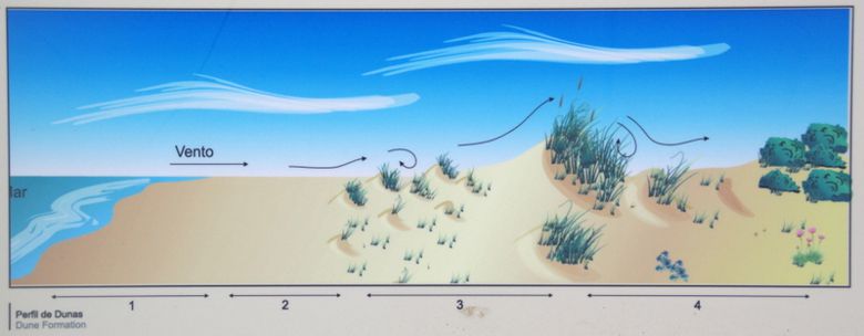
- Beach driftline – almost devoid of surface vegetation and colonized only by invertebrates attached to rocks or buried in the sand.
- Beach plains – mobile, almost bare, with a light covering of coarse grass, The sand itself, on dying out, is carried by the wind and accumulates on the upper parts of the beach.
- Embryonic or Primary dunes – small mounds of sand built up which provide the conditions necessary for the subsequent development of pioneering vegetable covering. Marram grass is particularly important but sea-holly, purple spurge and kale also play a significant role here.
- The dune continues to grow as the sand is deposited and the vegetation becomes denser, guaranteeing its continual maintenance. In this way, fixed dunes (Secondary or stabilized dunes) are formed, which, in addition to the flora mentioned, can support plants that are more demanding because they require lower levels of sand deposit.
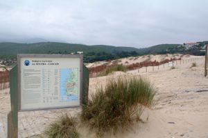
 The rehabilitation and preservation of the dune field is being carried out in three phases. 1- Limiting the aimless wandering of people through the dune field by placing pathways. This preserves the geology and the flora; 2- because dunes are an open and active geological system, Ammophila arenaria, subspecie arundinacea, is being planted in rows perpendicular to the prevailing wind and sand transport direction; and 3- the exotic species of plants are being removed.
Claiming a found:
At ground zero, face N (towards the mountain) and count the number of rows of Ammophila arenaria planted both parallel and perpendicular to the shore line. In addition calculate how high the plants are in this location and what is their predominant colour (blue, yellow, red, brown, green are your options). If you think you know all the answers, please log your found but send me, through my profile, the answers (*). If they are correct, you will not hear from me again but know that I truly appreciate you taking the time to visit this dune field and I hope that you have leran a little bit more about the geological processes that take place on the surface of the earth. If they’re wrong I will send you a explanatory note showing you where you went wrong. If you don’t send the answers, your log will be deleted without any explanation.
(*) Please note that when you e-mail me, please supply the reference (GC2K9GN) and name (1,519,322.31€ - DP/EC58) of the cache and please click on the “I want to send my e-mail address along with this message” so that when I reply to you the messages don’t go into e-mail heaven (or hell).


 Introdução
O título pode parecer estranho, mas reflecte a quantidade de dinheiro que o município de Cascais está a gastar na preservação do sistema dunar Guincho-Cresmina com a ajuda do programa Quadro de Referência Estratégico Nacional (QREN). O QREN assume como grande desígnio estratégico a qualificação dos portugueses e das portuguesas, valorizando o conhecimento, a ciência, a tecnologia e a inovação, bem como a promoção de níveis elevados e sustentados de desenvolvimento económico e sócio-cultural e de qualificação territorial, num quadro de valorização da igualdade de oportunidades e, bem assim, do aumento da eficiência e qualidade das instituições públicas.
Esta é uma das raras ocasiões em que o dinheiro está a ser investido em geologia (e um pouco de biologia também).
As dunas. Porque são importantes?
O sistema dunar do Guincho-Cresmina-Oitavos é bastante particular, pois a areia das dunas, provenientes das praias do Guincho e da Cresmina, retorna ao mar mais a sul (entre Oitavos e a Guia), após migrar sobre a plataforma Cretácica aplanada do Cabo Raso. Por este motivo, este sistema designa-se por corredor eólico do sistema dunar Cresmina-Oitavos.
Formação de dunas costeiras
dunas costeiras são acumulações de areia construído pela acção conjunta do mar e do vento. São estruturas frágeis, mas extremamente importantes, uma vez que protegem as áreas mais interiores de invasões do mar. Veja também: Wind Ripples - DP/EC 18 (GC1CZEE).
1 – Zona entre marés – Praticamente despida de vegetação superior e apenas colonizada por invertebrados fixos nas rochas ou enterrados na areia.
2 – Areias de praia - móveis, quase nuas, habitat do feno-da-areias e da eruca-marítima. A areia, após secagem, é transportada pelo vento, depositando-se na zona superior da praia.
3 – Dunas embrionárias ou dunas primárias – Formam-se pequenas elevações de areia com condições para o desenvolvimento de um coberto vegetal pioneiro, responsável pela acumulação das areias. O estorno é particularmente importante, mas também os cordeiros-da-praia, a couve-marítima, o cardo-marítimo, a maleiteira-das-areias.
4 - A duna continua a crescer à medida que mais areia se deposita e a vegetação dunar torna-se mais densa, garantindo a sua manutenção. Formam-se assim a dunas fixas (dunas secundárias ou estabilizadas) onde pode surgir a mesma flora, mas acompanhada de outra menos resistente à deposição de areias: a granza-da-praia, a perpétua-das-areias, o trevo-de-creta, a madorneira, a sabina-de-praia, o goivinho-da-praia, a couve-marítima.
 A reabilitação e conservação do campo dunar está a ser realizado em três fases. 1 – Tratando-se de uma zona muito instável devidos aos fortes ventos predominantes de NW e a grande pressão humana pretende-se ordenar o acesso pedonal através da delimitação de trilhos; 2 - porque as dunas são um sistema aberto e geologicamente activo, Ammophila arenaria, subespécie arundinacea, está sendo plantada em linhas perpendiculares à direcção predominante do vento e transporte de areia; e 3 – a remoção de espécies exóticas invasoras.
Para logarem esta EC:
Nas coordenadas indicadas, vira-te para N (para a Serra de Sintra) e conta o número de linhas de Ammophila arenaria plantadas paralelas e perpendiculares à linha de costa. Além disso calcula a altura das plantas que vês quando virado para N e qual é a sua cor predominante (azul, amarelo, vermelho, castanho, verde são as tuas opções). Se achas que sabes todas as respostas, por favor faz o teu log de “found”, mas ao mesmo tempo envia-me as respostas a estas perguntas(* - ver em cima).
Se estiverem correctas, não respondo mas fica sabendo que eu estimo a tua visita ao campo dunar e espero que esta cache sirva para desvendar mais um mistério dos processos geológicos da nossa bola azul. Se estiveram erradas, vais a exame novamente e levas com TPC’s extras. Porém se não enviares as respostas, simplesmente apago o log.

 The most exciting way to learn about the Earth and its processes is to get into the outdoors and experience it first-hand. Visiting an Earthcache is a great outdoor activity the whole family can enjoy. An Earthcache is a special place that people can visit to learn about a unique geoscience feature or aspect of our Earth. Earthcaches include a set of educational notes and the details about where to find the location (latitude and longitude). Visitors to Earthcaches can see how our planet has been shaped by geological processes, how we manage the resources and how scientists gather evidence to learn about the Earth. To find out more click HERE.