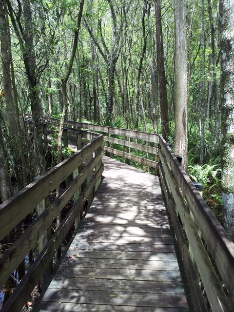
Finally a cache request has been approved for this unique piece of "Old Florida!" Around 1976, a group of Lee County students, known as "the Monday Group", became alarmed at the rate at which the environmental treasures of our area were being developed. They launched a campaign to save the Six Mile area. Lee County voters responded and the land was purchased. Through their efforts and those of others in Lee County, in 1991 Lee County Parks and Recreation opened the Preserve's boardwalk to the public. Almost twenty years later, the boardwalk looks like it has always been there and the 8-year-old cypress trees that were planted at the walk's beginning are now 25-30 feet tall! Come and enjoy this unique glimpse into what Florida used to look like, from the comfort of a wheelchair-accessible walkway.
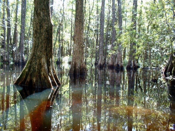
A "slough" (pronounced "slew") is a geographical feature commonly found in southern Florida. It is a natural depression that forms a drainage-way for run off from the heavy rainfall in the hurricane season from June to November. The surrounding area is made up of mainly well-aerated sandy soil. In the slough, which may be only inches lower, a sandy loam with greater moisture is found. The central area of the slough is deeper and under water most of the year. In this portion "Flag Ponds" are found that almost never dry up. These ponds are connected by a series of flow-ways, enabling fresh water to pass through the slough year round. This creates a "Linear Ecosystem." The Six Mile Slough drains a watershed of 33 square miles. The slough itself is 2,500 acres in area and 9 miles long by 1/3 mile wide. The fresh water flowing through the slough eventually empties into the Estero Bay Aquatic Preserve and eventually the Gulf of Mexico. Occasionally islands of slightly higher ground, known as "Hammocks" are found in the central area allowing plants that could not live in water to survive and a resting place for many animals.
To get credit for this Earth Cache, please post in your log the height of the water (above sea level) near the beginning of the walkway (On measuring gauge, N 26 34.317 W 081 49.546 {Just before the entrance gate} The height is in feet and tenths-of-a-foot. 14.8 feet, for example) so that an idea of the water level at different times of the year can be established. Future visitors can also get a better idea of when the area is dry or fully submerged. As the water level rises and falls, the slough becomes a perfect habitat for a changing variety of wildlife. Other species are year round residents.
Next email me with the answers to the following questions. The answers can be found on the information plaques found along the boardwalk.
(1) Throughout the wet season,June-November, a depth of ?-? feet of water makes the Slough comparable to a wide but shallow stream? (post#4,(at the Amphitheater)
(2) This slough was once considered a nuisance to progress. What valuable functions does it provide? (Slough Interpretive Trail Plaque in amphitheater #4)
(3) What are the 4 parts of the slough? (Plaque at post #6)
(4) How many insects can a bat "gobble up" in one night? (Plaque near post #8)
(5) During the dry season, how do the "Gators" change the slough? (Plaque at Otter Pond #13)
(6) Does the Pop Ash Pond always have water in it? (Plaque at Pop Ash Pond #14)
For extra credit, email me with the names of the six types of animals that have left their tracks on the boardwalk (tracks painted on walkway).
Before leaving the Preserve, please visit the new "Green" ecocenter located at the parking lot. They can provide you with a wealth of information on the ecology of the preserve and answer questions! Have fun and enjoy the walk (about 1.2 miles) Check the Photo Gallery for photos of the Slough.
CONGRATULATIONS to Blue Diamonds and joshandmarce for the co-FTF!!!