Lawrence Hargrave Drive is one of the most scenic roads in Australia but was notorious for rock falls, embankment slips, mud and rock slides due to high rainfall, marine erosion, weak rock and the weathering of rock features. These rock falls have caused many road closures throughout the road's history since it was opened in 1878. In 1967 the road was closed for two months due to rock falls and in the period from 1913 to 2002 12 incidents involving landslides interacting with vehicles or people were identified.
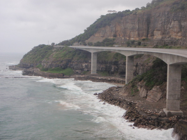
The Sea Cliff Bridge
In August 2003, a large embankment slip called for a complete road closure. The road remained closed for two and a half years to avoid further rock falls and slippage problems, and to allow for the construction of the Sea Cliff Bridge.
The Sea Cliff Bridge is built out from the cliff faces away from the danger of rock falls and embankment slippages eliminating the danger.
Lawrence Hargrave Drive was reopened in December 2005.
The Sea Cliff Bridge now provides an ideal viewing platform to examine the lower layers of the Illawarra Escarpment.
Geology
The Illawarra Escarpment stretches from Stanwell Park in the north (where this Earthcache is located) to Kiama, Gerringong and the Shoalhaven River to the south.
The escarpment cliffs and plateau are made up of massive beds of durable quartz sandstone (you might just be able to see the cliffs right up the top of the escarpment from some vantage points on or around the bridge). Beneath the cliffs, weaker claystone tends to erode more rapidly and undermine the sandstone - causing the cliffs to periodically collapse (and of course this is why the bridge was built).
The steep slopes that sweep down from the cliffs to the coastal plain are made of shales, claystones and coal seams. Large sandstone boulders at the base of the slopes are evidence of cliff collapse. The slopes are also prone to landslip. Material that has slid or fallen from the cliffs and upper slopes form thick layers on the lower slopes and foothills.
In many places, erosion-resistant layers of claystone protrude from the slopes and form flat benches. The shales and claystones on the escarpment provide the high nutrient levels required to support the lush rainforsts that grow on the escarpment.
Further information regarding the site can be found here.
The Earthcache
In order to log this Earthcache, you'll need to answer the following questions and email your answers for permission to log. Logs without permission may be deleted. It is also preferable that you upload a picture of you/ your group and your GPSr on the bridge (but not with the cliffs in the background) with your log.
At GZ you'll find a sign (the sign is a little faded but there is also a replica of this sign given as a waypoint as an alternative). There is a panel entitled 'Why build the bridge?'. Read the panel and send answers to the following questions:
1. The lower area of the rock formation is a section of the what?
2. What is this lower section made up of?
Wander along the bridge northwards to around S 34 15.302 E 150 58.388.
At this point look westwards (away from the sea) towards the lower section of cliffs where the old road used to be. Above the fence there is a band of the cliff that has had some alteration.
3. Describe what man made alteration has been made to the cliffs and why you think that is has been done.
Wander further along the bridge to around S 34 15.193 E 150 58.460. If you look westwards and upwards from here you can see a spectacular amphitheatre of rock. There are two distinctive large sections of rock separated by some greenery.
4. Describe each of the two sections in terms of their colour and composition. Do they look different?
Note two additional waypoints have been added to the listing- one for a sign to the north of the Earthcache which is the same at that at the given co-ordinates and can also provide you with the answers to Questions 1 and 2 and two for parking at the northern end of the bridge should you wish to tackle the Earthcache from that direction.
 References:
http://en.wikipedia.org/wiki/Illawarra_escarpment
Grand Pacific Drive
http://www.coffey.com/Uploads/Documents/Slope-hazard_20070123010834.pdf