The geology seen in the Grand Canyon can be broken down into three sections. The oldest section of Vishnu Basement Rocks were formed from 1840-1680 million years ago, and is a combination of sedimentary and igneous layers than were then metamorphosed by heat and pressure and intrusions of igneous rock. Above this bottom section are several missing layers, the absence of which was termed “the Great Unconformity” by John Wesley Powell.
The next section is called the Grand Canyon Supergroup, which formed from 1200-740 million years ago. These layers of sedimentary rock were laid down in basins created as land masses shifted. The continued movement of the land masses causes the supergroup to tilt 15 degrees in a north south orientation.
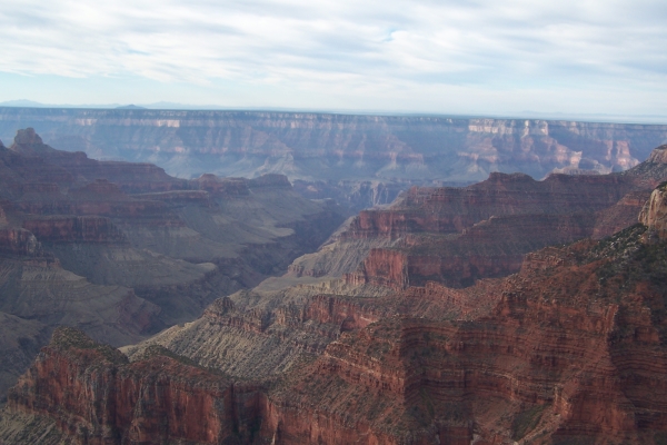
The upper two thirds are the Paleozoic Sedimentary Rocks. The oldest Tapeats Sandstone layer formed 525 million years ago, while the more recent Kaibab Formation formed 270 million years ago. These layers, which are horizontal, are filled with plant and animal fossils reflecting sea floor and river delta origins. Anciently, the Grand Canyon was an inland sea, with layer after layer deposited over millions of years. The uplift of the Colorado Plateau caused these layers to rise thousands of feet above sea level. Drainage from the Kaibab portion of the Colorado Plateau, rich in heavy sediment, and powered by a steep elevation gradient, enabled the Colorado River and its tributaries to cut the canyon out of these many layers. Ice Ages contributed by causing the river to flow up to 10 times the volume of today’s Colorado River. This erosion is geologically recent, occurring in the last 5-6 million years.
The uplift of the Colorado Plateau caused these layers to rise thousands of feet above sea level. Drainage from the Kaibab portion of the Colorado Plateau, rich in heavy sediment, and powered by a steep elevation gradient, enabled the Colorado River and its tributaries to cut the canyon out of these many layers. Ice Ages contributed by causing the river to flow up to 10 times the volume of today’s Colorado River. This erosion is geologically recent, occurring in the last 5-6 million years.
This earthcache will take significant time and study to complete. Essentially there are two major requirements: you must hike from one end of the canyon to the other, and you must answer a number of questions about the geology of the Grand Canyon. It is my belief that the Grand Canyon requires hiking to the bottom from Rim to Rim to truly appreciate the complexity of this geology.
The information you will need to answer the questions can be obtained both by careful observation of the layers of rock as you pass down into and up out of the Canyon, and by study of the details of these layers. I strongly recommend obtaining at least a basic understanding of the geology before you go into the canyon. Additional resources are listed below:
The North Rim Trail Guide (http://www.nps.gov/grca/parknews/upload/2010NRguide.pdf)
The Visitor Brochure you receive when entering the park.
http://en.wikipedia.org/wiki/Grand_Canyon
http://en.wikipedia.org/wiki/Geology_of_the_Grand_Canyon_area
http://www.nature.nps.gov/geology/education/foos/grand.pdf
While not a requirement, these suggestions will make your quest easier:
1. Read about the canyon before you begin your hike.
2. Take photos at the various locations for your reference
3. Stop at a visitor center to any unanswered questions you have. Information learned during a Ranger talk at Phantom Ranch inspired me to develop this cache.
Hiking Rim to Rim is no small undertaking. It requires fitness and planning. I do not recommend trying to do it in one day. In addition to the physical difficulty of such a plan, you will not have time to fulfill the requirements if you are doing 28 miles (plus 6000 feet down and 5000 feet up) in one day. Staying overnight will require reservations at either Phantom Ranch or one (or more) of the campgrounds, which are hard to obtain and require months of preplanning. Please go to the following website for more information:
http://www.nps.gov/grca/planyourvisit/overnight-hiking.htm
Once you make the appropriate arrangements you are ready to fulfill the requirements.
Hiking Rim to Rim is no small undertaking. It requires fitness and planning. I do not recommend trying to do it in one day, as you will not have time nor sufficient daylight to get the information that you need.
To successfully log this Earthcache, once you have visited the cache locations, send me an email with Rim to Rim GC2JWK8 in the first line, the date(s) of your journey, and answers to the following questions. Due to the removal of interpretative signs on the North Kaibab trail (the virtual location waypoints still listed on this Earthcache page), questions A-H have alternative questions. You are free to answer either the primary or alternative, but each must be answered. Questions I-M must be answered as written.
A. The Supai formation consists of many layers. What is the origin of the upper and middle layers?
A Alternate: Describe the Supai layers which include the Supai tunnel: It is a single cliff, a gradual slope or a series of step like cliffs?
B. What is the origin of the lower layers of the Supai formation?
B Alternate: How long is the Supai Tunnel, and why do you think it was necessary?
C. What kind of climate existed during the deposition of the Supai layers?
C Alternate: When you emerge from the Supai Tunnel, are you on the Left (east) or Right (west) side of the canyon?
D. How did the Redwall limestone form, and what accounts for a large amount of this limestone?
D Alternate: Is the Redwall bridge at the top or the bottom of the Redwall layer. Why do you think so?
E. The Muav limestone is remarkable for containing what inorganic substance?
E Alternate: The Redwall layers is actually another color of rock that is stained with iron from layers above. A prominent stopping point in the Redwall layers is Eye of the Needle, which has several colors of rock. Name at least three colors that you can see besides red?
F. Why are the layers from the Ordovician and Silurian Periods layers missing between the Redwall and Muav Limestone layers?
F Alternate: Roaring Springs emerges just under a layer of rock. What color is it and what is the layer?
G. What layer is present between these two levels (Redwall and Muav Limestone) but is mostly eroded away?
G Alternate: The water from Roaring Springs flows downhill to cross the Colorado River via pipeline to Indian Gardens (at this point there are pumps to convey it uphill to the South Rim). Explain why no pump system is needed for this journey. It may help to compare the rock layers of Roaring Springs (Mauv Sandstone) and Indian Gardens (Tapeats Sandstone).
H. What color is the layer in question G?
H Alternate: Ribbon Falls is located on which side of Bright Angel Creek? How do you think it got its name?
I. Why do you think the canyons on the North Rim are so much deeper and further from the river than those on the South Rim? How is this related to the fact that the North Rim is higher than the South Rim?
J. Compare the elevation of the Tapeats Sandstone on the North Rim (Caretakers House, N36 11.150 W112 01.926) with the South Rim (Indian Gardens, N36 04.699 W112 07.655). Why is there an elevation difference?
K. Between Ribbon Falls (N36 09.516 W112 03.138) and Phantom Ranch (N36 06.328 W112 05.682) look for evidence of the Grand Canyon Supergroup. Describe how you would distinguish the supergroup from the Vishnu Basement Rocks.
L. At Plateau Point (N36 05.592 W112 06.996) [or alternately Tipoff on South Kaibab (N36 05.510 W112 05.410)] compare the rock layers below with those above the level on which you stand. What differences do you see in these rock layers (what type of rock do you see)?
M. At 3 Mile Resthouse (N36 03.944 W112 08.165) [or alternately Skeleton Point (N36 04.925 W112 05.418)], look north across the river to the North Rim. Which of the three major layers (Vishnu Basement Rocks, Grand Canyon Supergroup, Paleozoic Sedimentary Rocks) can you identify?
New requirement 2024: post at least two pictures of your trek. One should be from the North Kaibab trail and one from the Bright Angel OR South Kaibab. Each should be at a readily identifiable point (see the waypoints above) and include yourself OR a personal item. The photos should be clear enough to prove that you physically visited the location.
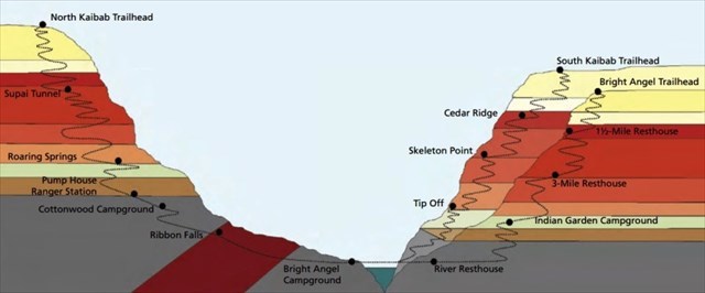
To successfully log this Earthcache, you will need to hike rim to rim to complete the logging requirements. Rim to rim means that you traverse the entirety of the North Kaibab and Bright Angel Trails, including the three mile hike to Plateau Point (total length is 28 miles), or alternately North Kaibab and South Kaibab trails, total 21 miles (but steeper and no water). This trek would include all of the following points: North Kaibab Trailhead, Supai Tunnel, Eye of the Needle, Roaring Springs, Ribbon Falls, and Phantom Ranch. You must then visit either River Resthouse, Indian Gardens, Plateau Point, 3 Mile Resthouse, and Bright Angel Trailhead; or Tipoff, Skeleton Point, Cedar Ridge, and South Kaibab Trailhead. Please note that this Earthcache is nearly impossible to do in one day, and cannot be logged if significant portions of the hike are completed in the dark. Hikes done before the cache was "hidden" do not count as finds. Photos of the various locations are now required as there has been a change in Earthcache guidelines, to distinguish a true Rim to Rim hiker from an Internet find. Do not post pictures that contain answers to the questions.
All photos taken by Opjim or family.