The Fraser River is the longest river within British Columbia, rising at Fraser Pass near Mount Robson in the Rocky Mountains and flowing for 1,375 km (870 mi), into the Strait of Georgia at the city of Vancouver. This vast river carries with it over 20 million tons of sediment each year to the Pacific Ocean as it passes by Fort Langley.
At the start of the 1900's, there were two islands in the Fraser River, north of Fort Langley, Brae Island and McMillan Island that were separated by an un-named channel. This channel is possibly the reason why the Halq'eméylem word for the island is Sqwàlets, meaning "the river went through."
Aerial photography from 1938 illustrates that a large portion of island is likely the result of depositions caused by the construction of the Jacob Haldi Bridge in the 1920’s . The photo shows that a significant portion of the island was located under the waters of the Bedford Channel prior to this period. Depositions caused by construction of the Haldi Bridge; periodic inundations during freshets*; and applications of Bedford Channel dredgate during the latter part of the 20th century all contributed to the eventual formation of the rest of the island.
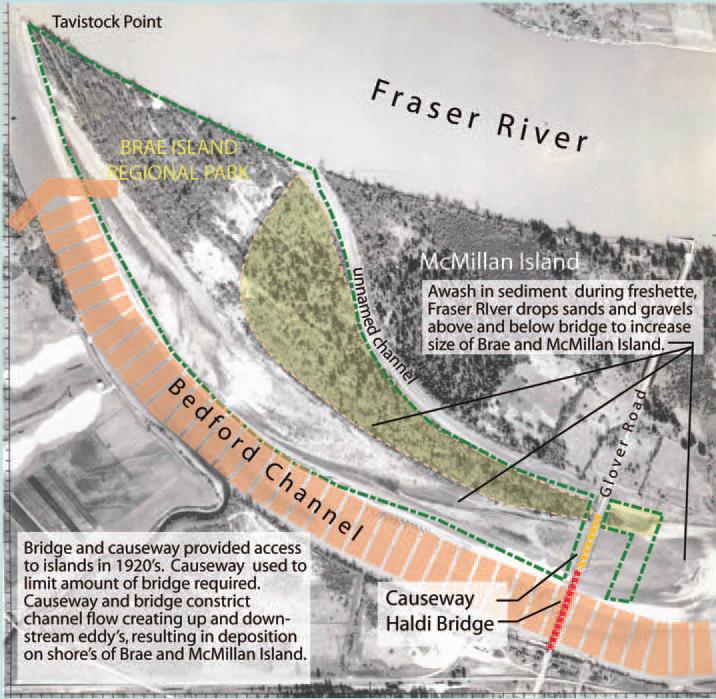
In the 1920's a causeway was built on McMillan island to facilitate the construction of the Jacob Haldi Bridge, which considerably narrowed the Bedford channel. This narrowing of the channel caused the river flow to be interrupted creating back eddys which allows the river to drop some of the sediment that it carries. As this sediment accumulates, it further restricts the channels flow. During a freshet*, sediment laden river water is allowed to flow over top of this deposit adding more silt to the area, building up the banks to a level that is much higher than the nominal height. Eventually the upstream portion of the un-named channel was completely filled by this sediment, thus combining the two islands. The downstream section of this channel still remains as a tidal slough. Being relatively close to the Pacific Ocean, this area of the river is also affected by the tides. When the tide is high it causes a slight slowing of the river flow rate. This slower speed allows some of the carried sediment to fall from the water to further increase the deposits along the edges of the island.
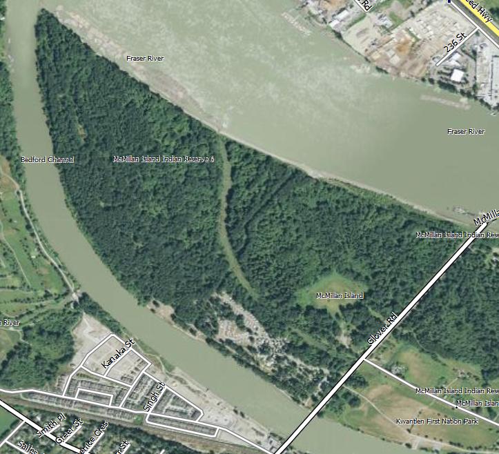
Below is an aerial image of how the island appears today.
* A "freshet" is defined as: A flood resulting from heavy rain or a spring thaw. Whereas heavy rain often causes a flash flood, a spring thaw event is generally a more incremental process, depending upon local climate and topography. The term freshet is most commonly used to describe a spring thaw resulting from snow and ice melt in rivers located in the northern latitudes of North America, particularly Canada, where rivers are frozen each winter and thaw during the spring. A spring freshet can sometimes last several weeks on large river systems, resulting in significant inundation of flood plains as the snow pack melts in the river's watershed.
If you are a local and have wondered why Brae Island Regional Park, is located on McMillan Island, I hope this earthcache has helped explain that to you.
In order to log this earthcache you must email me the answers to the following two questions:
1:) At the posted cache co-ordinates, examine the river bank material and describe its consistency, rocky/sandy/muddy etc
2:) Looking across Bedford channel from this same spot, identify the surface of the opposite bank (you should be able to tell from here but if you cannot you will get a closer look as you return from the island crossing the Haldi bridge). Why do you think it differs?
Optional tasks:) Post a picture from anywhere on the island (no spoilers please), and give a name to the un-named channel (imaginary bonus points for being a historically relevant name)