|
O Nascimento de uma Estrela [Serra da Estrela]
The Birth of a Star
[PT] Toda a grande superfície de aplanamento que se estende na base da Serra, cortada pelo Rio Mondego, corresponde à grande superfície fundamental da meseta que se estendia pela península Ibérica. No início do período Terciário, forças de compressão, relacionadas com os movimentos alpinos, vão provocar o rejogo das antigas falhas hercínicas, que passam de falhas de desligamento a falhas inversas. No Miocénico superior, há 10 milhões de anos, iniciam-se os primeiros movimentos de subida dos blocos que formam a Serra da Estrela, segundo o modelo Pop-Up (Fig.1), continuando por impulsos sucessivos até ao último, que terá ocorrido há cerca de 2 milhões de anos e que marcou a sua estrutura actual. Este fenómeno deu origem à elevação da montanha, por movimento em sistemas de falhas paralelas, o que originou blocos diferencialmente desnivelados, provocando o efeito de escadaria (Fig. 2), culminando com o planalto da Torre, com que a Serra da Estrela se apresenta. A actividade tectónica, contudo, não se extinguiu, existindo, ainda hoje, actividade neotectónica, com movimentos ao longo das grandes falhas, como provam a ocorrência de nascentes termais e de pequenos sismos, frequentes na região.
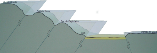
E assim nasceu a Estrela, a “Serra da Estrela”. Neste local estes patamares desnivelados são perfeitamente identificáveis, não tendo ainda sido degradados pela erosão.
A EarthCache:
Para que o log seja validado, deve enviar-me por email as respostas às seguintes questões:
A – De frente para o Vale, as rochas à sua direita foram esculpidas pela erosão. Maioritáriamente as "riscas" estão na horizontal ou na vertical?
Infelizmente dado o desaparecimento do placard a pergunta original (Complete a frase: “Toda a grande superfície de aplanamento que se estende na base da Serra, cortada pelo rio Mondego, corresponde à grande superfície fundamental da meseta, que foi arrasada e aplanada durante o”…) ficará desativada!
B – Na coordenada indicada, olhando para Sul em direcção ao topo da Serra, quantos patamares consegues identificar?
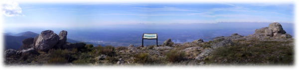
As vistas são fenomenais, tire fotos às curiosas formações rochosas e divirta-se.
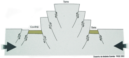
(Fig. 1)
(Fig. 2)
[EN] The entire and flat surface at the base of this mountain, cut off by the “Mondego” river, corresponds to the large central area of the plateau stretching across the Iberian Peninsula. At the beginning of the Tertiary period, compressive forces related to the Alpine movements, will cause the readjustment of the old hercynian failures, transforming them into reverse faults. In the upper Miocene, 10 million years ago, begins the first movements of rising blocks that form the “Serra da Estrela”, by the Pop-Up model (Fig. 1), continuing for successive pulses until the last, which took place about 2 million years and who has marked its current structure. This has led to the elevation of the mountain, by motion in systems of parallel faults, which resulted in uneven differentially blocks, causing the effect of steps (Fig. 2), culminating with the plateau of the “Torre”, as the “Serra da Estrela” is presented to us today. The tectonic activity, however, have not been extinguished and there is, even today, neotectonics activity with movements along major faults, as evidenced by the occurrence of thermal springs and small earthquakes, common in the region.
And so, was born a Star, "Serra da Estrela" (Star Mountain). In this place, these uneven levels, are clearly identifiable and has not yet been degraded by erosion.
The EarthCache:
In order to validate the log, you must send me by email the answers to the following questions:
A – Facing the valley, the rocks on your right were carved by erosion. Mainly, the "stripes" are horizontal or vertical?
Unfortunately the placard is gone. Facing that the original question (Complete the sentence: “Toda a grande superfície de aplanamento que se estende na base da Serra, cortada pelo rio Mondego, corresponde à grande superfície fundamental da meseta, que foi arrasada e aplanada durante o”…) is disabled!
B - In the given coordinate, look south towards the top of the mountain, how many levels can you identify?
The views at the site are phenomenal, take pictures to the curious rock formations and have fun.
Bibliografia: Site “Um olhar sobre a Serra da Estrela” and the onsite placard.
|