Zwei Vulkanausbrüche schufen einen Berg, wo vorher keiner war. Das erste mal vor etwa 32 Millionen Jahren. Aufsteigende Magma bahnt sich seinen Weg durch Schiefer-, Kalk und Sandsteinschichten nach oben und reißt mit ungeheurer Kraft Gesteinsblöcke mit sich. Mit großer Wucht werden die Bruchstücke aus dem Schlot hinausgeschleudert und vermischen sich mit dem Ascheauswurf. Bis heute sind an den Abbruchkanten im Steinbruch die hellen Gesteinsblöcke inmitten der dunkleren Ascheablagerungen sehr gut zu erkennen. In diese noch lockeren Ablagerungen dringt weiteres Magma aus dem Erdinneren nach oben und bildet eine birnenförmige Basaltkuppe.
Der zweite Ausbruch vor etwa 24 Millionen Jahren fällt deutlich ruhiger aus. Wieder steigt Magma auf und schiebt sich unter den erstarrten Basalt des ersten Ausbruchs.
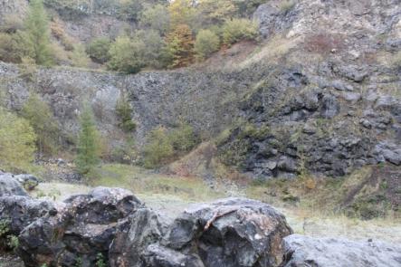
Früher war der Arensberg deutlich höher. Während an den alten Ascheablagerungen des ersten Ausbruchs die Jahrmillionen zehrten, waren es dann im 19 Jahrhundert die Menschen die dem Berg den Gipfel nahmen. So musste auch die Ruine einer mittelalterlichen Kirche dem Basaltsteinbruch weichen. An sie erinnert heute die kleine Kapelle am Wegesrand. Nach und nach drang man immer tiefer in den Berg vor und folgte dem Schlot in die Tiefe. Heute bietet sich im alten Steinbruch ein beindruckender Blick in das Innere eines erloschenen Vulkans.
Parken kann man an den Koordinaten bei N 50° 17.096 E 006° 43.733 Ab hier führt dich eine Weg direkt in den Schlund des Vulkans.
Gehe zu den angegebenen Koordinaten und studiere die Informationstafel in der Nähe.
Um den Cache zu loggen beantworte bitte folgende Fragen.
1. Was lässt sich an Hand der Buntsandstein und Muschelkalk- Gesteinseinschlüssen in Basaltlava und Tuffen des Arensbergs belegen?
2. Was wird durch Abb. 1 der Infotafel beschrieben?
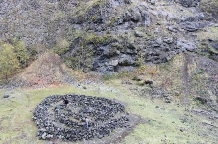
3. (Optional) Mache ein Bild im Inneren des Arensbergs in der Nähe der Listingkoordinaten oder einer anderen interessanten Stelle und poste es im Log!
Aus Gründen des Schutzes der eigenen Persönlichkeit musst du weder dich noch dein GPS auf dem Foto darstellen, darfst es aber gerne optional tun.
Schicke deine Antworten bitte an
earthcache-mrkrabs@online.de
oder über mein GC-Profil und du darfst sofort loggen. Bei Unstimmigkeiten melde ich mich bei dir.
The Arensberg volcano
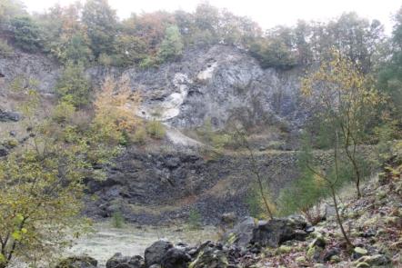
Two volcanic eruptions created a mountain here were none had existed before. The first eruption took place approximately 32 million years ago, when rising magma forced its way upwards through layers of slate, lime and sandstone, sweeping up blocks of rock with tremendous power as it flowed.
The blocks were hurled out of the vent with great force and became intermixed with ejected ash. Today, the paler blocks of rock can still be clearly seen amidst the darker deposits of ash at the edges of rock faces in the quarry. Further magma from the earth`s interior forced its way upwards through these as yet unconsolidated deposits, forming a pear-shaped basalt mound.
The second eruption approximately 24 million years ago was a much calmer affair. Magma once rose upwards and simply pushed its way under the solidified basalt of the first eruption.
The Arensberg was originally much higher. While the old deposits of ash were subject to erosion during the millions of years following the first eruption, it was humans who removed the mountains top in the 19th century. The ruins of a mediaeval church too had to make way for the basalt quarry. A small chapel at the side of the path serves as reminder of it today.
The quarry gradually penetrated further and further into the mountain, even continuing down into the vent. Today, the old quarry offers an impressive view of the interior of an extinct volcano.
Go the the coordinates and study the information board!
You can park nearby the coordinates at N 50° 17.096 E 006° 43.733 From here a path leads you directly to the funnel of that volcano.
To log the Cache answer the questions.
1. What can be documented by the sandstone and the shell limestone inclusions in the basalt lava and the tuff of the "Arensberg"?
2. What is described by Abb.1 at the information board?
3. (Optional) Take a picture nearby the coordinates or another interesting place and post it in your log!
For reasons of protection of your own personality you must show neither you nor your GPS in the photo, but you can do this optional.
Send your answer to
earthcache-mrkrabs@online.de
or write by GC.com Formular and you can immediately log the Cache. At inconsistencies I will contact you.