 Listing in English
 Listing in Deutsch
 Vrelec naravne mineralne vode Nuskova
trak ukrep prinašajo
Severovzhodna Slovenija je bogata z termalnimi in mineralnimi vodami. V okviru raziskovanja nafte in plina je bilo v zadnjih petdesetih letih odkritih vec izvirov mineralne in termalne vode. Najbolj znan je verjetno v Radencih, kjer crpajo mineralno vodo za podjetje Radenska. Poleg omenjenega vrelca je tam še vec manjših izvirov, ki pa še niso izkorišceni in bi lahko bili zanimivi tudi z ekonomskega vidika. Izvir Nuskova je dostopen javnosti in spada med vrelce, ki se še ne uporabljajo v komercialne namene. Z geološko kemijskega vidika je izvir v Nuskovi zanimiv zaradi visoke koncentracije bikarbonata in vzroka obogatitve z njim. Zanimiva je tudi visoka vsebnost železa, ki pokriva obmocje okoli izvira z rdeco oblogo.
Pitna voda
 Pitno vodo je mogoce dobiti na razlicne nacine – iz virov kot so podtalnica, deževnica, voda iz izvirov, iz rek ali jezer.. Obicajno so površinske vode bolj onesnažene, kot podzemne. Zaradi tega je podzemna voda najbolj priljubljen vir za proizvodnjo pitne vode. Pitna voda mora imeti visok nivo cistoce, koncentracija mineralov pa se mora gibati v dolocenih mejah, ki so standardi za pitno vodo. Snovi, ki so v vodi, so odvisne v glavnem od vira in zgodovine vode. Ko kupujemo vodo v plastenkah ali jo natocimo iz pipe, voda ni le prepotovala dolgo pot od izvira do našega doma, ampak je dalec potovala tudi skozi razlicne plasti tal. Deževnica prodre globoko v zemljo skozi razlicne sloje kamnin. Zaradi tega procesa je voda ocišcena, filtrirana in obogatena z minerali, mikroelementi in ogljikovimi kislinami. Glede na lastnosti vode in metodo obdelave, je lahko koncni izdelek bodisi izvirska, mineralna, termalna ali kurativna voda, namenjena uporabi v medicini (zdravljenje z vodo). Izvirska voda je podzemna voda, ki pritece na površino zemlje iz globin.
Prihaja iz naravnih podzemnih rezervoarjev, ki so zašciteni pred onesnaženjem. V skladu s priporocilom Sveta Evropske skupnosti mora "naravne mineralne vode" vsebovati najmanj 1000 mg / l skupne raztopljene trdne snovi (TDS = total dissolved solids) v raztopini ali najmanj 250 mg / l prostega ogljikovega dioksida. Tipicni TDS so kloridne, sulfatne in hidrogenkarbonatne spojine z natrijem, kalcijem, magnezijem, železom in aluminijem. Termalne vode so vode, ki dosežejo površino zemlje pri temperaturi nad 20 ° Celzija. Imena in merila za razlicne vrste vode se lahko razlikujejo od države do države. Zaradi raznolikosti geoloških razmer, imamo tudi zelo razlicne mineralne in termalne vode.
Nekaj dejstev o geologiji severovzhodne Slovenije
 Severovzhodna Slovenija se nahaja v prehodnem obmocju med Panonsko nižino na vzhodu in Južnimi Alpami na zahodu. Najpomembnejša tektonska struktura je porecje Mure, ki je napolnjeno s sedimenti iz terciarja in kvartarja. Ceprav se je oblikovanje porecja Mure zacelo že v terciarju, se je glavni proces posedanja odvijal v poznem pliocenu in kvartarju. V procesu posedanja so nastale tudi globoko segajoce gube, med katerimi sta najpomembnejši Radgonska na severu in Ptujsko – Ljutomerska na jugu. Vzdolž teh gub sta nastali sinklinali (=vboceni del nagubanih zemeljskih skladov), ki se imenujeta Radgonska in Ljutomerska depresija, loci pa ju Mursko soboški plato. Tla Radgonske depresije so karbonati, naloženi na metamorfne kamnine, ki pa so tu v globini 2 km. Ti karbonati tvorijo termalni aquifer (termalno vodni podzemni bazen) z mineralno vodo natrij - bikarbonatnega tipa.
 V predelu Mursko - soboškega platoja, so metamorfne kamnine mnogo višje in segajo do globine 500m. V smeri Ljutomerske depresije se nato spet spustijo in jih v srednjem delu najdemo na globini 4 km. V tem predelu je na metamorfne kamnine naložen terciarni dolomit in tako se tvori aquifer, za katerega je znacilna voda bogata s soljo in CO2. Miocen se v Radgonski depresiji kaže kot morska plast gline, laporja, blata in peska. Kasneje se je okolje spremenilo v bolj slankasto (Pliocen) in v plast kontinentalno-fluvialnih in limnicnih sedimentov. (pozni pliocen in kvartar). Vzdolž globoko ležecih razpok predterciarnih kamnin prehaja velika kolicina ogljikovega dioksida in izstopa v obrobju Radgonske depresije. V procesu prehajanja se plin meša z vodo, se v njej raztaplja ter tako povecuje kemicno agresivnost vode, ki zato lažje raztaplja kamnine. Nuskova, Radenci in Benedikt so najpomembnejši vrelci v Radgonski depresiji.
Pogoji za vpis tega earthcacheja
- Odgovori na ta tri vprašanja:
| a) |
Kako se imenuje snov (slovensko ime), ki jo v vodi iz izvira Nuskova najdemo v koncentraciji 470mg/l? |
| b) |
Koliko mg/l hidrogen karbonata (Hidrogenkarbonat) je raztopljenega v vodi iz izvira Nuskova? |
Odgovora na ti dve vprašanji najdeš na informativni tabli ob izviru. Uporabi besede in števila tako, kot so zapisana na tabli.
|
| c) |
Kako dolgo (cm) je ena stran vodnjak kamna?
Merjenje enakostranični kamen na eni strani in se kot spremenljivo (c) pismo v skladu z naslednjo shemo:
Je dolžino med 41 in 43 cm, nato pa je (c) "A". Med 45-47=B, 49-51=C, 53-55=D, 57-59=E, 61-63=F, 65-67=G, 69-71=H, 73-75=I, 77-79=J, 81-83=K, 85-87=L, 89-91=M, 93-95=N in 97-99=O. Vzemi to pismo za "c". |
Na naslov elektronske pošte (a)(b)(c)@gmx.de pošlji prazno elektronsko pošto s tvojim GC imenom v naslovu. Pri tem naj bo namesto (a) odgovor na vprašanje a) in namesto (b), odgovor na vprašanje b) in namesto (c), odgovor na vprašanje c) - na primer: magnezij37A@gmx.de. Ce je naslov elektronske pošte pravilen, boš takoj dobil e-mail z dovoljenjem za vpis.
Po prejemu dovoljenja za vpis, lahko vpis online tudi opraviš. |
- V veliko veselje mi bo, ce boš vpisu dodal tudi fotografijo sebe in/ali tvojega GPS sprejemnika pred izvirom. Ta pogoj ni obvezen.
Posebej se želim zahvaliti cezanne in 5r za njuno pomoc.
Uživaj v naravni mineralni vodi!
Goyathlay
Natural mineral water spring Nuskova
measuring tape required
North-eastern Slovenia is rich of thermal and mineral water springs. In the course of the exploration for oil and gas deposits, several mineral and thermal water springs have been detected during the last fifty years. The best known spring is probably the one in Radenci which is exploited by the Radenska mineral water company. Apart from that spring there exist several smaller springs that could well be interesting from the economic point of view, but are not yet exploited. The spring in Nuskova is accessible to the public and belongs to the springs that are not yet used commercially. The geological/chemical interest of the spring in Nuskova is the high contain of bicarbonate and the reason of the enrichment. Also interesting is the high contain of iron, which covers the area around the spring with a red coat.
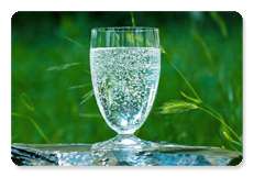
Drinking water
Water for drinking (potable water) can be obtained in various ways from sources such as groundwater, rainwater, water from springs and surface water from rivers, lakes and barrages. Typically surface waters are higher polluted than groundwater. For this reason, groundwater is a preferred source for the production of drinking water. Drinking water should have a high level of purity and the mineral concentration should be within certain limits set by quality standards for drinking water. The substances found in water mainly depend on the source and on the history of the water. When we buy water in bottles or take it from the tap in our homes, the water has not only underwent a long journey from the source until our homes, but also has experienced a long travel through various ground layers. Rainwater penetrates deeply into the ground and permeates through diverse rock layers and makes it way down to the source. In the course of this process it gets purified, filtered and enriched by minerals, micronutrients and carbonic acid. Depending on the properties of the water and on the processing methods the water is undergoing, the resulting product is referred to as spring water, mineral water, thermal water or curative-medical (healing) water, respectively.
Spring water is groundwater that flows on to the surface of the earth from below the surface. It origins from natural under-ground reservoirs that are protected against pollution.
According to a recommendation of the Council of the European Community "natural mineral waters" should a minimum of 1000 mg/l of total dissolved solids (TDS) in solution or a minimum of 250 mg/l of free carbon dioxide. Typical TDS are chloride-, sulphate- and bicarbonate compositions of natrium, calcium, magnesium, iron and aluminium.
Thermal waters are waters that reach the surface of the earth at a temperature of more than 20° Celsius.
The names and criteria for the different categories of water can vary from country to country.
The variety of the geological conditions result in a variety of mineral- and thermal waters.
Some facts about the geology of North-eastern Slovenia
North-eastern Slovenia is located in the transition zone between the Pannonian Plain (Basin) in the East and the Southern Alps in the West. The most important tectonic structure is the Mura basin which is filled with sediments from the Tertiary and the Quaternary. Although the formation of the Mura basin has already started during the Tertiary, the main process of subsidence took place in the late Pliocene and in the Quaternary. The subsidence processes formed deap-seated faults, the most important of which are the Radgona fault in the North and the Ptuj-Ljutomer fault in the South. Along this discontinuities two synclines have been formed which are separated from each other by the Murska-Sobota High (horst of Murska-Sobota) and which are named after the faults: Radgona depression and Ljutomer depression.
In the Radgona depression the basement consists of carbonates from the Mesozoic which superimpose metamorphic rocks in a depth of 2 km. The carbonates form a thermal aquifer with mineralized waters of the natrium-dominated bicarbonate type.
At the Murska Sobota High the Pretertiary, metamorph basement reaches up to until 500 m below the ground. In the direction of the Ljutomer-depression it deepens and attains a depth of about 4km in its central part. There relicts from Triassic dolomite superimpose metamorphic rocks and form an aquifer which is characterized by a richness of carbondioxide and the occurrence of a brine.
The Miocene of the Radgona depression manifests itself as marine fascies with clastic sediments of clays, marls, silts and sands. Later the environment changed to a brackish one (Pliocene) and to a continental-fluvial and limnic sedimentation fascies (late Pliocene and Quaternary), respectively.
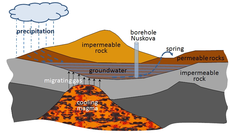
Along the deep-seated faults of the Pretertiary basement high amounts of carbondioxide migrate and crop out in the boundary zone of the Radgona depression. In the course of this migration process the gas mixes with water, dissolves in the water and reinforces the interaction between water and rocks (solubility properties) and the chemical aggressivity of the water.
The springs in Nuskova, Radenci and Benedikt are the most important mineral water springs in the Radgona depression.
Conditions for logging this Cache:
- In order to log this cache you'll have to answer the following questions:
| a) |
What is the name (slovenian) of the dissolved substance with a concentration of 470mg/l in the spring of Nuskova? |
| b) |
How many mg/l Hydrogencarbonate (Hidrogenkarbonat) are dissolved in the spring of Nuskova? |
| For answering the questions above look at the information board next to the spring. Use the words and numbers only as shown on the board. |
| c) |
How long (cm) is one side of the fountain stone?
Measure the equilateral stone on one side and take as variable (c) a letter according to the following scheme:
Is the length between 41 and 43cm, then is (c)="A". Between 45-47=B, 49-51=C, 53-55=D, 57-59=E, 61-63=F, 65-67=G, 69-71=H, 73-75=I, 77-79=J, 81-83=K, 85-87=L, 89-91=M, 93-95=N and 97-99=O. Take this letter for "c". |
When you have obtained all answers (words and numbers respectively), send me an (blank) e-mail with your GC-alias in the subject field to the following address: (a)(b)(c)@gmx.de. To obtain the first part (a)(b)(c) of the address put together the answers to the questions (a)-(c) above. For example, suppose that the answer to the first question is "Magnezij", the answer to the second "37" and the answer to the third "A", then the e-mail address is Magnezij37A@gmx.de. If you use the correct address, you will immediately get an automatic response with the permission to log.
Please wait for the log permission. |
- It gives me great pleasure if you add a photo of you and/or your GPS in front of the spring to your online log. That is an optional log requirement.
 I hope that you will like this cache and I am looking forward to your log.
If you wish, you can also rate this cache with the help of GCVote.
Especially I want to say thank you to cezanne and 5r for your support.
Enjoy the natural mineral water!
Goyathlay