The Angelina River
flows through high quality bottomland hardwood habitat
through this portion of the Pineywoods. If you visit this
area in the springtime, you will see that water fills the river
channel and spreads out across the forest.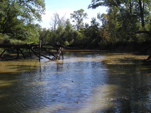 The plants here are adapted for this type
of annual cycle. The trees closest to the river channel and
in the lowest spots can tolerate the most frequent and extensive
flooding. Trees that tolerate such flooding less are found
higher on the slopes. The pines are generally the least
tolerant of flooding and they are found in the uplands. Here
at the Stephen F. Austin Experimental Forest, most of the other
caches are found in the upland areas amongst the pines.
The plants here are adapted for this type
of annual cycle. The trees closest to the river channel and
in the lowest spots can tolerate the most frequent and extensive
flooding. Trees that tolerate such flooding less are found
higher on the slopes. The pines are generally the least
tolerant of flooding and they are found in the uplands. Here
at the Stephen F. Austin Experimental Forest, most of the other
caches are found in the upland areas amongst the pines.
The easiest approach to the location of interest here will be
via the Angelina River itself. There is a public boat launch
where Route 7 crosses the Angelina River. The water moves
pretty slowly here (if at all at some times of the year) and you
may be able to return to this boat launch by paddling
upriver. If you're not up for that, you can certainly paddle
downriver to the next public access point at US 59, but that's a
pretty good haul. You should be a strong paddler if you plan
to do that in a day. Otherwise, you may find it necessary to
camp along the river between the access points. The Texas
Parks and Wildlife Department has some
information about the river itself for paddlers.
There are two public hunting areas along the river. They
are the two units of the Alazan Bayou Wildlife Management
Area. The first you will find on the south side of the
Angelina on your way to this cache. The only access to it is
by river and there are signs periodically nailed to trees along the
river indicating public hunting. The second unit of the
Alazan Bayou WMA is past the cache by a few miles on the north side
of the Angelina.
Some cachers might want to attempt this by hiking to it.
Be my guest. It won't be the easiest approach and by my best
guess it's a 4.5 terrain situation. Trails and roads will
take you most of the way from the parking lot, but the last mile as
the crow flies (will certainly be much more than that as you fight
through the brush and navigate around wetland areas) is all
off-trail. If you try it, start early in the morning,
BE PREPARED, and be smart. There are alligators
in the river, venomous snakes, poisonous and painful plants, and
sketchy terrain with the potential for deep mud, deep water, and
getting lost.
Now that we've got the formalities taken care of, let's talk
about river geology.
Wild rivers are characterized by the fact that their channels
change from time to time. The location you visit for this
Earthcache is the confluence between the new river channel and an
old section of river channel. Can you tell which channel is
new and which is old?
The first thing we want to look at will be the sediments visible
on the banks of this river. You will see that these sediments
are mostly sands and silts. Look at the banks here. Do
you see sandbars and other areas where sediment is being
deposited? Why or why not?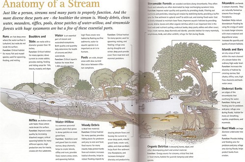 Take a handful of the sandy sediments along
the river. Rub them between your fingers. Look at them
under a magnifier (if you must, take some home where you can find a
magnifier). Are the grains coarse or fine? Are they
angular and sharp or rounded and polished? What does this
tell you about the environment these sands came from? Do you
think these sand grains were eroded from larger rocks in the
mountains to the west? Or do you suspect that they have a
different source? Considering our proximity to the coast, do
you think these sand grains could come from a beach
environment?
Take a handful of the sandy sediments along
the river. Rub them between your fingers. Look at them
under a magnifier (if you must, take some home where you can find a
magnifier). Are the grains coarse or fine? Are they
angular and sharp or rounded and polished? What does this
tell you about the environment these sands came from? Do you
think these sand grains were eroded from larger rocks in the
mountains to the west? Or do you suspect that they have a
different source? Considering our proximity to the coast, do
you think these sand grains could come from a beach
environment?
Look at the image of a generalized river to the
right1. It describes the many features you will
see (or will be unable to see) on this river. In case you're
unable to read the print on the image (you can enlarge it by
clicking on it), I'm including the relevant points below.
- Runs are fast deep areas where the water surface is
turbulent, but rocks do not break the surface.
- Riffles are shallow areas with faster flows where rocks
break the surface.
- Improves water quality by increasing dissolved oxygen, creates
silt-free substrates.
- Boulders and Slabs are rocks with a diameter greater
than 10 inches.
- Critical habitat for many species; slows current to create
eddies; provides resting, feeding, and hiding areas for fish,
insects, mussels, and algae.
- Water is an essential part of stream and watershed
ecosystems. Both quality and quantity help determine the
health of streams and their watersheds.
- High flows flush out fine sediments
-
Pools are wide, deeper areas with slow current
that occur between riffle-run complexes.
-
Woody Debris is dead tree material.
-
Helps protect banks from soil erosion; helps to reduce
flooding impacts by slowing stream flows and forcing the current to
scour deep pools, rebuild gravel beds; create runs, eddies, and
clean sandbars; helps flush fine sediment into floodplains.
-
Streamside Forests are wooded corridors along
streambanks. They often flood and naturally are often
dominated by large overhanging sycamore trees [note: sycamores are
uncommon in East Texas. What common native species serve this
purpose here?]
-
Improve water quality and quantity by providing shade,
filtering out nutrients and pesticides, reducing soil erosion by
stabilizing banks, providing a buffer area for fine sediment in
upland runoff to settle out, and storing flood water that is slowly
released to maintain base flows; improves aquatic habitats by
providing woody debris, leaves, and other organic detritus which is
an important link in the food web and nutrient cycling, undercut
banks, deep pools, eddies, and other cover; helps create narrow,
deep channels and islands; provides habitat for many mammals,
amphibians, birds, and other wildlife; refuge for fish during
floods.
- Meanders are bends in stream channels. They are
naturally formed as streams flow through floodplains.
- Helps reduce downstream flooding by using the energy of water
to create longer streams with more erosional and depositional
areas; increases the quantity and quality of stream habitats.
- Islands and Bars are dry areas of land within the main
channel of a stream below the ordinary high water level.
- Create narrow, fast chutes, riffles, runs, high flow channels
and backwater areas.
- Undercut Banks are edges of the streambanks that
overhang the water.
- Habitat for many species of wildlife
- Root Wads are large diameter underwater tree roots.
- Help protect banks from erosion.
To log this Earthcache, please submit
the following in an e-mail to me entitled "GC2H0WF: Down on the
Bayou":
- Which channel is the new river channel and which channel is the
old one?
- Please describe the sand in the sediments in this area.
Please include the following in your
log:
- Please take pictures of as many of the above listed river
features as you can find and label them with the correct term when
you upload them with your log.
1 Sanders, R. E., Ed. (2000). A Guide to Ohio
Streams: Ohio Chapter of the American Fisheries Society.
Columbus, Ohio, Streams Committee: Ohio Chapter of the American
Fisheries Society.