 |
|
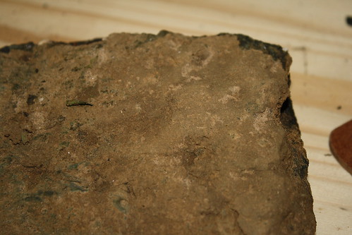
Weathered Weches rocks
|
 |
|
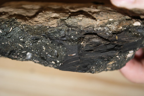
Freshly exposed surface - note the
many small fossils
|
This Earthcache brings you to a prominent outcropping of the Weches
Formation. You can find the geologic map covering this area
published by the Texas Water Development Board here.
The Weches Formation is a member of the Claiborne Group from the
Eocene epoch (~45 million years old) in the East Texas
Embayment. It is a sedimentary layer with a large amount of
variability, but it is composed of glauconitic* muds and
greensands, and brown clays and lies between the Queen City and the
Sparta Sand Formations. Marine fossils are abundant within this
formation. In this portion, the formation is mostly composed of
interbedded silts and clays with some fine-grained sands. It ranges
in thickness from 110 to 240ft thick, and it is estimated that the
sediments formed in seawater of approximately20°C.
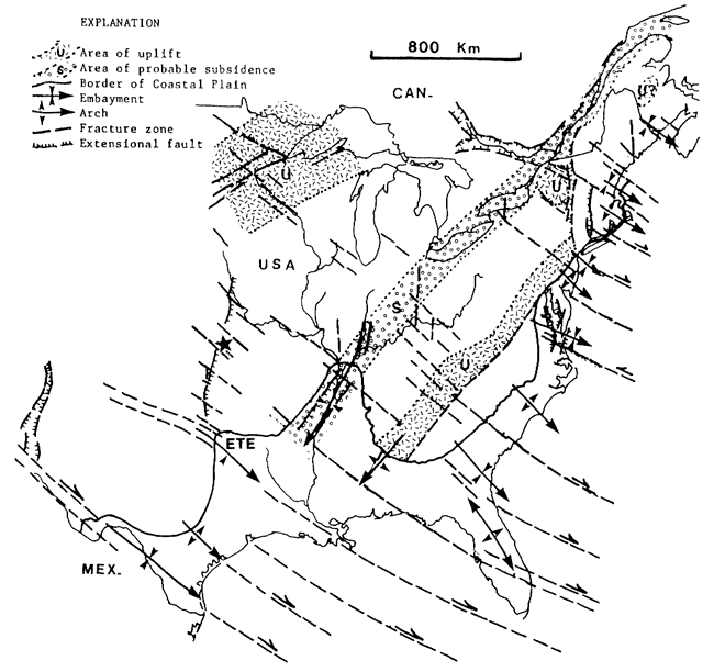
ETE = East Texas Embayment - a historical bay just West of the
Mississippi Embayment illustrated in the above map by the
indentation in the coastal plain. A more detailed explanation
of the East Texas Embayment is beyond the scope of thie Earthcache,
but the details closely parallel those regarding the Mississippi
Embayment. Suffice to say that the border of the coastal
plain illustrated in the above map illustrates how far inland the
coastline actually was prehistorically at various points.
The Weches serves as an impermeable layer between the Sparta and
Queen City sands, both of which may contain groundwater usable from
wells.
Worth noting, rocks from the Weches Formation weather into
alkaline soils of the Trawick and Nacogdoches series. This is
unique in the Pineywoods because most soils have an acidic quality
to them. The carbonate minerals in the fossils are
significant contributors to the alkaline soils. Soils
comprised of weathered Weches rocks support a few endemic
(occurring nowhere else) plant species. Lesquerella
pallida (white bladderpod) and Leavenworthia texana
(Texas golden glade cress) are two notable endemic plants that can
be found in Weches Formation soils. These two species are not
currently known on this site, however.
Rocks in the Weches Formation contain high levels of Arsenic
(up
to 122 mg/kg compared to a global average of 13 mg/kg
also here) that can be toxic.
Arsenic is common in marine sediments because it substitutes for
sulfur in the mineral pyrite. Oxidation of arsenic-bearing
pyrite produces acid sulfate conditions, precipitated
Fe(OH)3 and oxidized arsenic. Arsenic adsorbs (sticks)
to Fe(OH)3 which is transported to reservoirs by streams
and incorporated into the sediment. Be careful not to inhale
dust from these rocks or ingest the sediment and wash your hands
after handling any. Because arsenic adsorbs so readily to
precipitated Fe(OH)3, most of the arsenic is trapped
within the sediments at the bottom of reservoirs, which means
concentrations in the water rarely exceed the MCL (maximum
contaminant level) for arsenic in water.
The Weches also contains
averages of about 5ppm of Uranium and about 20ppm of
Thorium.
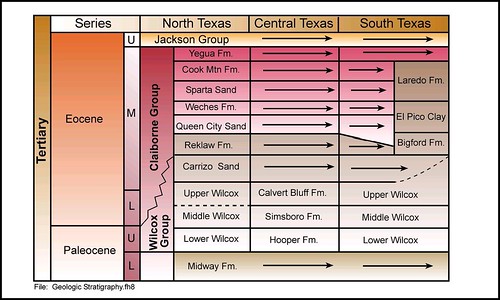
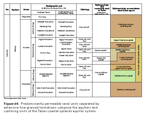
Generalized
stratigraphic section for the Wilcox and Claiborne groups in Texas
(after Ayers and Lewis, 1985; Hamlin, 1988; Kaiser, 1978; Ricoy and
Brown, 1977; Guevara and Garcia, 1972; and Payne, 1968)
*Glauconite is a mineral with a characteristic greenish color in
the mica group. It is very friable (crumbly) and has a very low
resistance to weathering. It is a characteristic mineral of marine
depositional environments.
Prior to
logging this Earthcache, please e-mail me the answers to the
following questions in a message titled "GC2GRMR: Weches
This?":
1. Measure the length of the visible outcrop of the Weches
Formation.
2. Measure the height of the outcrop.
3. What proportion of the overall formation do you suppose is
exposed here (yes, this is going to be a rough estimate since
thickness estimates of this formation vary)?
4. What is obscuring the rest?
5. Visit the following coordinates: 31.59026° N 094.83446° W How
does this outcrop differ from the other one? How do you explain
that difference?
6. Considering that the main function of Lake Nacogdoches is to
provide drinking water to the city of Nacogdoches, how to you
suppose the properties of this geological layer impact the drinking
water supply?
7. What is the EPA's Maximum Contaminant Level Goal (MCLG) for
Arsenic in drinking water?
8. What is the EPA's Maximum Contaminant Level (MCL) for Arsenic in
drinking water?
9. Please take a photo of something distinctive about this site so
I can be sure you visited it and didn't do the activities in Google
Earth.
Good information to include in your log would include any fossils
(especially if you have pictures of them) you saw exposed here, any
pictures of the site on your visit, any fossil stories you might
have, and any stories or information you might have about Arsenic
(without giving away any of the answers to the logging questions).
Pay heed to the warning signs near the dam. You do not need to pass
them.