The Needles
The Needles is a startling landscape of sculptured rock spires,
arches, canyons, grabens, and potholes.
The dominant landforms are the Needles - rock pinnacles banded in
red and white. They are located to the southwest of Squaw Flat
Campground and formed out of a resistant sandstone called Cedar
Mesa Sandstone. This layer is 245 to 286 million years old and used
to be a dune field. The red and white layers are due to coastal
dunes of white sand and floods of iron-rich debris.
Formation of the Needles
About 15 million years ago, the Colorado Plateau was pushed up
thousands of feet. Over time rivers carved deep canyons. Water is a
primary force of erosion and naturally acts faster on areas of
weakness such as fractures and cracks. The Needles occur in an area
with many fractures. Those fractures are called Joints.
Joints
Definition: A fracture dividing a rock into two sections that
have not visibly moved relative to each other.
All rocks are traversed more or less completely by vertical or
highly inclined divisional planes. Joints vary in many ways, as in
sharpness of definition, in the regularity of their course or in
number and in the directions of their intersections.
Joints are invisible - they are just planes of potential weakness -
until revealed by the slow disintegrating effects of the weather,
which induces fracture along their planes in preference to other
directions in the rock. It is along the same planes that a rock
breaks most readily under the blow of a hammer.
The number of joints in a mass of rock varies within wide limits.
Joints can be separated by intervals of several yards (little
disturbance) or rocks can be so jointed (considerable movement of
the Earth) that they acquired a fissile character.
The continual state of movement in the crust of the earth is the
primary cause of the majority of joints.
Tectonic Joints
Tectonic joints are formed during deformation episodes whenever the
differential stress is high enough to induce tensile failure of the
rock.
Unloading Joints
Joints are most commonly formed when uplift and erosion removes the
overlying rocks thereby reducing the compressive load and allowing
the rock to expand laterally. Joints related to uplift and
erosional unloading have orientations reflecting the principal
stresses during the uplift.
Cooling Joints
Joints can also form via cooling of hot rock masses, particularly
lava, forming cooling joints, most commonly expressed as vertical
columnar jointing.
On exposed surfaces joints have great influence in determining the
rate and type of weathering. They furnish an effective lodgment for
surface water, which, frozen by lowering of temperature, expands
into ice and wedges off blocks of the rock. The more numerous the
joints the more rapidly does the action proceed.
Druid Arch
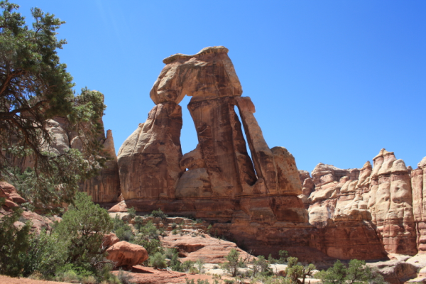
Druid Arch is one of the bigger Arches in the Park. It has a
unique form that blends into the overall view of the Needles
District.
Druid Arch is named so for its resemblance to the large standing
rocks of Stonehenge.
How to get there
Druid Arch can be reached by different hiking routes. The most
common are Squaw Canyon, Big Spring Canyon and Elephant
Canyon.
You can do a loop or go out the same way as you went in.
Conditions are primitive!
Hiking review
I started at the Squaw Flat Campground Parking Lot.
The first 1.1 miles into Squaw Canyon is pretty flat and a "trail"
is visible. There was a rain storm the day before I hiked there and
I got my feet a little wet once. There are some sign posts along
the way but taking a map is mandatory.
The trail gets interesting during the next 4.7 miles as you start
to have some elevation changes. You'll need to climb steep grades
that are dangerous when wet, jump over a little fault and squeeze
through a narrow gap. Oh and there's also a ladder you need to
climb.
The last 2.5 miles are along and in a riverbed. Only the last bit
of the way offers even another hiking experience. On my way out I
went back the 2.5 miles and then entered Elephant Canyon. The next
1.4 miles offers spectacular views. There's also another
ladder.
In order to get back to the car I went the 3.5 miles back to the
Squaw Flat Campground Parking Lot.
All in all the hike was 15.7 miles!
There is the possibility to obtain a back country permit and camp
at designated camp sites along the way.
 Whichever way you choose: BE SAVE!
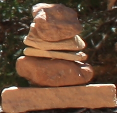
*Always stay on the trail which is marked by rock
cairns.
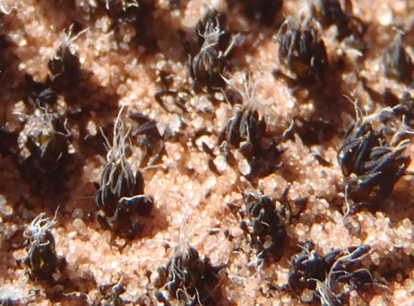
*Stay off fragile cryptobiotic crust! It is a living
community of lichens and cyanobacteria that plays a vital
ecological role.
Before you go:
! Be sure you are in good physical condition. Oh, and you
shouldn't be afraid of heights.
! Take plenty of water and have a good spare, especially during
summer. (1 gallon per day per person)
! Take along a hat or other form of protection against a sunstroke.
Use sunscreen! There are only a few shady spots along the way.
Don't forget your sunglasses.
! Take along enough food. The hike will take a while.
! Be sure to go early.
! Be prepared. Take along a first aid kit and a flashlight. Note
that cell phones might not work along the trail. Hike with a group
or tell someone where you plan to go.
! Take along a map of the Area. Know where you're going.
! Follow cairns closely. Always keep the last cairn in mind so you
can retrace yourself back when in doubt. Cairn markings sometimes
make subtle but significant directional changes. Never disassemble
a cairn!
! Check the weather. Flash floods are dangerous.
Logging requirements:
Send me a note with:
1. The text "Druid Arch" on the first line
2. The number and names of people in your group.
3. Your estimation of the height of the Arch
4. Your description of the very last part of the way and how you
think it was created
5. Order the following definitions to the ones in the description
above:
(a) Tension-joints are the most widely spread; they are naturally
most numerous over areas of upheaval.
(b) A minor cause of tension-jointing is shrinkage, due either to
cooling or to desiccation.
(c) Compression-joints are generally associated with the more
intense movements which have involved shearing.
Optional: Please post a picture of your favorite spot.
Please Note:
* You must answer all the questions in your email to me and post
your picture with your log. Do not post your answers in your
log!
* Your logging this cache and sending me the email should happen at
around the same time.
* Logs that do not meet all the above requirements will be
deleted.
Placement approved by the Canyonlands
National Park
Sources:
geology
of the needles
definition of
joints (among others)
plan
your hike