Deutsch (english below):
Das Ruhrgebiet ist Teil des europäischen
Steinkohlengürtels, der vom südlichen Polen (Katowice) über Belgien
und Nordfrankreich bis nach Mittelengland (Birmingham) reicht und
auf Grund seines umfangreichen Kohlevorkommen Ausgangspunkt für
große Montanreviere war.
Das Ruhrtal selbst gehört zum nördlichsten Teil des Rheinischen
Schiefergebirges. Dieses heute längst abgetragene Faltengebirge ist
aus Gesteinen des Erdaltertums, dem Paläozoikum (vor 544 –
249 Millionen Jahren), aufgebaut. Hier hat sich die Ruhr durch
Erosion über 100 m tief in die Auffaltungen
„gegraben“.
In diesem Bereich liegt auch die GeoRoute Ruhr, die sich quer
durch den GeoPark Ruhr zieht.
Weitere Informationen unter: GeoPark
Metropole Ruhr
Im Ruhrtal sind an der Oberfläche überwiegend Sandsteine,
Schluffsteine, Tonsteine und Kohleflöze aus dem Oberkarbon (vor rd.
320 - 296 Mio. Jahren) aufgeschlossen. Es sind die als
Steinkohlengebirge bezeichneten Gesteinsablagerungen (Sedimente),
die in einem etwa 10 Millionen Jahre andauernden Zeitabschnitt
während dieser Zeit entstanden sind. Sie umfassen ein ca. 4 km
mächtiges Schichtenpaket mit mehr als 300 Torfschichten, aus denen
die wenige Zentimeter bis teilweise 6 m dicken Kohleflöze
hervorgingen. Die einzelnen Kohleflöze gehören jeweils einem etwa
10 m dicken Gesteinszyklus (Cyclothem) an, der häufig aus der
Schichtenfolge
Sandstein-Tonstein-Wurzelboden-Kohle-Tonstein-Sandstein besteht.
Der Sandstein entstand aus im Fluss abgelagertem Sand, der Tonstein
ging aus feinstem Tonschlamm in benachbarten Flussauen hervor, der
Wurzelboden und die Kohle sind Ablagerungen eines ehemaligen Moors
und der über der Kohle liegende Tonstein stammt aus Ablagerungen
von Seen und zeitweiligen Meeresüberflutungen. Die Sedimentation
eines einzelnen Cyclothems nahm in etwa 30000 Jahre in
Anspruch
In der folgenden Abbildung (Quelle: GeoRoute Ruhr, 2010) sind die
Zeitalter zu sehen, in denen die einzelnen Aufschlüsse im Ruhrtal
entstanden sind.

Die einschneidendste Änderung der Landschaft im heutigen Ruhrtal
begann vor etwa 310 Millionen Jahren im Oberkarbon. Das bis dahin
vorherschende Meer hatte sich weiter nach Norden zurückgezogen und
das Gebiet des heutigen Ruhrtals wurde von der variscischen
Gebirgsbildung erfasst. Die ehemals horizontal liegenden
Gesteinsschichten wurden dabei - wie beim Zusammenschieben einer
Tischdecke - zu einer Reihe von FaItenzügen aufgeschoben. Die
FaItenachsen verlaufen hier meist von Südwest nach Nordost. So
entstehen die vielfältigsten Faltenformen: runde, spitze und sogar
kofferförmige Falten mit unterschiedlichsten Längen von wenigen
Zentimetern bis zu mehreren Kilometern.
In der folgenden Grafik ist die in diesem Zeitraum (vor ca. 310
– 320 Millionen Jahren) entstandene Schichtenfolge des
Steinkohlengebirges im Ruhrgebiet dargestellt. Die dabei
entstandenen Kohleflöze sind als schwarze Linien dargestellt. Die
gelben Linien stellen die Sandsteinformationen dar:
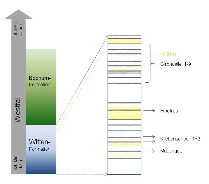
Neben dem Parkplatz an den obigen Koordinanten sind in der
Böschung mehrere dünne Flöze und Sandsteinbänke zu sehen. Sie
gehören zur sogenannten Girondelle-Gruppe der Witten Formation. Die
Witten-Formation ist eine Mulde im niederrheinisch-westfälischen
Becken, die am Nordrand von Kreide bedecke ist und am Südrand
teilweise zu Tage tritt. Die Girondelle-Gruppe ist eine Folge von
mehreren Sedimentschichten in der Witten-Formation, die von 9
Kohleschichten den Girondellen 1 – 9 durchzogen werden. Sie
liegt im oberen Bereich der Formation. An der durch die Koordinaten
beschriebenen Stelle ist die an die Oberfläche getretene
Schichtenfolge gut zu erkennen. Die Mächtigkeit der Kohleschichten
ist in dieser Gruppe so gering, dass sich ein Abbau nicht
lohnt.
Um diesen Earthcache zu loggen beantworte die folgenden Fragen und
sende die richtigten Buchstaben der Antworten zu den vier Fragen an
folgende Adresse: hcdv-ec-1x2x3x4x@t-online.de
(Beispiel: richtige Antworten sind 1a, 2b, 3c und 4d =
hcdv-ec-1a2b3c4d@t-online.de).
Bitte gebe im Betreff Deinen Geocaching-Namen ein, damit wir Deine
Antwort zuordnen können.
Wenn die Antworten richtig sind erhältst Du umgehend die
Logfreigabe.
Logs ohne Freigabe werden ohne Rückfrage gelöscht.
- Wie breit ist das am nord-östlichen
Ende der Girondelle sichtbare Kohleflöz?
a) < 20 cm
b) 20 - 50 cm
c) 50 - 75 cm
d) > 75 cm
- Welche Farbe (neben dem Schwarz der Kohle) ist hier an mehreren
Gesteinsschichten zu sehen?
a) rot
b) gelb
- Wie hoch sind die im Ruhrtal übereinanderliegenden
Sedimente?
a) ca. 300 m
b) ca. 3000 m
c) ca. 4000 m
- In welchem Erdzeitalter entstand die hier zu sehende
Formation?
a) Tertiär
b) Oberkreide
c) Oberkarbon
d) Mitteldevon
Ein Foto von Dir/Deinem GPS-Geräte vor der Girondelle-Formation
im Log wäre schön.
English (deutsch oben):
The Ruhr Valley is part of the european
anthracite (black) coal belt, reaching from South-Poland (Katowice)
across Belgium and Northern France until Middle-England
(Birmingham), being the point of origin for large coal-mining
districts because of its wide coal deposits.
The Ruhr Valley itself belongs to the most northern part of the
„Rheinisches Schiefergebirge“. This folded mountain,
eroded long ago, is composed of stones of the Paleozoic (544
– 249 Millionen years ago). At this place the Ruhr eroded
itself more than 100 m through the folds.
In this area the GeoRouteRuhr is located, crossing the GeoPark
Ruhr.
For more informations see: GeoPark
Metropole Ruhr
In the Ruhr Valley sandstones, siltstones, mudstones and coal seams
from the Upper Carboniferous (320 - 296 Mio. years ago) are
predominantly laid open. It were the sediments called „black
coal mountains“ that arised in a period of 10 million years.
They contain a layer package, which is more than 4 km thick, with
more than 300 layers of peat, from which emerged the coal seams
with a thickness from a few centimeters up to 6 meters. The
separate coal seams belong to a stonecycle (cyclothem) with a
thickness of approx. 10 meters, consisting of a layer sequence
„sandstone-mudstone-rootsoil-coal-mudstone-sandstone“.
The sandstone arised from sand sedimented in the river, the
mudstone arised from finest clay mud from the nearby flood plains,
the root soil and the coal are sediments of an ancient swamp and
the mudstone above the coal arises from sediments of lakes and
temporary oceanic floodings. The sedimentation of a single
cyclothem took about 30.000 years.
In the following illustration (Source: GeoRoute Ruhr, 2010) you can
see the periods, in which the separate outcrops in the Ruhr Valley
arised.
The most radical change of the landscape in the Ruhr Valley begun
approx. 310 million years ago in the Upper Carboniferous. The
predominat ocean retired to the north and the area of today’s
Ruhr Valley has been captured by the variscic orogenesis. The
layers of stone, formerly lying horizontally, have been moved
upward to a couple of folds - like pushing a tablecloth together.
The axes of the folds run from south-west to north-east. By this
way the varied forms of the folds arised: round, pointed and
case-formed folds with a lenght from a few centimeters up to
several kilometers.
The following illustration presents the layer sequence of the
black coal mountains in the Ruhr Valley, that arised in this period
(approx. 310 – 320 million years ago). The coal seams, that
arised in this process, are presented by black lines. The yellow
lines are sandstone formations.
Next to the parking area at the coordinates above you can see
several small seams and sandstone banks at the hillside. They
belong to the so called Girondelle group of the Witten-formation.
The Witten-formation is a dell in the lowerrhinian-westfalian
basin, which is covered with chalk at the north side and emerges at
the south side. The Girondelle group is a sequence of several
sediment layers in the Witten-formation, which is crossed by nine
coal seams called Girondelle 1 – 9. They are lying in the
upper area of the formation. At the listed coordinates you can see
the layer sequence coming to the surface. The thickness of the coal
layers is too low for mining.
For to log this earth cache answer the following questions and
send the correct alphabetic characters from the four questions to
the following adress: hcdv-ec-1x2x3x4x@t-online.de
(Example: correct answers are 1a, 2b, 3c and 4d =
hcdv-ec-1a2b3c4d@t-online.de).
Please enter your geocaching name as subject, so that we are able
to assign your answer to your log.
If your answers are correct you will receive the permission to log
immediately.
Logs without permission will be deleted without further
enquiry.
- How broad is the coal seam visible at the north-eastern end of
the Girondelle?
a) < 20 cm
b) 20 - 50 cm
c) 50 - 75 cm
d) > 75 cm
- What color (beneath the black of the coal) is visible here at
several stone layers?
a) rot
b) gelb
- How high are the sediments lying upon another in the Ruhr
Valley?
a) ca. 300 m
b) ca. 3000 m
c) ca. 4000 m
- In what geological era the formation visible here arises?
a) Tertiary
b) Upper Cretaceous
c) Upper Carboniferous
d) Middle Devonian
We enjoy a photo with you/your GPS-device in front of the
Girondelle formation in addition to your log.