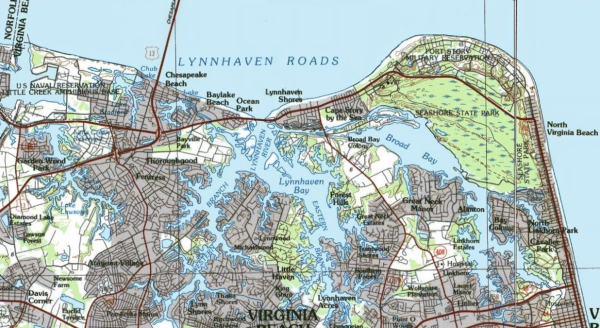
The Lynnhaven River System (LRS) is a tidal
esuary located in Virginia Beach, Va. Its inlet is located just
East of the Chesapeake Bay Bridge Tunnel and West of Cape
Henry.
There are several components that you will come across
while doing this EarthCache.
Sand - Small Granular material of finely
divided rock and mineral particles;
Clay - A very fine particle that smears easily
when pressed between the fingers. These are derived from parent
rocks chemical weathering of the minerals;
Silt - Material that is smaller than sand and
is easily placed in load in a slow stream or water system. One can
still detect the grain between the fingers;
Loam - A mixture of sand, clay, silt, and
decomposed matterials. Decomposed matterial if formed from carbon
based life. Giving the soil a blackish appearance.
Lynnhaven Beach N 36° 54.35 W 076° 05.65
Great Neck Park N 36° 53.019 W 076° 03.707
North Landing State Park N 36° 53.930 W 076° 01.46
To claim this find you must:
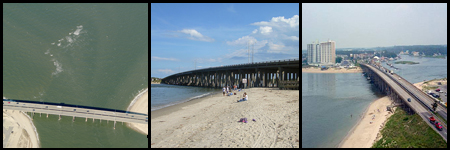
1) Upload a picture of yourself with your GPS (or just your GPS)
with the Lesner Bridge behind you. If you're using
your phone as a camera and GPS we'll settle for a picture of the
bridge.
2) Email the answers to the following questions:
a) What is another name for tidal wetlands?
b) Name the three key attributes of wetlands.
c) What did you notice about the water flow at Lynnhaven
Inlet.
d) Did you notice any beach animals anywhere else; if so why do you
think this is so?
e) How do marsh plants keep the bay clean?
3) At each location look at and examine a soil sample. Write a
short description of what you think each soil is and how this soil
type affects the local settings. Keep in mind that the soils will
be easily recgonized by picking up a piece and running it through
your fingers to feel the grains. The smoother the texture the more
clay and loam you will find. * PLEASE STAY OUT OF THE
RESTORATION AREA at site #2. If you are interested in
learning more you can go to web soil survey
The LRS is the second largest watershed in
Virginia Beach, covering 64 square miles. Once was famous for the
native oysters, which declined through both human pollution and
residential runoff. The species is now being restored by the
Lynnhaven River Now restoration project.
The U.S. Fish and Wildlife Service emphasizes three key attributes
of wetlands:
1) hydrology ( the degree of flooding or soil
saturation)
2) hydrophytes (wetland vegetation)
3) hydric soils (soil in which water has displaced
the air)
Loss and Man’s manipulation of these water ways has
occurred due, construction of drainage ditches, canals and hard
shoreline stabilization projects. One major historic problem that
has plagued the wetland of the world is the conversion of wetlands
to agriculture fields and development into plush residential
properties. The loss has led to a reduction in the sediments
ability of buffering the environment.
Here is what the city of Virginia Beach has written about the
LRS:
“Lynnhaven River Watershed
The rise in the population of coastal areas in recent years has
lead to concerns about water quality in the bays and estuaries
along the eastern seaboard. The quality of the Chesapeake Bay has
declined over the years, and approximately 20 years ago, studies
began to be commissioned to study the causes of decreased water
quality in the bay, with three primary sources being singled
out
• Increased nutrients from agricultural areas and lawns
(fertilizers)
• Increased runoff from increased numbers of paved
surfaces
• Presence of toxic chemicals.
While the adverse effects of toxic chemicals are obvious, the
other two factors may require some explanation. Increased numbers
of paved surfaces means that raindrops do not soak into the ground
and ultimately the groundwater, but instead, run off driveways and
streets, picking up oil and other contaminants along the way. This
rainwater is carried into the sewers and eventually the waterways.
Sand and silt picked up by the runoff clouds waterways, reducing
their aesthetic value and choking marine plants and animals that
need clear water and lots of sunlight to survive. Excess
fertilizers that do not soak into the ground where they are applied
will eventually promote excess algae growth in waterways, with
similar results as with other forms of increased runoff.
Implementation of programs to improve the Chesapeake Bay has
occurred, but oyster reefs, wetlands, and underwater grasses, are
still only a fraction of what they once were. In 1991, in response
to federal and state directives, the City of Virginia Beach adopted
the Chesapeake Bay Preservation Area Ordinance. The ordinance is
designed to protect existing high quality waterways, prevent
pollution counts from increasing, and restore contaminated waters
to high qualities that will both allow recreational use and promote
healthy aquatic animal and plant life. This ordinance is carried
out by strict limitations on construction within the Resource
Protection Areas (RPA), which are areas at or near shorelines
within the watershed, and encouraging natural vegetation buffers to
control runoff.
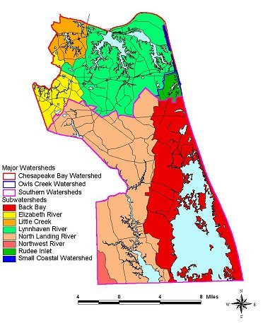
The Lynnhaven River Watershed covers almost the entire Chesapeake
Bay watershed area in Virginia Beach with the exception of the
portion covered by the Elizabeth River watershed (See below map).
The Lynnhaven River Watershed covers 51,000 acres, or approximately
1/4 of the area of Virginia Beach; of this area, 5,100 acres are
open water. The Lynnhaven River has 150 miles of shoreline.
History:?The Lynnhaven Bay and the two branches of its river have a
fascinating history. In the late 1600s pirates terrorized the
waters of the Chesapeake Bay so much that merchant ships loaded
with the abundant Virginia resources began to meet on Lynnhaven Bay
to sail as a convoy under the protection of an armed guard ship.
However, some of the guard ships were woefully outgunned by the
pirates, and the outlaws became bolder, sailing into Lynnhaven Bay
and plundering ships anchored there. One French ship, the La Paix,
under the command of Louis Guittar, looted 19 ships before finally
meeting defeat in an Englishman named William Passenger and his
ship the Shorham. Guittar and 63 of his crewman were ultimately
hanged in England for their crimes.
The Revolutionary War found Lynnhaven Bay as a crucial point for
the anchorage of a French fleet under the command of French Admiral
de Grasse. The British Navy hoped that it had the French trapped by
the narrow Lynnhaven Inlet, but the French fought fiercely and
soundly defeated the British, giving the American and French troops
control of the entrance to the Chesapeake Bay. This left General
Cornwallis, anchored at Yorktown, cut off from replenishment of
supplies. It was only five weeks after this crucial naval battle
that the British surrendered.
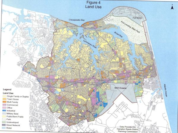
Land Use:?The primary land use in the Lynnhaven watershed is
residential. By 1990, the population of the area had topped
250,000. This makes the population density of the area one person
per 1/5 of an acre. This heavy development has lead to numerous
adverse effects on the environment, including runoff of fertilizers
and pesticides from lawns, increased animal waste, sediment runoff
from construction sites, and increased rainwater runoff from paved
surfaces such as driveways and sidewalks.
The waterways themselves are used for many recreational activities
including boating, swimming, waterskiing and jetskiing.
Unfortunately, the increased runoff into waterways has created
large deposits of sediment in the channels used by boaters, leading
to requests for dredging. The shallow waters, however, are ideal
areas for oyster reefs and fish spawning, as well as for underwater
grasses, also known as submerged aquatic vegetation (SAV), to grow.
SAV not only provides feeding grounds for birds and fish, but
filters pollutants and additional sediments flowing into the
waterways. The main stands of these underwater grasses are found in
Broad Bay, but recent years show promising signs for the
vegetation, as it has begun to spread southward into Linkhorn
Bay.
In years past, the shellfish of the Lynnhaven were enthusiastially
harvested by area fisherman who made their livelihood from the
river's bounty. However, an increase in the fecal coliform count,
measuring the amount of human and animal waste in the water, has
made the shellfish in the Lynnhaven unfit for raw human
consumption.
Other land uses in the Lynnhaven watershed include numerous
businesses along Virginia Beach Boulevard and I-264, military bases
such as Little Creek Amphibious Base, Oceana Naval Air Station, and
Fort Story. Many parks are also located in the watershed, including
62 city parks, four of which are located along shorelines, and
First Landing State Park, a 2900 acre park located in the
northeastern portion of the city and containing many wetlands, sand
dunes, hiking trails, and a mile of shoreline along the Chesapeake
Bay.
Ecological Programs:?Residents of the entire Chesapeake Bay
watershed are encouraged to participate in the BayScapes program,
which tries to control runoff through natural vegetation buffers on
private property. Additionally, residents are asked to use natural
mulches and fertilizers and minimize the use of pesticides. The
Hampton Roads Sanitation District (HRSD) and the Southeastern
Public Service Authority (SPSA) now recycle yard waste products and
sell these recycled materials as compost, mulches, and soil
conditioner and plant food supplements. These organic products are
called "Nature's Blend" and are available at area garden
centers.
With a little work to maintain water quality and prevent
degradation, we can restore the Lynnhaven to its former beauty and
productivity.”