The route is not difficult but has more than 6 km to reach
the cache from Metro Plentzia on. Following the estuary of the
Butron river, it reaches the beaches of Plentzia and Gorliz,
ascends to the lighthouse of Gorliz and the mount Ermua, offering
splendid views and all without cars, one time crossed the street
between the metrostation and the bridge.
Recomendo tomarse todo el día para disfrutar de la playa.
I recommend you to stay the whole day there to enjoy the
beach.

Se puede ir andando o en bicicleta hasta el faro. Hay gente que
sube en bicicleta al monte pero no es fácil y sobre todo en los
fines de semana los paseos estan lleno de gente. Para llegar a las
coordenadas del cache hay que contestar unas preguntas.
You can go walking or by bicycle until the lighthouse. There are
people which ascend the hill by biciycle but it's not easy. To find
the coordinates of the cache you have to respond to some
questions.
Waypoint WP01 - Estación del Metro de Plentzia, N 43°24.120', W
002°56.790'
¿Cuándo salen los trenes?
When will the trains leave?
Desde la estación del Metro de Plentzia cruzamos la ría del
Butron para llegar a Plentzia y nos dirigimos a la derecha, donde
estan las marismas de Plentzia y antiguamente habia dos molinos de
marea.
From the metro-station of Plentzia we cross the Butron river to
reach Plentzia and direct us to the right, where are the swamps of
Plentzia and formerly have been two mills using the tide.
Waypoint WP02 - Antiguo molino de marea Gazteluondo, N
43°24.173', W 002°56.713'
A:
¿Cuántas ruedas de piedra estan en la hierba?
How many mill-stones are there in the grass?
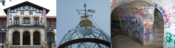
Seguimos la orilla hacia el mar y dentre poco llegamos al
ayuntamiento de Plentzia. Detras del ayuntamiento se encuentra el
frontón.
Following the riverside to the sea we soon reach the townhall of
Plentzia. Behind the townhall is the frontón.
Waypoint WP03 - Frontón, N 43°24.258', W 002°57.010'
B:
¿A qué numero refiere la última letra del ano que se puede ver
alli?
To which number relates the last letter of the year you can find
there?
Volvemos a la orilla y seguimos adelante, asi llegamos al puerto
de Plentzia donde se encuentra una estatua de la virgen.
Going back to the riverside and going forward we reach the
harbour of Plentzia, where we find a statue of the virgin.
Waypoint WP04 - Estatua de la Virgen, N 43°24.468', W
002°56.780'
C:
¿Cuántas placas hay alli?
How many signs are there?
Llegamos a la playa y seguimos adelante. Las playas han sido
remodelados y hay una piedra para recordarlo.
The beaches have been renewed and we can find a stone to
remember this.
Waypoint WP05 - Piedra, N 43°24.976', W 002°56.629'
D:
¿Quál es la suma de las cifras del acondicionamiento de las
playas?
Which is the sum of the ciphers of the fitting up of the
beaches?

Para subir al faro hay diferentes caminos, el más corto sale al
frente de la entrada del hospital de Gorliz. Es un camino bonito
desde que se ve vacas, corderos y caballos. Un poco abajo del faro
estan situadas las ruinas de una fortificación que valen la pena
visitarlas.
To ascend to the lighthouse you can take diferent ways, the
shortest one begins opposite to the entrance of the hospital of
Gorliz. It is a nice way from which one you can see lots of cows,
sheep and horses. A little bit below the lighthouse are situaded
the ruins of a fortification that are worth a visit.

Waypoint WP06 - Faro de Gorliz, N 43°26.007', W
002°56.628'
E:
¿Cuál numero aparece dos veces encima de la puerta del faro?
Which number appears two times above the door of the
lighthouse?
Desde el faro tomamos la senda que sube entre encinares costeros
remontando todo el lomo del Ermua.
From the lighthous we take the path that ascends between costal
ilex, following the hillside of the Ermua.
Waypoint WP07 - Cima del Ermua, N 43°25.915', W
002°55.659'
F:
¿Cuál es el primer digit de la altura del Ermua?
Which is the first digit of the hight of the Ermua?
Siguiendo adelante se llega a una ruina con el vertice encima
del techo. Lluego baja el camino y se llega a un cruce dónde se
puede decidir cómo volver: se puede regresar tomando la misma ruta,
seguir hasta Armintza con su bonito puerto (Bus) o bajar por
Gorliz.
Following the way you reach a ruin with a vertex on the roof.
From there on the way decends and you reach a crossing where you
have to decide how to get back: you can return on the same way, go
forward to Armintza with its nice harbour (Bus), or go down to
Gorliz.
El cache se encuentra - the cache is situated:
N CD°FB.E [C-D] F', W 00F°BB.[A-D+F] [D*F] F'