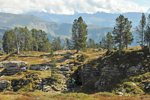
Die seit langer Zeit bekannte Seefeldhöhle liegt
etwa 1.2 km südöstlich der Siebenhengste. Sie ist neben der St.
Beatushöhle die einzige frei und leicht zugängliche Höhle in der
grossen Höhlenregion Hohgant-Siebenhengste. Ihre Ausdehnung beträgt
gegen 1000m. Der Name Tropfloch weist auf früher vorhandene
Tropfstein- und Sinterformationen hin. Leider wurden diese
inzwischen meist weggeschlagen. Wie die St. Beatushöhle ist sie
nicht mit dem grossen Höhlensystem verbunden.
Im Gegensatz zu den andern Höhlen der Region liegt
das Tropfloch vollständig im eozänen Sandstein, welcher hier eine
Mächtigkeit von etwa 100m hat.
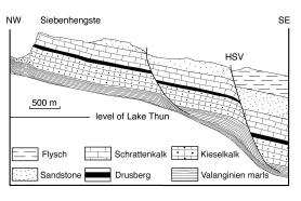
Der Sandstein bildet drei Stockwerke, wobei das
oberste und unterste aus verkarstetem Kalzitzement und das mittlere
aus undurchlässigem quarzitischem Zement besteht. Auf der mittleren
Schicht haben sich die Moore des nahe gelegenen Wagenmoos gebildet.
Das Tropfloch befindet sich in der untersten Schicht, welche eine
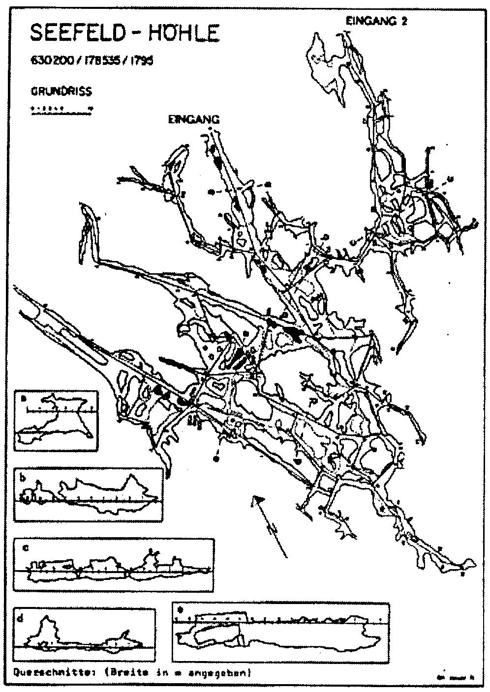
Mächtigkeit von etwa 20m hat. Die Höhle ist labyrinthartig
aufgebaut und hat mehrere Längsgänge, die durch Quergänge verbunden
sind. Alle Gänge liegen jedoch auf einer Ebene. Vom Eingang senkt
sich die Höhle leicht gegen Süden ab.
Die Hauptgänge sind zwischen
1.6 und 2.1 m hoch, die Quergänge meist tiefer. Grosse Hallen gibt
es keine. Dafür ist die Höhle weitgehend trocken. Ein genauerer
Plan findet sich unten bei den
Bildern.
Eine Besonderheit ist die
ausgedehnt vorkommende Mondmilch, eine flächige weiss bis beige, meist
kalzitische Ablagerung auf dem Fels, deren Genese bis heute noch
nicht genau geklärt werden konnte. Gebildet wird sie aus
mikrokristallinen bis nanokristallinen Koagulaten unregelmässiger,
teilweise strahliger Individuen. Sie ist viskos und porös, trocknet
nie ganz aus und kann bis zu 3cm dick werden. Nahe der
nordspanischen Stadt Aia gibt es in der Alzolahöhle sogar einen
Fluss aus Mondmilch! Erstmals erwähnt als lac
lunae wurde sie 1555 durch Konrad Gesner im
Zusammenhang mit dem Mondmilchloch am Pilatus. Etymologisch stammt
der Name jedoch von Mandlimilch (-> Erdmannli) ab und hat
eigentlich nichts mit dem Mond zu tun. Gemäss Funden wurde
Mondmilch in der Schweiz schon zur Bronzezeit und bis 1900 auch in
der Seefeldhöhle gesammelt, da man ihr Heilwirkung
gegen Sodbrennen
und Muttermilchmangel
zuschrieb.
Sicherlich muss die Höhle schon sehr lange bekannt gewesen
sein. So berichtet
eine Sage, dass unter der Seefeldhöhle eine
zweite, viel grössere liege, die einen wunderbaren Schatz berge.
Tatsächlich liegt ja darunter das grosse Enwässerungssystem des
Siebehengste-Hohgant-Réseaus.
Zugang:Die Seefeldhöhle kann gut von Habkern über
Wanderwege via WP1 N46° 45.212 / E007°
50.450 Mittleres Seefeld erreicht werden. Die Höhle steht unter
Naturschutz, ist jedoch frei zugänglich. Es ist wichtig, genug
Licht und zudem sinnvoll, einen Plan und eventuell einen Kompass
mitzunehmen. Wie bei allen Höhlenbegehungen raten wir von einem
Alleingang ab. Kinder in Begleitung von Erwachsenen können die
Höhle jedoch gut besuchen. Wenn man nach dem Höhlenbesuch etwa 200m
Richtung Nordwest den Hang gegenüber hinaufgeht, hat man eine
schöne Sicht auf das Wagenmoos und die
Siebenhengste.
Logbedingung:
Bevor du den Cache loggen kannst beantworte
uns folgende Fragen per Mail:
-
Beschreibe, wie sich die Mondmilch anfühlt (du
brauchst nicht davon zu kosten!) und welchen Farbton du
siehst.
-
Wie breit und wie hoch ist die Höhle an der engsten
Stelle am Eingang?
-
Wie lang
ist die Höhle gemäss Schild beim
Eingang?
Mach ein Foto von einer Stelle mit Mondmilch, und
falls dies nicht möglich ist, vom Höhleneingang. Natürlich darfst
du auch auf dem Foto sein. Nach der Logerlaubnis füge dieses Bild
deinem Log bei.
English Version
The Seefeldhöhle lying about 1.2 km southeast of the
Siebenhengste is well known since a long time. Along with the St.
Beatus Cave it's the only easily accessible cave in the large cave
region of Hohgant-Siebenhengste. The Tropfloch has an extension of
almost 1000m. Its name points to former dripstone and sinter
formations. Unfortunately most of them were destroyed. Like the St.
Beatus Cave it is not connected to the large cave
system.
Contrary to the other caves in the region the
Tropfloch is completely lying in eocene
sandstone, which has a massiveness of about 100 m here
(see cross section above).
The sandstone is forming three layers, the
top and bottom one having calcareous consistence, the middle one
being of impermeable quartziferous consistence. This layer gave
origin to the nearby swamps of Wagenmoos. The Tropfloch is lying in
the bottom stratum having a massiveness of about 20 m. The cave has
a maze-like form and is built of several
longitudinal galleries,
connected by crossing
galleries. But
all of them are lying on the same plane. The cave slightly slopes
down southward from the entrance (see map above). The main
galleries are between 1.6 and 2.1m high, the crossing galleries are
mostly lower. There are no large halls but the cave is widely dry.
A detailed map you will find down among the
pictures.
A peculiarity of the cave is the extensive
occurance of Mondmilch (moon milk), a flat white-beige calcareous
deposit on the rock whose origin has not yet been fully cleared. It
is built by microcrystalline to nanocrystalline coagulates of
irregular and partially radial individuals. The substance is
viscous and porous, never drying completely and having a thickness
up to 3cm. Near the northern Spanish town Aia there even exists a
river of Mondmilch flowing through the Alzola cave! Konrad Gesner
first mentioned it in 1555 as lac lunae
relating to the Mondmilchloch at the Pilatus.
Etymological references confirm that Mondmilch originated from the
designation Mandlimilch (manmilk → milk from the good folk)
and is not related to the moon. According to archeological findings
Mondmilch was collected in Switzerland since the Bronze age and
until 1900 as well in the Seefeldhöhle for curing heartburn and
lack of mothers milk. But the cave must have been known for a much
longer time. A legend is telling about a giant cave underneath
containing a marvellous treasure. In fact the drainage system of
the Siebenhengste-Hohgant-Réseau is lying
there.
Access:The best
access to the Seefeldhöhle is by marked trails from Habkern to WP1
N46° 45.212/ E007° 50.450 Mittleres Seefeld. The cave is under
protection but free for visiting. It's important to have enough
light with you. Further it is advisable to take a map and maybe a
compass with you. It's recommendable not to enter the cave alone.
But children accompanied by adults may easily visit it. After
visiting the cave it's worthwhile ascending the opposite hill for
about 200 m direction northwest. From there you will have a
splendid view over the Wagenmoos and to the
Siebenhengste.
Logging
conditions: Before logging
you have to answer the following questions by a
mail:
-
Describe how it does feel to touch the Mondmilch
(You don't have to taste it!) and which shade of colour it
has.
-
How wide and tall is the cave at the smallest point
of the entrance?
-
How long is the cave according to
the plaque at the entrance?
Make a photograph of a spot with Mondmilch or if
this is not possible one of the cave entrance. If you like you may
be on this picture too. After having received permission to log add
the photograph to your log.