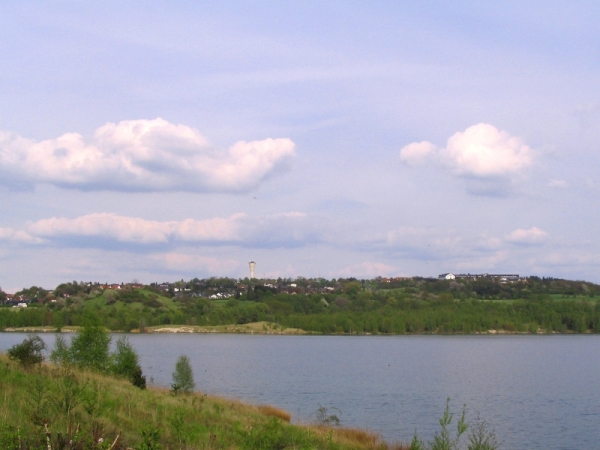
Der Borkener See liegt in der westhessischen Senke und ist für
dieses Gebiet ein wichtiger Rastplatz für Zugvögel. Die
Wasseroberfläche liegt etwa 177 m über NN. Die Fläche des Sees
beträgt ca. 139 ha. Seine Länge ist ca. 1250 m und die Breite
ca.780 m. An den See grenzen die Stadt Borken und die Stadtteile
Nassenerfurth und Trockenerfurth.
Entstehung der Braunkohle
Braunkohle ist ein bräunlich-schwarzes, meist lockeres
Sedimentgestein, das durch Druck und Luftabschluss von organischen
Substanzen entstand. Braunkohle ist ein fossiler Brennstoff, der
zur Energieerzeugung verwendet wird.
Hauptentstehungszeit der Braunkohle ist in Deutschland das
Tertiär. In anderen Ländern kann Kohle in wesentlich älteren
Formationen angetroffen werden, die in ihren physikalischen und
chemischen Eigenschaften der Braunkohle ähneln.
Wie bei der Steinkohle spielt auch hier das organische Material
abgestorbener Bäume, Sträucher und Gräser eine Rolle, welches nach
der Überdeckung mit verschiedensten Sedimenten unter Druck und
Luftabschluss den geochemischen Prozess der Inkohlung
durchlief.
Entstehung des Borkener Sees
Hervorgegangen aus dem ehemaligen Braunkohletagebau Grube Altenburg
IV entstand im Zuge der Rekultivierung von 1975 bis 1992 der
Borkener See. Bei Untersuchungen zu Beginn der Füllung stellte sich
jedoch heraus, dass der See leicht basisch und zudem oligotroph
war. Daraufhin wurde von der Beschleunigung der Füllung abgesehen
und die Ausweisung des Borkener Sees als Naturschutzgebiet
eingeleitet.
Feuchtbiotop
Zudem wurde im Norden des Braunkohle-Tagebaus ein Feuchtbiotop
mitca. 5 ha Fläche angelegt. Besonderer Wert wurde auf eine
langeUferlinie mit ca. 1,3 km Länge, bei gerade einmal 2,6 ha
Wasserfläche, gelegt.
Wasserqualität
Anders als die meisten größeren Seen in Hessen ist der Borkener See
oligotroph. Auch ist durch seine Größe nicht damit zu rechnen, dass
er eutroph wird. Des Weiteren weist er im Gegensatz zu ähnlichen
Tagebauseen in ihrem "Jugendstadium" einen basischen pH-Wert
auf.
Hydrologische Daten
Das Einzugsgebiet des Borkener Sees beträgt etwa 350 ha
einschließlich der Seefläche mit 139 ha. Sein Volumen umfasst
35.000.000 m³. Der Borkener See wird durch Schichtquellen des
Buntsandstein mit 72 l/s (=104 m³/täglich) gespeist. Der pH-Wert
schwankt zwischen 7,5 und 9.
Um zu loggen beantworte bitte folgende
Fragen:
1. Wie ist die max. Wassertiefe ?
2. Was ist der Unterschied zwischen
oligotroph– eutroph ?
3. Buntsandstein ist eigentlich kein bestimmter
Gesteinstyp, was ist er dann ?
4. Wieviele Tiere zählst du hier auf der
Schautafel ?
5. Aus welchem hauptsächlichem Material ist die
Infotafel vor Ort und was für eine geometrische Form hat sie ?
Bitte mache ein Foto von dir oder deinem GPS. Foto von dir ist
keine Bedingung, vom GPS schon.
Es darf sofort geloggt werden, wenn etwas nicht stimmt, melde ich
mich schon.
--------------------------------------------------------------------------------------
The Borkener lake is located in the west Hessian valleys and
forthis area it is an important stopover for migratory birds. The
water surface is about 177 m above sea level. The area of the lake
is about 139 ha. Its length is about 1250 m and the width about 780
m. Near to the sea are the city of Borken and the districts
Nassenerfurth and Trockenerfurth.
Formation of brown-coal
Brown coal is a brownish-black, usually loose sedimentary rock,
which is arisen from high pressure exclusion of air of organic
substances. Brown coal is a fossil fuel, which is used for the
energy production.
Main time of origin of the brown coal is in Germany the Tertiary
period. In other countries coal can be found in substantially older
formations, which resemble the brown coal in their physical and
chemical characteristics.
As is the case for the hard coal the organic material of died
trees, bushes and grasses plays also here a role, which went
through the geochemical process of so called "Inkohlung" after the
cover with most diverse sediments under pressure and exclusion of
air.
Formation of the Borkener Sea
Formed by the former opencast lignite mine "Altenburg IV" the
Borkener Lake was created as part of the reclamation from 1975 to
1992. In studies at the beginning of the filling turned out that
the lake was slightly alkaline and oligotrophic also. Was then
apart from the acceleration of the filling and introduced the
designation of Borkener lake as a nature reserve.
Wetlands
Moreover, in the north of the brown coal mine created a wetland
area with about 5 hectares. Special emphasis was placed on a
longshoreline with about 1.3 km in length, at just 2.6 ha of
watersurface.
Water Quality
Unlike most major lakes in the Hessian area the Borkener Lake is
oligotrophic. Also, its size is not likely to be eutrophic. In
addition, it has, in contrast to similar mining lakes in their
"youth stage" a basic pH-value.
Hydrological data
The drainage area of the Borkener Lake is about 350 hectares
including the lake area with 139 ha. Its volume is 35 million m³.
The Borkener Lake is fed by layer sources of the brownstone at 72
l/ s (= 104 m³ / day). The pH-value varies between 7.5 and 9
Please answer following questions to log this
cache:
1. What is the max. Water depth?
2. What is the difference between oligotrophic - eutrophic?
3. Red sandstone is not really a certain type of rock, what is
it?
4. How much animals you can count on the infoboard ?
5. Please take a picture from you or your GPS. Picture from you is
not required but from your GPS and is helpful to see that you visit
the place.
You can log your visit immediately. When something ist wrong I will
give you an information.