

Come on a journey to remember and commemorate
the history and travels of Captain John
Smith!
Over four
hundred years ago, Englishman John Smith and a small crew set out
in an open boat to explore the Chesapeake Bay. Between 1607 and
1609 Smith mapped and documented nearly 3,000 miles of the Bay and
its rivers. Along the way he visited many thriving American Indians
communities and gathered information about this “fruitful and
delightsome land.” In December 2006 the U.S. Congress
designated the routes of Smith’s explorations of the
Chesapeake as a national historic trail—the first national
water trail.
Are you ready
to follow in the wake of Captain John Smith? Visit sites along the
National Historic Trail and learn about the native cultures and the
natural environment of the 17th-century Chesapeake through the
Captain John Smith Chesapeake Geotrail. The Trail provides
opportunities for you to experience the Bay through the routes and
places associated with Smith’s explorations. Caches will be
located in museums, refuges, parks, and towns in Virginia, Maryland
and Delaware along the rivers and creeks that Smith and his crew
explored four centuries
ago.
The Captain
John Smith (CJS) Geotrail launched June 4, 2011 with over 40 caches
within Maryland, Virginia and Delaware. A trackable geo coin will
be awarded to the first 400 geocachers, while supplies last, for
locating at least 15 CJS caches. To be eligible for the coin,
geocachers must download a passport from either the CJS Geotrail or Maryland Geocaching Society website.
Geocachers must find and log at least 15 finds, record the code
word from each cache on their passport and post a picture of
themselve at each cache location. After discovering the 15 required
caches, geocachers may have thier passports validated in person or
via mail at the National Park Service, Chesapeake Bay Office
located at 410 Severn Ave, Suite 314, Annapolis, MD 21403. Please
refer to the passport for complete validation instructions.
Participating in the CJS geotrail is fun and we hope that many
people join in. However, it is not a requirement for logging your
find on this cache once you find the container.
You are seeking a traditional hide. A Lock & Lock stocked with
a variety of items. Cache was placed with special permission so
please follow all park rules and no night caching!
Important: Parking is only available from East Bound Clara
Barton Parkway. N38 58.293, W77 09.636. Coming FROM the east, turn
around at the Carderock (David S Taylor) Naval Surface Warfare exit
just outside the Beltway.
This facility is free of charge. The River Center at Lock #8 is
open weekends from May 1 to the end of October from 10am until 2pm.
The C&O Canal is open during daylight hours only. The cache is
available even if the nearby River Center house is closed.
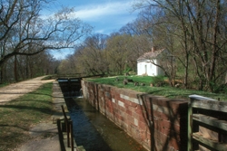
Photo Courtesy of Potomac
Conservancy
The River Center at Lockhouse 8 was established via a partnership
between the Potomac Conservancy and the National Park Service in
2001. Open on the weekends from May to October, the River Center
River provides visitors the opportunity to learn more about the
history, ecology, and diversity of the Potomac River, through
exhibits, docent tours, and seasonal events. In addition, the
Potomac Conservancy also hosts a variety of hands-on appreciation
and restoration activities at the River Center. All activities are
free and open to the public.
Located along the C&O Canal towpath, the River Center at
Lockhouse 8 was originally built in 1830 to provide shelter for the
Lockkeeper and his family. Lockhouse 8 played a vital role in the
operation of the C&O Canal as a primary transportation route
along the Potomac River. Lock 8 is the first of the series of locks
known as "Seven Locks," which raise the Canal 56 feet over the
distance of one and a quarter miles. Solomon Drew, the first keeper
of Lock 8, was paid $100 per year. In the early 1900s, canal
operations ended and the Lockhouse was abandoned, and the building
remained closed until it was re-opened as the River Center at
Lockhouse 8.
While Smith did not document each day the Potomac River journey in
detail, his writings reflect that the shallop Discovery sailed as
far up-river as the Little Falls of the Potomac. As one primary
purpose of the voyage was to search for potential minerals or other
valuable resources, the crew was eager at the prospect of the
interesting geology that they found in this region of the Potomac.
Securing the shallop, the crew of Englishmen took samples of rocks
found near Little Falls and continued to explore the area near the
river on foot. A short distance from the river, the crew found
spangled layers of gilded soils, which Smith documented. The gilded
soil that Smith described in his writing was likely mica-rich
sediments common today at this location.
The crew continued to hike above the river to look for silver,
gold, or other precious minerals and Smith also documented that
they found “a clay sand so mingled with yellow spangles as if
it had been half pin-dust.” Doubting the likelihood of
finding potential for productive mines, the crew headed back to the
shallop and returned downriver, heading back towards Jamestowne
after spending a month and a half aboard the shallop.

Thanks to
CPHug for helping with this hide and to
the Maryland Geocaching Society for assisting with this
project!