

Come on a journey to remember and commemorate the history and travels of Captain John Smith!
Over four hundred years ago, Englishman John Smith and a small crew set out in an open boat to explore the Chesapeake Bay. Between 1607 and 1609 Smith mapped and documented nearly 3,000 miles of the Bay and its rivers. Along the way he visited many thriving American Indians communities and gathered information about this “fruitful and delightsome land.” In December 2006 the U.S. Congress designated the routes of Smith’s explorations of the Chesapeake as a national historic trail—the first national water trail.
Are you ready to follow in the wake of Captain John Smith? Visit sites along the National Historic Trail and learn about the native cultures and the natural environment of the 17th-century Chesapeake through the Captain John Smith Chesapeake Geotrail. The Trail provides opportunities for you to experience the Bay through the routes and places associated with Smith’s explorations. Caches will be located in museums, refuges, parks, and towns in Virginia, Maryland and Delaware along the rivers and creeks that Smith and his crew explored four centuries ago.
The Captain John Smith (CJS) Geotrail launched June 4, 2011 with over 40 caches within Maryland, Virginia and Delaware. A trackable geo coin will be awarded to the first 400 geocachers, while supplies last, for locating at least 15 CJS caches. To be eligible for the coin, geocachers must download a passport from either the CJS Geotrail or Maryland Geocaching Society website. Geocachers must find and log at least 15 finds, record the code word from each cache on their passport and post a picture of themselve at each cache location. After discovering the 15 required caches, geocachers may have thier passports validated in person or via mail at the National Park Service, Chesapeake Bay Office located at 410 Severn Ave, Suite 314, Annapolis, MD 21403. Please refer to the passport for complete validation instructions.
Participating in the CJS geotrail is fun and we hope that many people join in. However, it is not a requirement for logging your find on this cache once you find the container.
You are seeking a traditional hide. The cache is a bison tube. This park is only open sunrise to sunset. Please no night caching!
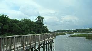
Photo Courtesy of P. L. Fallin
Overlooking the Nanticoke River and Tangier Sound, Roaring Point Park offers a quiet and peaceful retreat along the Eastern Shore of Maryland. The amenities Roaring Point Park offers include prime opportunities for fishing or crabbing, quiet stretches for beach walking, and convenient access to local opportunities for camping. The park is located near the Chesapeake Country Blue Crab Byway with access to a wealth of historic, cultural and natural resources that distinguish Maryland's Lower Eastern Shore as a rural region.
From earliest time, life on the Lower Eastern Shore has linked to the Atlantic Ocean, the Chesapeake Bay and tributaries, and the marshes and land between. Compelling evidence of past peoples and cultures reverberates throughout the various corners of the region. The seafood industry and agriculture have long formed the backbone of the lower shore economy and sustained a way of life built on the resources of land and water. A number of factors have adversely affected these traditional industries over the past decade, decreasing the economic base of the area and threatening its rich heritage.
Near the mouth of the Nanticoke River, the location Roaring Point Park is likely near where the crew of the shallop Discovery anchored their barge for their first night in the Nanticoke. From some scenic overlooks of the Nanticoke River, a contemporary visitor can imagine the view Nanticoke Indians had of the English barge sailing up the river. Upon initial entry into the river, the English were greeted with arrows of suspecting local tribes, so the dropped anchor out of range.
The next day, after another ambush shortened attempt to trade goods and information, Smith eventually left trade goods on the northern bank of the river. The crew spotted smoke off the bank opposite bank, and after landing they saw two or three houses that probably composed a summer fishing camp of Nause. The residents had fled, so Smith left good for trade with the absent American Indians, before returning to the river to explore and then anchor yet again.
Spotting smoke rising from beyond the bank (or smelling smoke on a windy day) was often the best way to identify an American Indian town location from the river, because homes tended to blend in with the surroundings. Whether covered with bark or with mats, their outer shells were brown or dun-colored when new and graying when weathered. Typical homes would blend in with deciduous trees and shrubs in winter and were shielded from view by foliage in summer.
Even today, there are many places along the Nanticoke River that maintain a landscape view that is evocative of how the landscape appeared from the water to the shallop crew over 400 years ago. Many of these landscapes also still retain cultural and natural resources that are associated with the historic lifestyle and settlement patterns associated with American Indian peoples of the period.
 Thanks to The 9 Searchers for helping with this hide and to the Maryland Geocaching Society for assisting with this project!