Come on a journey to remember and commemorate
the history and travels of Captain John
Smith!
Over four
hundred years ago, Englishman John Smith and a small crew set out
in an open boat to explore the Chesapeake Bay. Between 1607 and
1609 Smith mapped and documented nearly 3,000 miles of the Bay and
its rivers. Along the way he visited many thriving American Indians
communities and gathered information about this “fruitful and
delightsome land.” In December 2006 the U.S. Congress
designated the routes of Smith’s explorations of the
Chesapeake as a national historic trail—the first national
water trail.
Are you ready
to follow in the wake of Captain John Smith? Visit sites along the
National Historic Trail and learn about the native cultures and the
natural environment of the 17th-century Chesapeake through the
Captain John Smith Chesapeake Geotrail. The Trail provides
opportunities for you to experience the Bay through the routes and
places associated with Smith’s explorations. Caches will be
located in museums, refuges, parks, and towns in Virginia, Maryland
and Delaware along the rivers and creeks that Smith and his crew
explored four centuries ago.
The Captain
John Smith (CJS) Geotrail launched June 4, 2011 with over 40 caches
within Maryland, Virginia and Delaware. A trackable geo coin will
be awarded to the first 400 geocachers, while supplies last, for
locating at least 15 CJS caches. To be eligible for the coin,
geocachers must download a passport from either the CJS Geotrail or Maryland Geocaching Society website.
Geocachers must find and log at least 15 finds, record the code
word from each cache on their passport and post a picture of
themselve at each cache location. After discovering the 15 required
caches, geocachers may have thier passports validated in person or
via mail at the National Park Service, Chesapeake Bay Office
located at 410 Severn Ave, Suite 314, Annapolis, MD 21403. Please
refer to the passport for complete validation instructions.
Participating in the CJS geotrail is fun and we
hope that many people join in. However, it is not a requirement for
logging your find on this cache once you find the container.
The cache is NOT at the listed coords. Please no night
caching!
Please park at the listed coordinates. You will need to answer some
questions about the structure nearest the parking coords.
A = number of windows (Do NOT count the glass at the top of the
door as a window.)
B = number of chimney(s)
C = number of characters (NOT just letters) in the name above
door
DEFG = year the building was built
TUV = (A times C) + D + E + F
XYZ = ((A + B) times C) + D + E + E + F
To find the final North cache coordinate ADD TUV to the last 3
digits of the listed North coordinate.
To find the West cache coordinate ADD XYZ to the last 3 digits of
the listed West coordinate.
Checksum for cache coordinates is 61.
While in Trap Pond you may want to consider doing Delaware’s
oldest cache, dElAWare 7{1} (GC10A).
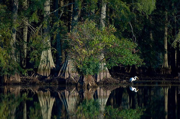
When at Trap Pond State Park, the smart visitor will rent a canoe
or kayak and paddle around the pond, getting a low-to-the-water
view of turtles sunning on logs and meanders around the pond
through baldcypress trees. If you don’t want to do the
paddling yourself, Trap Pond State Park offers pontoon boat tours
on the weekends, or you can use their boat ramp to launch your own
small motorized boat.
Freshwater wetlands once covered a large portion of southwestern
Sussex County. Trap Pond State Park retains a part of the swamp's
original beauty and mystery, and features the northernmost natural
stand of baldcypress trees in the United States. The pond was
created in the late 1700s to power a sawmill during the harvest of
large baldcypress from the area. The Federal Government later
purchased the pond and surrounding farmland during the 1930s and
the Civilian Conservation Corps began to develop the area for
recreation. Trap Pond became one of Delaware's first state parks in
1951.
Baldcypress is a long-lived, important tree in a swampland
ecosystem. It was a valuable source of lumber, prized for its
durability and resistance to rot. Baldcypress is known for its
“knees”, cone-shaped extensions of the root system
thought to function as the trees’ means of obtaining oxygen
for the roots during flooded conditions.
American Indians favored baldcypress for their log canoes, some of
which could accommodate nearly 40 people. Baldcypress was highly
favored by English boat builders as well. By 1607, when Captain
John Smith began exploring the Chesapeake, most forests in England
had been cut and timber became a very important export. In his
writings, Smith reported seeing baldcypress trees eighteen feet in
circumference at the base. These very large, very straight trees
were a valuable commodity, and the Virginia Company of London
expected Captain Smith and his fellow Jamestown settlers to find
suitable timber in addition to precious metals and the hoped-for
Northwest Passage providing easy access from the Atlantic Ocean to
the other side of the world for trade.
Camping: For visitors who wish to stay overnight, there are 142
campsites (tents and recreational vehicles can be accommodated).
Yurts and Camping Cabins may also be available.
Daily Entry Fees: A park entrance fee is charged daily from March 1
to November 30. This fee allows your vehicle and its passengers to
enter any Delaware State Park on the date of purchase, except for
Fort Delaware and Brandywine Zoo. Delaware Registered Vehicle: $3
per day at Trap Pond, Out-of-state Registered Vehicle: $6 per day
at Trap Pond. Hours: Trap Pond is open daily from 8 a.m. to
sunset.
Other considerations: Dogs must remain leashed and are NOT allowed
in picnic areas. A Map of Trap Pond is available for downloading
and printing:
http://www.destateparks.com/downloads/maps/trap-pond/trap-pond-2009.pdf

Thanks to Hostanut for helping with this hide and to the
Maryland Geocaching Society for assisting with this project.
Delaware State Park
Approved.