

Come on a journey to remember and commemorate
the history and travels of Captain John
Smith!
Over four
hundred years ago, Englishman John Smith and a small crew set out
in an open boat to explore the Chesapeake Bay. Between 1607 and
1609 Smith mapped and documented nearly 3,000 miles of the Bay and
its rivers. Along the way he visited many thriving American Indians
communities and gathered information about this “fruitful and
delightsome land.” In December 2006 the U.S. Congress
designated the routes of Smith’s explorations of the
Chesapeake as a national historic trail—the first national
water
trail.
Are you ready
to follow in the wake of Captain John Smith? Visit sites along the
National Historic Trail and learn about the native cultures and the
natural environment of the 17th-century Chesapeake through the
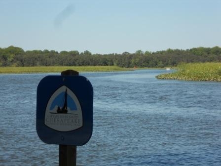
Captain John Smith Chesapeake Geotrail. The Trail provides
opportunities for you to experience the Bay through the routes and
places associated with Smith’s explorations. Caches will be
located in museums, refuges, parks, and towns in Virginia, Maryland
and Delaware along the rivers and creeks that Smith and his crew
explored four centuries
ago.
The Captain John Smith (CJS) Geotrail launched June 4, 2011 with
over 40 caches within Maryland, Virginia and Delaware. A trackable
geo coin will be awarded to the first 400 geocachers, while
supplies last, for locating at least 15 CJS caches. To be eligible
for the coin, geocachers must download a passport from either the
CJS Geotrail or Maryland Geocaching Society website.
Geocachers must find and log at least 15 finds, record the code
word from each cache on their passport and post a picture of
themselve at each cache location. After discovering the 15 required
caches, geocachers may have thier passports validated in person or
via mail at the National Park Service, Chesapeake Bay Office
located at 410 Severn Ave, Suite 314, Annapolis, MD 21403. Please
refer to the passport for complete validation instructions.
Participating in the CJS geotrail is fun and we hope that many
people join in. However, it is not a requirement for logging your
find on this cache once you find the container.
Phillips Landing Recreation Area is located near the confluence of
the Nanticoke River and Broad Creek. Phillips Landing is CLOSED
DUSK TO DAWN EXCEPT FOR FISHING. Please no night caching!
Phillips Landing is adjacent to the Nanticoke Wildlife area. This
area is open for hunting. Access to this cache is allowed on
SUNDAYS ONLY from SEPTEMBER 1ST to FEBRUARY 15TH each year, AND
during SPRING WILD TURKEY SEASONS. Hunting Season information can
be found at WWW.FW.DELAWARE.GOV.
In May of 2007 a monument was placed at Phillips Landing Recreation
Area to commemorate Captain John Smith’s exploration of the
Nanticoke River. The listed cords will take you to this monument
located in the middle of the parking area but the actual cache is
located in the Nanticoke Wildlife Area. On your way to the cache,
you may want to stop at N 38° 33.778 W 075° 40.269 to visit an old
small Phillips cemetery. Use this monument to decipher the puzzles
below to determine the last 3 digits of the North and West coords
of the final cache.
SUBTRACT the answer to the puzzle below from the last 3 digits of
the appropriate listed coord.
North:
| 5-3-7 |
12-6-1 |
6-2-4 |
15-4-8 |
10-3-2 |
| 6-4-5 |
9-5-4 |
5-4-2 |
14-4-1 |
2-6-4 |
West:
| 14-8-2 |
8-4-8 |
3-5-7 |
16-4-5 |
6-4-7 |
13-5-8 |
| 3-5-2 |
10-7-1 |
13-2-10 |
7-4-6 |
2-5-8 |
11-3-5 |
Checksum for cache coordinates is 60.
Phillips Landing Recreation Area is a popular fishing and
recreation spot on the Nanticoke River at the confluence of Broad
Creek. It is a favorite spot for largemouth bass anglers and hosts
numerous bass tournaments. It’s also a popular spot for
launching a canoe or kayak to follow the Nanticoke River Water
Trail.
The vessel used by Captain John Smith to explore the Chesapeake and
rivers was a shallow-draft boat called a “barge” or
“shallop”. Likely brought along on the voyage from
England, it was built and stored on the ship in two sections that,
in a matter of days, could be fitted together and used for
localized exploration. It could be sailed or rowed depending on the
circumstances, was approximately 30 feet long and could carry two
to three tons of cargo. It was open to the weather but either a
tarp, or one of its two sails, could provide cover.
In June, 1608, Captain Smith and his crew aboard the Discovery
Barge ran into a bad storm near present-day Bloodsworth Island. The
day was ending and the powerful storm ripped away the mast and
foresail, and the crew had to bail to keep the shallop from being
swamped. For the next day and a half, Smith and his men stayed on
the island, which they named “Limbo” for the troubles
they suffered with a damaged boat and a lack of drinking water. The
tailor among the group was able to mend the sail using the cloth
from the men’s shirts. It is unknown whether the original
mast was recovered or if a new one had to be made.
After the necessary repairs, the Discovery Barge and her crew
sailed or rowed up the Nanticoke River to a mixed reception by the
local inhabitants, the Nanticoke Indians. Within another day, Smith
made it as far as Broad Creek off the Nanticoke, where present day
Phillips Landing offers launching of recreational watercraft and
the surrounding Nanticoke Wildlife Area conserves landscapes that
appear much as they did 400 years ago.

Thanks to Hostanut for helping with this hide and to the Maryland
Geocaching Society for assisting with this
project!