 For 100 years, the National Park Service has preserved America’s special places “for the enjoyment, education, and inspiration of this and future generations.” Celebrate its second century with the Find Your Park GeoTour that launched April 2016 and explore these geocaches placed for you by National Park Service Rangers and their partners.
geocaching.com/play/geotours/findyourpark


Come on a journey to remember and commemorate the history and travels of Captain John Smith!
Over four hundred years ago, Englishman John Smith and a small crew set out in an open boat to explore the Chesapeake Bay. Between 1607 and 1609 Smith mapped and documented nearly 3,000 miles of the Bay and its rivers. Along the way he visited many thriving American Indians communities and gathered information about this “fruitful and delightsome land.” In December 2006 the U.S. Congress designated the routes of Smith’s explorations of the Chesapeake as a national historic trail—the first national water trail.
Are you ready to follow in the wake of Captain John Smith? Visit sites along the National Historic Trail and learn about the native cultures and the natural environment of the 17th-century Chesapeake through the Captain John Smith Chesapeake Geotrail. The Trail provides opportunities for you to experience the Bay through the routes and places associated with Smith’s explorations. Caches will be located in museums, refuges, parks, and towns in Virginia, Maryland and Delaware along the rivers and creeks that Smith and his crew explored four centuries ago.
The Captain John Smith (CJS) Geotrail launched June 4, 2011 with over 40 caches within Maryland, Virginia and Delaware. A trackable geo coin will be awarded to the first 400 geocachers, while supplies last, for locating at least 15 CJS caches. To be eligible for the coin, geocachers must download a passport from either the CJS Geotrail or Maryland Geocaching Society website. Geocachers must find and log at least 15 finds, record the code word from each cache on their passport and post a picture of themselve at each cache location. After discovering the 15 required caches, geocachers may have thier passports validated in person or via mail at the National Park Service, Chesapeake Bay Office located at 410 Severn Ave, Suite 314, Annapolis, MD 21403. Please refer to the passport for complete validation instructions.
Participating in the CJS geotrail is fun and we hope that many people join in. However, it is not a requirement for logging your find on this cache once you find the container.
The posted coordiantes of this letterbox hybird, will bring you to the beautiful Watermens Museum. This cache contains a specially crafted stamp created by QOCMike. The container is a camo'd Lock & Lock which contains a logbook, letterbox stamp, pre-stamped index cards, and small Capt. John Smith Trail items.
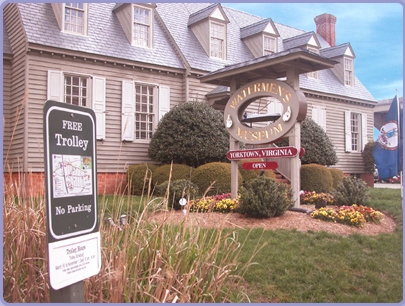
Located on the shore of the York River in the Tidewater’s Historic Triangle, the Watermen’s Museum is dedicated to preserving the Chesapeake Bay’s fishing and boating culture and to innovative environmental education. Their mission is to demonstrate the role that Chesapeake Bay watermen played in the shaping of our nation through a historical display of crafts and methods of their trade. Thanks in part to a grant from the Chesapeake Bay Gateways and Watertrails Network, a replica hand-carved canoe such as the Pamunkey Indians used in the 17th century is being constructed with the help of the Pamunkey Indian tribe. The canoe will complement traditional Chesapeake Bay boat-building activities and museum exhibits that explain the colonial through modern watermen’s culture of Virginia.
The York River was originally known as the Pamunkey, after the tribe that lived off the river and surrounding lands. Descendants of Powhatan’s tribes still fish for shad here each spring and operate shad hatcheries on both the Pamunkey and the Mattaponi Indian Reservations. Their ancestors were essential in ensuring the survival of the original English colonists, trading them some of the corn that kept the settlers alive.

Thanks to QOCMike for helping with this hide and to the Maryland Geocaching Society for assisting with this project!