

Come on a journey to remember and commemorate the history and travels of Captain John Smith!
Over four hundred years ago, Englishman John Smith and a small crew set out in an open boat to explore the Chesapeake Bay. Between 1607 and 1609 Smith mapped and documented nearly 3,000 miles of the Bay and its rivers. Along the way he visited many thriving American Indians communities and gathered information about this “fruitful and delightsome land.” In December 2006 the U.S. Congress designated the routes of Smith’s explorations of the Chesapeake as a national historic trail—the first national water trail.
Are you ready to follow in the wake of Captain John Smith? Visit sites along the National Historic Trail and learn about the native cultures and the natural environment of the 17th-century Chesapeake through the Captain John Smith Chesapeake Geotrail. The Trail provides opportunities for you to experience the Bay through the routes and places associated with Smith’s explorations. Caches will be located in museums, refuges, parks, and towns in Virginia, Maryland and Delaware along the rivers and creeks that Smith and his crew explored four centuries ago.
The Captain John Smith (CJS) Geotrail launched June 4, 2011 with over 40 caches within Maryland, Virginia and Delaware. A trackable geo coin will be awarded to the first 400 geocachers, while supplies last, for locating at least 15 CJS caches. To be eligible for the coin, geocachers must download a passport from either the CJS Geotrail or Maryland Geocaching Society website. Geocachers must find and log at least 15 finds, record the code word from each cache on their passport and post a picture of themselve at each cache location. After discovering the 15 required caches, geocachers may have thier passports validated in person or via mail at the National Park Service, Chesapeake Bay Office located at 410 Severn Ave, Suite 314, Annapolis, MD 21403. Please refer to the passport for complete validation instructions.
Participating in the CJS geotrail is fun and we hope that many people join in. However, it is not a requirement for logging your find on this cache once you find the container.
This fun multi/puzzle cache will lead you through Preservation Virginia. This cache is only available during business hours. Please respect all park property. The posted coordinates will bring you to a sign along the parking lot. This puzzle is a simple, multiple choice question. Select the correct answer and you will find the cache.
If the sign describes:
A – John Smith’s arrival – then go 220 feet north and look at the base of an oak.
B – The Civilian Conservation Corps – then go 220 feet east and look under a false rock.
C – Indian Culture before the settlers’ arrival – then go 220 feet southeast and look under pine needles at the base of the fence.
D – The Chesapeake Bay Gateways Network – then go 220 feet west and look inside the museum store.
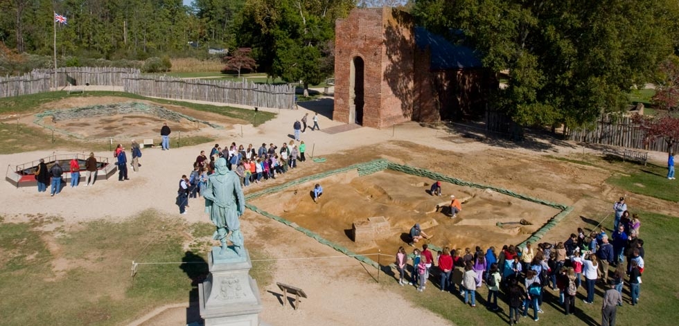
The mission of Historic Jamestowne is to preserve, protect, and promote the original site of the first permanent English settlement in North America and to tell the story of the role of the three cultures, European, North American and African, that came together to lay the foundation for what became the United States of America. Since 1893, the Association for the Preservation of Virginia Antiquities, now known as Preservation Virginia, has preserved the 22.5 acres on which a seventeenth century church tower and the original James Towne fort stood. Preservation Virginia is the oldest statewide historic preservation organization in the country and manages 23 historic properties across the Commonwealth of Virginia.
More than a decade of on-going archeological excavation has unearthed millions of artifacts, housed in a new museum. This work has offered new and compelling insights into life during the early years of the Jamestown settlement. Several signet rings, armor, wine bottles and seals, coins, and other items confirm the presence of various gentleman and suggest the style of living to which the wealthy were accustomed. The marks of earthfast structures in the 400-year-old soil outline the buildings within the fort, confirming written descriptions. The bones of horses, dogs, rats, snakes, and turtles attest to the desperation of the Starving Time during the winter of 1609-10, when nearly all of the 160 colonists perished, trapped in the by the angry Powhatan Indians with woefully insufficient supplies.
It was from the first James Fort that John Smith launched his exploratory voyages in 1607-08, mapping approximately 3,000 miles of the Chesapeake Bay and most of its major tributaries, meeting with numerous Indian tribes, and documenting the flora and fauna. The map Smith made, his leadership of the colony during its darkest days, and his descriptions of the natural abundance of the Chesapeake Bay region ensured the colony’s survival by attracting new immigrants and investment, strengthening the tenuous foothold of the English in North America.

Thanks to QOCMike for helping with this hide and to the Maryland Geocaching Society for assisting with this project!