
Come on a journey to remember and commemorate the history and travels of Captain John Smith!
Over four hundred years ago, Englishman John Smith and a small crew set out in an open boat to explore the Chesapeake Bay. Between 1607 and 1609 Smith mapped and documented nearly 3,000 miles of the Bay and its rivers. Along the way he visited many thriving American Indians communities and gathered information about this “fruitful and delightsome land.” In December 2006 the U.S. Congress designated the routes of Smith’s explorations of the Chesapeake as a national historic trail—the first national water trail.
Are you ready to follow in the wake of Captain John Smith? Visit sites along the National Historic Trail and learn about the native cultures and the natural environment of the 17th-century Chesapeake through the Captain John Smith Chesapeake Geotrail. The Trail provides opportunities for you to experience the Bay through the routes and places associated with Smith’s explorations. Caches will be located in museums, refuges, parks, and towns in Virginia, Maryland and Delaware along the rivers and creeks that Smith and his crew explored four centuries ago.
The Captain John Smith (CJS) Geotrail launched June 4, 2011 with over 40 caches within Maryland, Virginia and Delaware. A trackable geo coin will be awarded to the first 400 geocachers, while supplies last, for locating at least 15 CJS caches. To be eligible for the coin, geocachers must download a passport from either the CJS Geotrail or Maryland Geocaching Society website. Geocachers must find and log at least 15 finds, record the code word from each cache on their passport and post a picture of themselve at each cache location. After discovering the 15 required caches, geocachers may have thier passports validated in person or via mail at the National Park Service, Chesapeake Bay Office located at 410 Severn Ave, Suite 314, Annapolis, MD 21403. Please refer to the passport for complete validation instructions.
Participating in the CJS geotrail is fun and we hope that many people join in. However, it is not a requirement for logging your find on this cache once you find the container.

Your are seeking a traditional hide. This park is open 7 days per week from dawn to dusk with an entrance fee of $2.00/$3.00. Please refer to the park website for complete details. Please no night caching!
Located in rural Surry County, Chippokes Plantation, now a Virginia State Park, was one of the first plantations in Virginia and has been farmed continuously since 1617. Named for Choupocke, an Indian chief friendly to English settlers, Chippokes Planation’s early owners included Governor Sir William Berkeley, who acquired the property in 1671, and the Ludwell family, who owned the property from 1684 to 1824.
Chippokes is situated just across the James River from Jamestown Island. Now a National Park, Jamestown Island is the site of the first permanent English settlement in North America. English colonists arrived in 1607, gradually gaining a foothold in the new environment and eventually displacing native communities to make way for European-style farming.
The James and other rivers explored by John Smith in 1607-1609 were populated by thousands of Virginia Indians. The rivers offered not only abundant fish and shellfish but also transportation between settlements. After the English arrived, the rivers served the same purposes, although dugout canoes gradually gave way to barges and ships. Plantations like Chippokes were situated close to rivers, often on the sites of abandoned Indian villages, both for their fertile soil and to more easily allow hogsheads of tobacco to be traded for cargoes of flour, wine, and other goods.
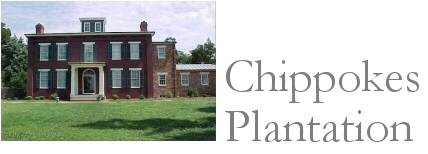
Today, Chippokes Plantation State Park offers tent camping, guest cabins, and a variety of outdoor activities. The park has 3.5 miles of hiking and bicycling trails, a half-mile of which is accessible to people with physical disabilities, through the historic area, as well as an auto farm tour road. The park also has an equestrian area with about 10 miles of riding fun available around farm fields as well as two long, multiple-use trails. Visitors can tour the 1855 Italianate mansion (pictured above), as well as the Farm and Forestry Museum, surrounded by a variety of cultivated gardens and native woodland. A canoe launch offers access to the James River, where even a short paddle can reveal a variety of native wildlife.
 Thanks to SeePaulGolf for helping with this hide and to the Maryland Geocaching Society for assisting with this project!