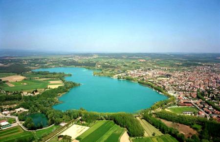
L'Estany de Banyoles representa la massa d'aigua continental més gran de Catalunya, amb un gran valor paisatgístic i mostra d'identitat col·lectiva. A nivell científic es pot considerar un llac (sinònim d’estany, però de dimensions més grans), tot i que el topònim oficial del lloc i el nom utilitzat pels habitants de la zona és el d’Estany de Banyoles. És el segon llac natural més extens de la península Ibèrica, després del de Sanabria (Zamora), que és d’origen glacial. L'Estany és un llac d’origen tectònic i càrstic
Origen i formació:
Per definició un sistema càrstic està caracteritzat per processos de dissolució de roques calcàries i de guix per l’acció de l’aigua infiltrada al subsòl, generant un relleu determinat. El tret característic de les àrees càrstiques és la circulació subterrània de les aigües. Entre els punts d'infiltració de l’aigua i els de sortida, la circulació s'estableix aprofitant els punts febles de la capa de roques i dóna origen a un sistema de cavitats, pous i galeries on l'aigua, escolant-se lliurement o a pressió, genera processos d'erosió i de dissolució.
 El funcionament del sistema càrstic de la conca lacustre de Banyoles pot resumir-se en uns quants fets encadenats. Les aigües de pluja infiltrades a la zona de l’Alta Garrotxa, alimenten un aqüífer que circula subterràniament –un riu subterrani- vers el sud pels materials calcaris que son permeables. Aquesta aigua subterrània sorgeix a superfície per la pressió del sistema que provoca que l’aigua ascendeixi a través d’escletxes i fissures dels materials geològics en sentit vertical fins sortir a la superfície en forma de surgències. Amb el temps el pas de l’aigua que ascendeix des de les roques calcàries del subsòl cap a la superfície va dissolent els guixos de las capes intermèdies creant cavitats o forats que en enfonsar-se a superfície i omplir-se d’aigua provoquen la formació d’estanyols.
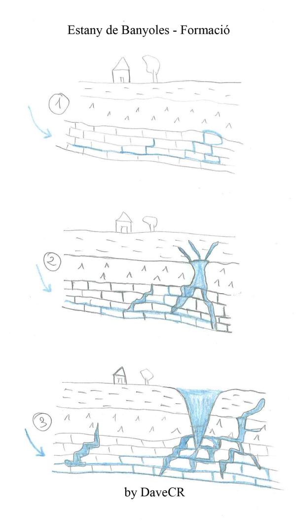 El funcionament del sistema hidrogeològic s’explica no només per aquest origen càrstic, sinó també per un origen tectònic. La falla d’Albanyà que circula pel costat est de la conca lacustre delimita un canvi de materials geològics, de manera que la capa de calcàries per on circula l’aqüífer no té continuïtat més enllà de Banyoles, i es troba una capa de margues, materials impermeables, que provoquen un augment de pressió del sistema obligant a l’aigua a sortir de forma vertical a través d’escletxes i fissures fins alimentar els estanys, estanyols, fonts i bullidors. Els bullidors, sinònim de surgència o brollador, són punts per on l’aigua sorgeix amb força de forma intermitent barrejada amb l’aire acumulat a sota terra, creant la sensació d’aigua bullint.
Durant el procés de dissolució dels diversos materials s’originen cavitats cada vegada més grans fins que el terreny cedeix i l’aigua surt a l’exterior. El relleu de l’Estany està dibuixat per 6 cubetes o grans enfonsaments, el fons d'algunes de les quals es troba ocupat per un volum considerable de llot en suspensió, que impedeix copsar l'estructura en embut que les caracteritza. És així com es va formar el llac i els estanyols fa uns 250.000 anys.
Pregunta nº1:
Quin nom geològic reben aquestes cubetes o grans enfonsaments que es formen pel colapse del sostre de les grans cavitats creades per l’aigua?
Superficialment l’estany té una forma allargada assimilable a un número 8. Al fons de l'Estany de Banyoles s'hi ha localitzat fins a 13 punts sorgents principals d’aigua, que totalitzen una alimentació subterrània d’entre 400 i 600 l/s (uns 40.000 m3 diaris d’aigua). El conjunt d'entrades d'aigua superficial i subterrània, renoven continuadament el volum de l'Estany. El temps de renovació total d'aquest llac és superior als 200 dies.
Importancia del llac
La zona lacustre de l’estany conté el registre més complert de la història geològica quaternària del nord-est peninsular. Constitueix un dels pocs exemples mundials que permeten analitzar els processos de sedimentació actuals relacionats amb la dinàmica lacustre i aplicar-ho a dipòsits antics dins la mateixa zona. També constitueix un dels millors exemples de carst actiu i el seu impacte en la utilització del sòl.
Els afloraments geològics pleistocens han proporcionat una fauna de mamífers fòssils molt variada que estan perfectament conservats i exposats al Museu Arqueològic Comarcal de Banyoles. És per tot això que aquesta geozona (zona d’interès geològic definida per la Generalitat de Catalunya) pot considerar-se com una de les millors aproximacions al coneixement del Quaternari a Catalunya.
La Pedra de Banyoles
L'Estany de Banyoles i els estanyols que es troben a les seves rodalies constitueixen l'àrea sorgent de més baixa cota del sistema hidrogeològic. La seva conca, en forma aproximada d’amfiteatre, actua com a àrea de recepció superficial. Sis són les principals rieres que vessen les seves aigües a l'Estany, fonamentalment pel seu marge oest, i alguns altres els recs menors que drenen cap a aquest l'aigua d'algunes fonts, estanyols o camps de conreu. L’aigua de les rieres i la que entra subterràniament omplen l’estany i mantenen un nivell més o menys estable. Uns canals artificials que s'anomenen "recs", construït pels monjos benedictins de Banyoles a partir del segle IX serveixen per desguassar l’aigua de l’Estany cap al riu Terri.
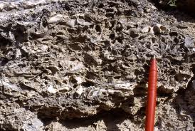
A més dels recs hi ha dos col·lectors subterranis que serveixen per buidar l’Estany en previsió de pluges intenses i eviten el seu desbordament, i cal sumar-hi també l’aigua que s’extreu de l’estany per a consum humà. Antigament l’Estany es buidava formant un sobreeixidor natural i inundant tota la plana de Banyoles fins a Cornellà del Terri tal com demostren les acumulacions d’una pedra molt coneguda al subsòl de la zona. És una roca sedimentària calcària, formada bàsicament per calcita coneguda com a pedra de Banyoles.
Es forma quan el carbonat càlcic o la calç que porta l’aigua precipita sobre la superfície formant capes i augmentant el gruix de la roca. Hi ha certs factors que acceleren aquesta precipitació de la calç com els augments de temperatura, l’efecte de l’evaporació de l’aigua i la fotosíntesi que fan cianòfits, algues i altres vegetals superiors que viuen sobre les roques. Això també provoca que sigui habitual la presència de fòssils, restes de plantes i animals, que queden atrapats entre capa i capa .
Pregunta nº2:
Quina és aquesta roca coneguda a la zona com a pedra de Banyoles i quin n'és el seu ús habitual?
L’estany de’Espolla
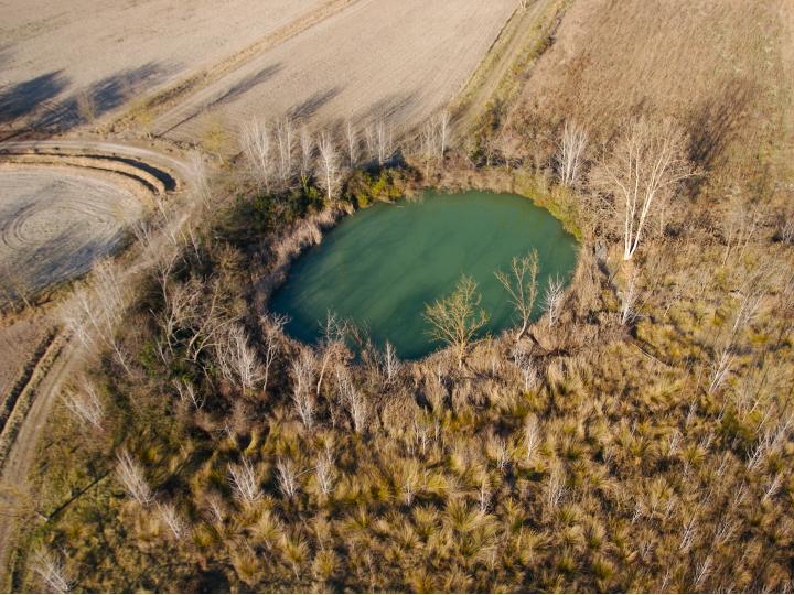
 Els punts de surgència d’aigua de l’aqüifer no només es concentren a l'Estany principal o als estanyols del voltant, sinó que hi ha diverses zones amb sorgències, i en períodes de fortes pluges apareixen nombrosos brolladors enmig de camps i boscos de la mateixa zona. Un exemple interessant d'això seria l'estany intermitent d'Espolla (N 42° 08.970 E 002° 45.962), situat 40m per sobre del nivell de l'Estany, i que només s'omple en època de fortes pluges, com a sobreeixidor natural de l'Estany de Banyoles, esdevenint un estany temporani.
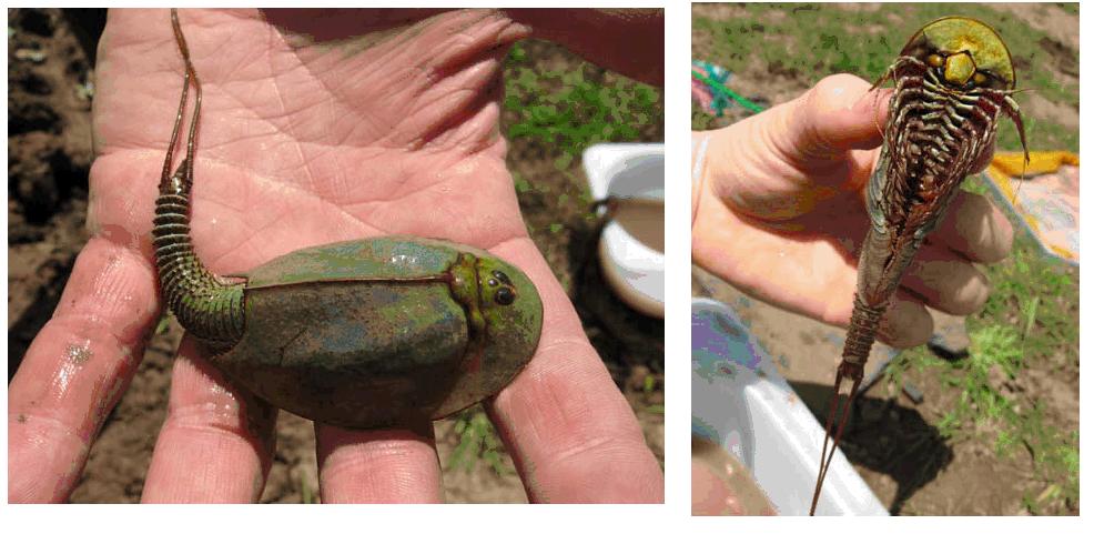
L’espai a més es molt interessant per la presència d’espècies animals adaptades a ambients inundables temporàniament. En aquest estany hi viuen uns animalons molt peculiars. Quan no hi ha aigua a l'estany moren deixant a terra els seus ous, que poden sobreviure molt temps, fins que torna a brollar l'aigua, llavors surten les cries i tornen a repoblar l'estany. Aquest mecanisme els ha permès sobreviure des de fa 220 milions d'anys. És per això que són considerats com uns fóssils vivients.
Pregunta nº3:
De quins animals estem parlant?
Pregunta nº4:
Quants banc hi ha a la vora del llac entre la pesquera Marimón (N42º07.003 E002º45.245) i la d'en Lero (oficina informació N42º07.072 E002º45.380) ?
Com registrar el cache?
Haureu d’enviar ( vía mail privat) les respostes a les 4 qüestions plantejades i opcionalment fer-se una foto de vosaltres mateixos amb el GPC en un punt del perímetre de l’Estany de Banyoles, veure exemple. Un cop hagui validar les respostes podreu registrar com a trobat .
Nota. Registres sense validesa en la resposta serán eliminats!!
ENGLISH VERSION:
Banyoles Lake is the largest inland water mass in Catalonia, with a great landscape value and displays of collective identity. At a scientific level may be considered a lake (but larger), although the official site and the locality name used by the habitants of the area is Estnay de Banyoles. It is the second largest natural lake in the Iberian Peninsula, after the de Sanabria (Zamora), which is glacial. The lake has a tectonic and karsts origin.
Origin & formation:
By definition a karsts system is characterized by processes of dissolution of limestone and gypsum by the action of water infiltrated into the groundwater, creating a certain relief. The characteristic of karsts areas is the movement of underground waters. Among the points of water infiltration and departure traffic set using the weaknesses of the layer of rocks and gives rise to a system of caves, where water wells and galleries, school freely or pressure generated by erosion and dissolution.
The functioning of the karst system of Banyoles lacustrine basin can be summarized in a few facts chains. Rainwater is infiltrated at Alta Garrotxa area feed an underground aquifer, which runs an underground river, southwards for materials that are permeable limestone. This groundwater emerges at the surface pressure system that causes the water rises through cracks and fissures of geological materials go up vertically to the surface as springs. With the passage of time the water that rises from the limestone subsoil to the surface of the plaster was dissolving the intermediate layers creating holes or cavities in surface sink to fill up water and cause formation of lakes.
The hydrogeological system operation is explained not only by the karstic origin but also for a tectonic origin. The flaw Albanyà which runs through the east side of lake basin marks a change of geological materials, so that the layer of limestone through which the aquifer has continued beyond Banyoles, and is a layer of marl, impervious material, resulting in increased pressure system forcing water out of a vertical through cracks and fissures to feed the lakes, ponds, fountains and boilers. The kettles, synonymous upwelling or spring, are points where the water emerges quite intermittently mixed with the air accumulated under the ground, creating the sensation of boiling water.
During the dissolution process of various materials originate cavities growing until the ground gives way and water comes out. The relief of the lake is drawn by six large buckets or subsidence, the background of some of which is occupied by a significant amount of mud in suspension. Thus was formed the lake and ponds around 250,000 years ago.
Question 1:
What name are these geological basins or large landslides formed by the collapse of the roof of the large cavities created by the water?
The lake has an elongated shape comparable to a number 8. At the bottom of Lake Banyoles there are 13 points of sorgent main water supply groundwater with a total of between 400 and 600 l / s (40,000 m3 of water daily). The set of inputs of surface water and groundwater, the volume of continually renewing the lake. The total time of renewal of this lake is over 200 days.
Importance of lake:
The lake area contains the most complete record of the Quaternary geological history of north-eastern Spain. Constitutes one of the few examples that allow global analysis of current processes related to sedimentation dynamics lacustrine deposits and apply it to old in the same area. It is also one of the best examples of active karst and its impact on land use.
The Pleistocene geological outcrops have provided a varied fauna of fossil mammals that are well preserved and exposed to the Regional Archaeological Museum of Banyoles. For all these reason that geozone (geological area of interest defined by the Generalitat de Catalunya) can be regarded as one of the best approaches to knowledge of the Quaternary in Catalonia.
Banyoles Stone:
Banyoles lake and ponds (little lakes) found in the surrounding area are rising from a lower level of the hydrogeological system. Six are the main streams that pour their waters in the lake, primarily for its western margin, and some other minor irrigation ditches that drain the head some of this water fountains, ponds or fields. The water that enters the streams and underground fill the pond and maintain more or less stable. Some artificial channels, called "irrigation", built by Benedictine monks from Banyoles in the ninth century used to drain water from the lake to the river Terri.
In addition to irrigation, there are two underground collectors used to flush the lake in anticipation of heavy rains and prevent the overflow. Formerly the lake empties, forming a natural overflow and flooded the plains of Banyoles to Cornella del Terri as evidenced by the accumulation of a very famous rock in the subsoil of the area. It is a sedimentary rock, formed mainly by calcite known as stone of Banyoles.
It is formed when calcium carbonate or lime carrying water precipitates forming on the surface layers and increasing the thickness of the rock. There are certain factors that accelerate the precipitation of lime as the temperature increases, the effect of water evaporation and photosynthesis that make cianòfits, algae and other plants that live on the rocks above. This is also causing widespread presence of fossil remains of plants and animals that are trapped between layer and layer.
Question No 2:
What is the rock known in the area as stone of Banyoles, and what is it used?
Espolla’s Lake:
The points of upwelling of water from the aquifer not only focus on the main lake or ponds around, but there are several areas where the water emerges, periods of heavy rains appear numerous springs surrounded by fields and forests the same area. An interesting example of this is Espolla intermittent lake (N 42° 08.970 E 002° 45.962), located 40m above the level of the lake, and only fills during heavy rains, as natural overflow of Lake Banyoles, becoming a temporary pond.
The place is much more interesting by the presence of animal species adapted to the temporal flooded. In this lake there lived a very stange animals. When no water in the pond died, leaving their eggs on land, which can survive a long time, until the water flowing again, then go back to repopulate the lake. This mechanism has enabled them to survive for 220 million years. That's why these fossils are considered alive.
Question No 3:.
Which aninals are there?
Question No 4:.
How many benchs are near the lake between Pesquera Marimón (N42 ° 07,003 E002 ° 45,245) and Pesquera d'en Lero (office information N42 ° 07,072 E002 ° 45,380)?
How to register the cache?
You must send (via private email) the anwers of four questions and optionally take a picture of yourself with the GPC at any point of the perimeter of Lake Banyoles, see example. Once we can validate the anwers, you can log as found it .
Note. Logs without valid answers will be deleted!