***This is an Earthcache!!!!***
***There is no container to find and the posted coordinates will
take you to a "put-in" on the Fox River, in Buffalo Park Forest
Preserve in Algonquin,
IL***
Welcome!
I grew up across the Fox River to the east of this spot, during
my formative years of 7 and 17 (from the late '70's, through the
late 80's). Throughout almost all of those years, we spent the
Spring, Summer, and Fall (and sometimes Winter), fishing, camping,
and playing in the "pocket woods" that used to exist there. The
area has been completely developed now, but try to imagine roughly
12-15 of the existing lots on the eastern bank, just to the north
of here, as a scattering of trees, thick underbrush, and meandering
trails. This was the playground of my youth!
The Fox River
The Fox River is a tributary of the Illinois River in the states
of Wisconsin and Illinois in the United States. The river rises
near Menomonee Falls, Wisconsin and flows past Brookfield,
Waukesha, Big Bend, Waterford, Rochester, Burlington, Wheatland,
Silver Lake and Wilmot, for a total of 70 miles (110 km) in
Wisconsin.
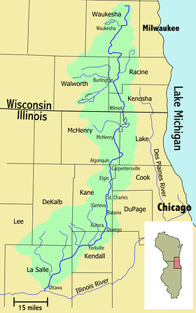
The river enters Illinois where it widens into a large area of
interconnected lakes known as the Chain O'Lakes. Fox Lake is the
largest city in this area. From the chain, the river flows
generally southward for 115 miles (185 km), until it joins the
Illinois River at Ottawa. Illinois towns that are on the Fox River
include (from north to south): Johnsburg, McHenry, Holiday Hills,
Island Lake, Cary, Fox River Grove, Algonquin, Carpentersville,
West Dundee, East Dundee, Elgin, South Elgin, St. Charles, Geneva,
Batavia, North Aurora, Aurora, Montgomery, Oswego, Yorkville,
Plano, Millington, Sheridan and Ottawa. Collectively, the area
surrounding the river is known as the Fox Valley. Around 1 million
people live in this area. Native American tribes that lived near
the Fox River included the Potawatomi, Sac, and Fox tribes. The
river has 15 dams, including McHenry Dam, which raises the river
slightly to maintain depth in the Chain O'Lakes in northern
Illinois. Early in the history of the State of Illinois, the river
provided water for the Illinois and Michigan Canal via a feeder
canal, allowing the canal to pass over the Fox River on an
aqueduct.
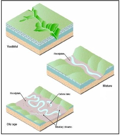
River Categories
Most sources regarding rivers divide river development into
three stages: Youthful rivers, Mature rivers and Old rivers.
Youthful rivers are usually narrow, with a V-shaped channel, fast
moving, and do not have a floodplain. Mature rivers are often still
fairly narrow, with a U-shaped channel, have a medium velocity, and
their path starts to meander due to erosion with narrow
floodplains. Old rivers are normally broad, slow-moving, and they
have wide floodplains and oxbow lakes.
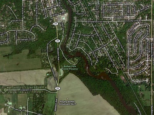
Meanders
A meander in general is a bend in a sinuous watercourse. A
meander is formed when the moving water in a river erodes the outer
banks and widens its valley. A stream of any volume may assume a
meandering course, alternatively eroding sediments from the outside
of a bend and depositing them on the inside. The result is a
snaking pattern as the stream meanders back and forth across its
down-valley axis. When a meander gets cut off from the main stream,
an oxbow lake is formed. Over time meanders migrate downstream,
sometimes in such a short time as to create civil engineering
problems for local municipalities attempting to maintain stable
roads and bridges. A meander in the Fox River in this location is
clearly visible in satellite imagery.
Floodplains
Flood plains are made by a meander eroding sideways as it
travels downstream. When a river breaks its banks and floods, it
leaves behind layers of rock and mud. These gradually build up to
create the floor of the flood plain. Floodplains generally contain
unconsolidated sediments, often extending below the bed of the
stream. These are accumulations of sand, gravel, loam, silt, and/or
clay, and are often important aquifers, the water drawn from them
being pre-filtered compared to the water in the stream. The
floodplain during its formation is marked by meandering or
anastomotic streams, ox-bow lakes and bayous, marshes or stagnant
pools, and is occasionally completely covered with water. When the
drainage system has ceased to act or is entirely diverted for any
reason, the floodplain may become a level area of great fertility,
similar in appearance to the floor of an old lake. The floodplain
differs, however, because it is not altogether flat. It has a
gentle slope down-stream, and often, for a distance, from the side
towards the center.
In order to log a find on this Earthcache, you
will need to complete all of the items
below:
- Take a
picture of you / your Geocaching Team and/or just your GPSr at the
posted coordinates, with the river in the background, and post it
with your "Found It" log entry.
- Based on
your observations, would you classify this as a Youthful, Mature,
or an Old river?
- Based on
your observations, how many inches would the river have to rise
before the houses along the riverfront on the East bank begin to
see water in their yards?
- How about
the houses on the West bank of the river?
- Send me an
e-mail through my geocaching profile page with your answers to the
questions above. Also tell me if you think the floodplain is to the
East or the West of the Fox River in this area, based on your
on-site observations of the area.
- HAVE
FUN!!!!
=====================================
== CONGRATS TO streamwood_cachers ON THE FTF!!!! ==
=====================================