Lynde Shores - Cranberry Marsh EarthCache
Lynde Shores - Cranberry Marsh
-
Difficulty:
-

-
Terrain:
-

Size:  (not chosen)
Please note Use of geocaching.com services is subject to the terms and conditions
in our disclaimer.
Cranberry Marsh is designated as a provincially significant
wetland. It's formation was influenced by the prehistoric post
glacial lake, Lake Iroquois.
Glacial Lake Iroquois was a post glacial lake from which Lake
Ontario and its surrounding watersheds formed. Glacial Lake
Iroquois existed at the end of the last ice age approximately
13,000 years ago and was formed as a result of the St. Lawrence
River being blocked by a large ice sheet near the present day
Thousand Islands. It was also approximately 30 m higher than
current Lake Ontario and its shoreline was approximately 13 km from
the current shoreline of Lake Ontario at Cranberry Marsh. The
retreat of this glacial lake shaped the surrounding landscape
including the underlying bedrock leading to the formation of the
watershed in this area of which Cranberry Marsh is a part.
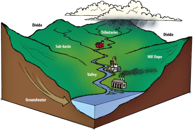
Watersheds are landscape-level systems through which water drains
and flows.
Freswater Marsh Types:
Three major types of freswater marshes have been defined for
Canada, and their classification reflects their phyiscal nature
including its depth and water supply.
- Terminal basin marshes have a well-defined basin filled with
water and usually contains robust emergent vegetation. Water is
supplied from rainfall, snowmelt or small streams, and sometimes
from groundwater springs.
- Fluvial marshes are generally associated with the floodplain of
a river and is subject to seasonal flooding and deposition of silt.
Portions of the marsh may dry out at certain times. The formation
of oxbow lakes is a common occurrence during the frequent changes
in the river course at these locations.
- Shore marshes are formed where gravel, sand and soil is
deposited along the shores of large lakes by wave, wind or ice
action. A marginal basin is then created, which traps water moving
from the surrounding watershed.
Freshwater Marsh Formation:
Freswater marshes are formed mainly by the infilling of ponds and
shallow lakes. The physical aspects of freshwater marshes
include:
- Bedrock: minimal outcropping; soft sedimentary rocks in the
watershed contribute to soil development.
- Soils: alluvium, fine material rich in organic material and
nutrients.
- Relief: low, generally flat, gently sloping to water.
- Drainage: poor, wet site with standing water in
depressions.
Cranberry Marsh
Cranberry Marsh is a very diverse and highly complex ecosystem and
has the ability to filter out a variety of harmful impurities, such
as phosphorus and nitrogen. These nutrients, which can be generated
from industrial development and agricultural activities can enter
the water system and seriously pollute the water that life depends
upon. Studies have shown that up to 92% of phosphorus and 95% of
nitrogen entering a watershed can be trapped, broken down or
absorbed by wetlands. Thanks to the variety of life including
microbes and filter feeding invertebrates, wetlands, such as
Cranberry Marsh, can also filter out up to 90% of harmful bacteria
from the water. Up to 70% of runoff sediment can also be trapped by
wetlands – this not only helps to purify the water, but
lessens the impact of erosion.
Wetland Size
When it comes to marshes, bigger is better. One 10 hectare marsh,
or a complex of ten smaller marshes that are close to one another
provide much better habitat for wildlife than ten 1 hectare marshes
that are widely separated from one another. In conjunction with
size, varying water levels throughout the marsh are important for
sustaining a vibrant community of plant and animal life. If the
marsh is too shallow throughout its area, it can be choked off by
dense mats of vegetation – therefore areas of deep water (up
to 2 meters in depth) are essential. Marshes in the Great Lakes
basin that are greater than 25 hectares (250000 m2) are
shortest in supply and require the highest conservation
efforts.
Logging Requirements:
To log this Earthcache, perform the following tasks and
determine the answers to the questions below. Email me your
answers, DO NOT include them with your Found It log.
- Go to the posted co-ordinates where you will find the Cranberry
Marsh viewing platform and an information panel. What are the two
prominent types of vegetation that grow at Cranberry Marsh? Record
your elevation at this location.
- Proceed to the Raptor Watching parking co-ordinates on the west
side of Cranberry Marsh. Follow the trail east and when it forks,
go left to the Raptor Watching platform. Once there, create a
waypoint. What is the distance between the Raptor Watching and
Cranberry Marsh platforms?
- Given that the width of Cranberry Marsh is approximately equal
to its length, what is the approximate area, in hectares, of
Cranberry Marsh?
- Return to the fork in this trail and take the right branch to
its end. Record your elevation here. What is the difference between
this elevation and that at the Cranberry Marsh viewing platform. Is
the slope between these two points high or gentle?
- Now that you have had an opportunity to see both sides of this
marsh, to which of the three types of marshes does Cranberry Marsh
belong? Give at least two reasons for your answer. (Hint: Look at a
satellite image of the area. Is Cranberry Marsh fed by small
streams, a large river with oxbow lakes or can high levels of Lake
Ontario contribute to the creation of a marginal basin?)
Optional: Post an image of any area of the marsh that you
have visited. Feel free to include yourself and any other members
of your group, but not your GPS, in the image.


Additional Hints
(No hints available.)