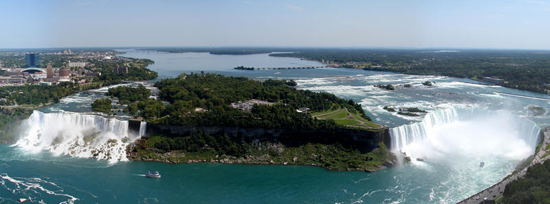
Goat island is part of the Niagara River Corridor and has been a
part of this landscape for only about 500 years. The Niagara River
flowed through here with a much greater enthusiasm for 12,000 years
before that, which makes the falls quite young in terms of
geological standards. It seems that a piece of sediment (must have
been a tremendous piece) from a now vanished Lake Tonawanda,
obstructed the river to form this island and in turn, split the
falls into two separate areas.
The island got its name from Fred Stedman (an early pioneer and
miller). He kept a herd of goats on the island. Upon returning to
the island after the terrible winter of 1780, Stedman found all but
one of the goats had died; thus giving the island its name.
What has the formation of this island done to affect the local
geology? When this island was formed it created an interruption in
the flow rate of the water. A sort of water 'speed bump' that
helped reduce the rate of erosion caused by the large volume of
water.
The erosion of this island continues; if left to itself it would
eventually be consumed by the receding falls on the west and the
unceasing flow of water from the east. Efforts have been made to
extend the island by adding material form the construction of
Robert Moses Parkway (circa 1959-60). There was an addition of 8.5
acres (34,000m^2) to the eastern side of the island.
This island is a combination of sediment and a mix of the shale
and dolomite that is the foundation for the local bedrock. But as a
result it provides a magnificent platform to view the falls and a
beautiful example of an amazing 'geolocality' that documents the
areas history!
In order to log this Earthcache you will need to answer a couple
of questions, the first can be retrieved from signage very close to
the listed waypoint.
1. What 3 geological features contribute to the formation of
this region?
2. Use your GPSr to measure the approximate area of the
island and its perimeter. Do your best, but be sure to respect all
barriers and off-limit areas!
3. Make an estimation as to how long it would take the
Niagara River to consume this island by means of erosion?
Please email me your answers and don't post them or include pics
of the signage. Any logs with the answers included will be asked to
be altered or removed. Feel free to post any pics you may have of
yourself, your team, your GPSr, or any of the beautiful sights
close by! Enjoy your time here at Goat Island!