50 Mile Mountain & the Grand Staircase EarthCache
50 Mile Mountain & the Grand Staircase
-
Difficulty:
-

-
Terrain:
-
Size:  (not chosen)
Please note Use of geocaching.com services is subject to the terms and conditions
in our disclaimer.
Fiftymile Mountain
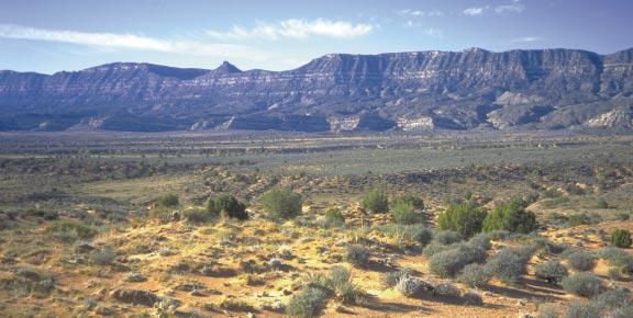
A major plateau known in early literature as Wild Horse Mesa is
surrounded by 1,000 foot cliffs and extremely rough canyons. It is
part of a 146,000 acre Bureau of Land Management (BLM) wilderness
study area within Grand Staircase-Escalante National Monument.
Pinion, juniper, and open grass and sagebrush cover the top of the
plateau, with aspen in isolated patches, usually at canyon heads.
Archaeology in the area is significant because of the density of
late Ancestral Puebloan occupation sites.
Forming a nearly continuous escarpment for more than 50 miles along
the eastern edge of the Kaiparowits Plateau (Kaiparowits Basin
section), the Straight Cliffs present a series of stacked marine
sandstone layers within the Straight Cliffs Formation. These
sandstone layers were probably barrier islands during the Late
Cretaceous nearly 90 million years ago. Behind these barrier
islands swamps formed that favored the creation of the thick coal
beds seen in the Kaiparowits Plateau area. Today, the Straight
Cliffs closely follow an ancient shoreline of the Late Cretaceous
Western Interior Seaway. Another name for the Straight Cliffs is
Fiftymile Mountain. Between Escalante and the Colorado River, a
distance of 50 miles, only two canyons break the otherwise straight
line of cliffs.
Getting There
From Scenic Byway 12, just east of the town of Escalante is the
Hole In The Rock Scenic Backway Rd. Turn south onto the Hole In The
Rock road and travel for about 13-15 miles to the posted
coords.
Generally the Hole In The Rock Road is passable by most passenger
vehicles, however the occasional rain storm can make it difficult
without 4 wheel drive. The dirt road has a lot of washboard areas
that make for a somewhat bumpy ride, but you shouldn't run into any
problems with the Hole In The Rock road unless you are going
further than the posted coords. I have posted the coords here for
this reason, and for the fact that at this location, you are almost
directly across from the beginning of Fiftymile Mountain. You can
check road conditions with the Monument Visitor Center in
Escalante.
Escalante Interagency Visitor Center
755 W. Main
Escalante, UT, 84726
435-826-5499
For more information about the Grand Staircase Escalante National
Monument, check out their website at www.ut.blm.gov/monument/
Logging Requirements
- Email me with the answers to these questions (do your best, I'm
not a harsh grader):
1.) At the posted coordinates, you will be at a turnoff and there
will be a sign at the corner with information about a nearby
geological area. Email me the information from the sign. (It's
brief, don't worry. HINT: don't forget to send me the number as
well.)
2.) How many different layers do you see that make up Fiftymile
Mountain, and what are they made of?
Optional, but strongly recommended logging requirement:
3.) At the posted coords you can look south-southwest and see the
full length of Fiftymile Mountain. Post a picture of you with the
mountain behind you.
General Information:
Grand Staircase-Escalante National Monument spans almost 1.9
million acres of south-central Utah, a region that was the last
place in the continental US to be mapped. This is an area of high
plateaus, deep canyons and multi-hued rock formations and cliffs
that can extend for up to 100 miles. This is a world-class geologic
sampler displaying 200 million years of Earth changes in a very
large remote area filled with very difficult terrain.
Annual precipitation in the region varies from about six inches at
the lowest altitudes near Lake Powell (4,000 ft), to about 25
inches at the highest altitudes near Canaan Peak (9,280 ft). The
variations in altitude and precipitation produce three climatic
zones: upland, semidesert, and desert. At the highest altitudes,
precipitation falls primarily during the winter. The majority of
precipitation in the semi-desert and desert areas occurs during the
summer months. You will want to be cautious when exploring this
area, mainly the slot canyons further down the road from this
Earthcache. They are amazing, but when rain falls, even miles away,
it washes down this sloped staircase quickly and can produce flash
floods through the canyons.
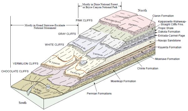
The Grand Staircase (see image above) is the name given to a
series of spectacular cliffs rising step-by-step northward from
the Grand Canyon area. Each line of cliffs, from the Vermillion
Cliffs to the White Cliffs to the Gray Cliffs to the Pink Cliffs,
is composed of different layers of depositions made over the last
200 years. The Vermillion Cliffs are deep red Moenkopi sandstone on
top of Chinle badlands, and the formations contain fossils of fish
and small dinosaurs from the late Triassic Period. The White Cliffs
where you are standing, are Navajo sandstone (solidified Jurassic
sand dunes). The Gray Cliffs, part of which is Fiftymile Mountain
that you see here, are ocean-bottom shale filled with the
fossilized remains of marine life and beds of marsh and swamp
plants compressed into coal. The Pink Cliffs at the top of the
Staircase (seen in Bryce Canyon) are composed of limey sandstone
deposited in the bottom of an ancient large freshwater lake.
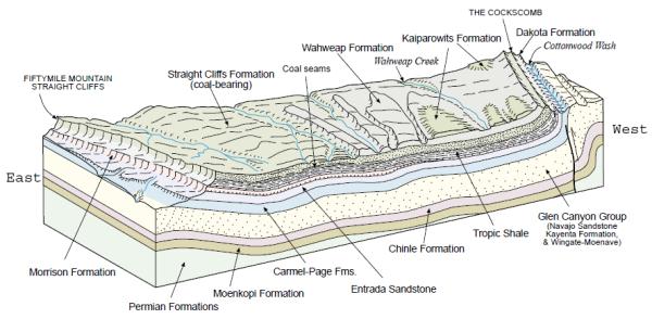
| The Kaiparowits Plateau (see image above) is an
800,000-acre-plus area of incredibly rich fossil deposits from the
late Cretaceous Period. I have been to an area down this Hole In
The Rock road where you can see dinosaur footprints preserved in
the rock! (see picture on right) The plateau is a very dry and
highly eroded area of sheer cliffs, wide canyons and poisonous
soils. Many of the red hills of oxidized rock that you'll find here
were created in the aftermath of huge underground coal fires. The
eastern edge of the Kaiparowits Plateau is marked by the Straight
Cliffs of Fiftymile Mountain that drop to the Fifty-Mile Bench
(where you are standing) via a sheer, 2,200' escarpment. The
Kaiparowits Plateau itself is a highly eroded but shallow slope
dropping slowly to the south and west. |
 |
During the later part of the Cretaceous geologic period, the area
that is now the Kaiparowits Plateau was located near the western
shore of the Western Interior Seaway. The interior of the plateau
was an area of peat swamps, while what is now the Straight Cliffs
were at the shoreline. Further to the west was an area known as the
Sevier Highlands. Erosion from the Highlands deposited
approximately 1500 feet (500 m) of what is now known as the
Straight Cliffs Formation, a layer of sandstone that makes up the
base of the plateau. Remnants of the peat are now seen as beds of
coal within this layer. Later deposits during the Cretaceous period
formed higher sandstone layers, known as the Wahweap and
Kaiparowits Formations. Further deposition during later epochs
formed layers that are now seen at the surface of the plateau,
including the limestone layers of the Wasatch Formation.
Hole-In-The-Rock and the
Pioneers:

In the fall of 1879, a group of Mormon volunteers collected their
wagons, families, livestock and supplies at a spring in Fortymile
Gulch, just north of the Kaiparowits Plateau cliffs and just south
of the canyons that make up the Escalante River Basin. A small
group went ahead of the rest to scout out and prepare a crossing of
Glen Canyon and the Colorado River. While parts of the area are
relatively benign for travel, the whole region is criss-crossed
with deep canyons, some of them bordered by 1,200 foot sandstone
cliffs. As they approached Glen Canyon, they spied Cottonwood
Canyon on the eastern side of the Colorado and thought it would be
a good place to regain the heights after crossing the river. Then
they found a narrow, steep crevice in the western wall of Glen
Canyon that they named "Hole in the Rock." (If you follow this Hole
In The Rock road another 50 miles, the length of the mountain,
you'll come to this awesome historic place. You'll also see other
historic locations along the way where the pioneers stopped, such
as Dance Hall Rock. While the Hole-in-the-Rock trail was being
forged in 1879, the Mormon pioneers camped at Fortymile Spring and
held meetings and dances in the shelter of the stage-like erosional
feature of the Entrada Sandstone known as Dance Hall Rock. The site
was designated a National Historical Site by the U.S. Department of
the Interior in 1970. Do not attempt to drive the length of this
road without first checking with the Escalante Visitor Center for
road conditions, and you'll definitely need 4-wheel drive!)
They spent a couple months working over the Hole in the Rock
pathway, using blasting powder to widen parts of the upper section
and chiseling anchor points (to attach ropes to) directly into the
rock. The lower section crossed a gully full of large boulders so
they built a wooden trackway around it. Finally, on January 26,
1880, 250 people, 83 full-sized wagons and more than 1,000 head of
livestock began the journey down through the crevice to reach and
cross the river. The wagons were heavily roped and attached to
teams of men and oxen to be lowered through the almost 45° slopes
in the upper part of the canyon. It was an arduous mode of travel
but 1/3 of the expedition reached the river on the first day, the
rest being down to the river by January 28. Charles Hall had built
a wooden ferry at the river and everyone was soon across with no
damage. Then they had the much harder task of ascending Cottonwood
Canyon and traveling into southeastern Utah. The bottom of the
canyon can be reached from the east only by boat on Lake Powell
(Buoy 66).
The maze of canyons east of the Colorado forced the expedition to
go north until they arrived on top of Cedar Mesa (near present-day
Natural Bridges National Monument). From there, they made their way
down into Comb Wash and headed south for the environs of the San
Juan River. Finally, they decided they'd had enough and settled
into what is now known as Bluff.
The journey was originally planned to take six weeks, they ended up
taking six months. Nobody died along the way but two children were
born. The route continued to be used for supplies for maybe one
year, then Charles Hall moved his ferry crossing north on the
Colorado to a place that made for a much easier crossing of the
river.
Additional Hints
(No hints available.)