Grumm-Grzhimaylo Glacier
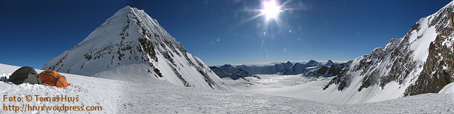
The upper part of the Grumm-Grzhimaylo Glacier.
On the left side you can see Pik Grina, on the rigt side the slope
of Pik Revolutsii.
Photo taken from 6000 m
Grumm-Grzhimaylo is the second-largest gracier of Pamir. His
length is 25 kilometers.
The glacier got his name after a Russian entomologist and
discoverer Grigory Yefimovich Grumm-Grzhimaylo (1860-1936, see
link 1
or
link 2).
The beginnig of Grumm-Grzhimaylo glacier is at approx. 5600
meters between Pik Grina (6502m -
see photo) and the highest mountain in the neighbourhood -
Pik revolutsii (6974m -
see photo).
The end of the glacier is at 3500 meters (see
photo) near the valley of the river Tanymas. (see
photo)
To get the cache you have to start from the road from Karakoul
to Goudara - see coordinates of the Trailhead (N 38° 39.919 E 072°
47.069). To Karakoul you can come from the north form Kyrgyzstan
(Sary-Tash) or from the south via Khorog - Murgab. To Goudara it is
possible to come throught the Bartang valley from Rushon.
You have to pass the Tanymas valley and then go up on the
moraines at the right side of the glacier. The hike is not
extremely difficult, but it is long (appox. 35 km) and you have to
cross few rivers including Tanymas.
It is not necessary to move on the glacier! It is much
more easy to come to this place beside the glacier, as shown
on the picture.
You can find more informations (coordinates of other usefull
waypoints etc.) about the way to the cache on the web of our expedition.
The aim of the cache is show you beatifull mountains and this
large glacier. It is not difficult to find the box, but you are in
the mountains and so it is not quite easy to come to the place of
the cache. Because of this facts is the terrain-rating set to
5 and the difficulty set to 1.5.
Please use fotohints!
Fotohints
 |
 |
|
Cache
placement
|
View from the
cache
|
 |
 |
 |
|
Fotohint
A
|
Fotohint
B
|
Fotohint
C
|
See also a
videohint!
Gallery
See a small photogallery of the glacier