Erosion on top of Mt. Mansfield EarthCache
Erosion on top of Mt. Mansfield
-
Difficulty:
-

-
Terrain:
-

Size:  (not chosen)
Please note Use of geocaching.com services is subject to the terms and conditions
in our disclaimer.
 >
>
Inroduction
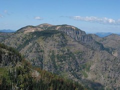
Erosion is the process that changes the shape of an object
(sediment, soil or rock) by water, ice or wind. A great example of
erosion can be found on the top of the mountain. Because there is
no cover on top of the mountain by trees. So the wind and the rain
can easily affect the rock. Also the climate is cold enough for ice
to form, a big factor in this matter.
How was the mountain
formed, and what type of mountain is it?
Mount Mansfield was formed like most mountains, it starts when two
plates collide with each other. The land will uplifte. Depending on
the geological process (climit, wind, water, ice/snow),will depend
what kind of mountain it is. There are five major types of
mountains;
**Fold Mountains:** They are the most common type of mountains.
They are formed due to collision of two plates. Example:
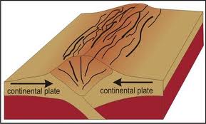
**Fault-Block Mountains:** As the name describes them, fault
mountains or fault-block mountains are formed when blocks of rock
slide along faults in the Earth's crust. Example:
**Volcanic Mountains:** They are formed when there is a
volcanic eruptions. When the
volcano erupts magma piles up on the surface of the Earth, and
creates the mountain. The magma can also create islands.
Exanple:

**Dome Mountains:** Dome mountains are made when the magma goes
under the sedimentary layer of the Earth's crust. They are called
dome mountains because they look like domes. Exanple:
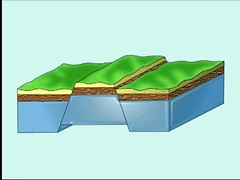
**Plateau Mountains:** Plateau mountains are mountains that are
formed by erosion. Example:
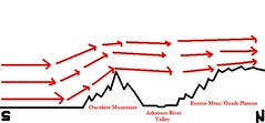
About 400 million years ago,the Green Mountains (the chain of
mountain across Vermont) was created to to volcanic activaty.
Fun Facts
#1 Mount Mansfield is one of the most popular mountains to hike in
Vermont.
#2 Almost everyone takes the Sunset Ridge Trail.
#3 "The Laura Cowles Trail is pure evil."
-Ed Cyzewski
What else is the moutain used
for?
The mountain is used for many recreational and commercial use. On
"The Nose" is there is are transmitter towers for regional radio
and TV stations. Also, the east side of the mountain is used by the
Stowe Mountain Resort for winter skiing. You can also hike some
trail at Stowe Mountain Resort. == ==
How high is Mount
Masfield?
Mount Masfield is the highest mountain in Vermont. It is 4,395 feet
(1,340 m) high.
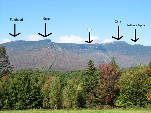
Why is the mountain called
Mount Masfield?
The mountain is called Mount Masfield because if you look at it
from east or west the mountain look like a humain head. But unlike
most human faces, the chin is the highest point. Hear is what it
looks like:
How to get
there?
To get to this earthcache can go up any trail. It will cost $2.50
per person. The parking coordonets are: N44 31.749 W072
50.583
If you want you can also take the rode that goes all the way up the
mountain. From this rode the earthcache is about a mile away. But
it will cost you $24.00 per car The name of the rode is "Toll
Rode". The parking coordonets are: N44 31.679 W072 48.912
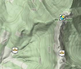
Here is a map that shows you the parking area, it is easy to see
that the parking area that is on the mountain is the one you have
to pay $24.00 (per car) to use.
The trails information is in the waypoints's descriptions
bellow.
What is your
job?
To log this Earthcache: You must visit the area and answer an earth
science question. There is no container or logbook for you to sign.
You will also have to post a picture of you or your GPS in front of
the earthcache site you will also need to answer the following
Question:
What type of mountain in Mount Masfield?
A)**Fold Mountains**
B)**Fault-Block Mountains**
C)**Volcanic Mountains**
D)**Dome Mountains**
E)**Plateau Mountains**
Check the hint section if you need help.
Email the anwser to : tubeex1995.info@yahoo.ca
Please start you email with the name of the earthcache or the GC
code.
Before posting your find log, wait for me to send you an email back
saying that you have the right answers. If you want you can post a
"note" and change it to a find log when you get an email back from
me saying you have the right information.
Additional Hints
(Decrypt)
Lbh jvyy qvfpbire gur nafjre jura lbh trg ba gur gbc bs gur zbhagnva, lbh jvyy ernyvmr gung gur zbhgnva vf ernyyl s__gre guna bgure zbhagnvarf. Guvf vf jul Zg. Znfsvryq vf n _____________ Zbhagnva.