 German:
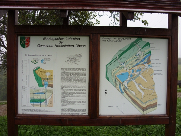
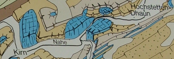
Das Kirner Land, zwischen Soonwald und Nahe-Bergland gelegen, bietet mit seinen vielfältigen Gesteinen die Möglichkeit einen Abschnitt der Erdgeschichte kennenzulernen, der vor mehr als 400 Mio. Jahren begann.
Durch die Wechselwirkung von inneren und äußeren Erdkräften veränderten sich während dieser langen Zeitspanne das Klima und die Verteilung von Land und Meer. Gebierge enstanden und wurden wieder abgetragen. Lebewesen starben aus, neue, den veränderten Umweltbedingungen angepaßte Formen, entwikelten sich.
Seit etwa 150 Jahren werden diese Vorgänge im "Hunsrück" und Nahe-Bergland erforscht. Die Untersuchungen des anorganischen und organischen Stoffbestandes der Gesteine ergaben Hinweise auf die chemischen und physikalischen Bildungsbedingungen sowie auf die Lebewesen und deren Lebensraum. Die im Gestein vorhandenen Flächensysteme wie Schicht-, Schieferungs- und Störungsflächen ermöglichten eine Rekonstruktion der Lagerungsverhältnisse und der damit verbundenen Vorgänge. Die Ergebnisse dieser Untersuchungen werden zusammengefasst und fließen in die Darstellung der Geologischen Entwicklungsgeschichte dieser Region ein. Eine Zeitliche Zuordnung der Gesteinsserien und der geologischen Vorgänge ermöglicht die Tafel an den oben angegebenen Koordinaten mit der Schichtenfolge des Kirner Landes. Durch die Faltungsvorgänge an der Wende Unterkarbon/Oberkarbon vor etwas 325 Mio. Jahren läßt sich die Schichtenfolge in zwei große Einheiten gliedern:
1. Der Südhunsrück mit steilstehenden, überwiegend marinen Gesteinsserien aus der Zeit des Vordevons, Devons und Unterkarbons, also vor der Faltung entstanden.
2. Das Nahe-Bergland mit überwiegend flachliegenden, kontinentalen Gesteinsserien des Oberkabons und Perms, nach der Faltung abgelagert.
Hier kann auf einem Rundwanderweg die erdgeschichtliche Entwiklung dieser Region mit einer Auswahl typischer Gesteine im Zusammenhang mit den Vorgängen bei der Orogenese (Gebirgsbildung) kennengelernt werden.
 » Der Cache «
Vervollständige meine angefangenen Sätze und beantworte meine Fragen mit den
Informationen auf der Infotafel beim Metamorphit und sende sie mir per
E-Mail,
gerne könnt ihr loggen, ich werde mich nur melden falls die Antworten nicht in Ordnung sind.
Über Fotos von eurem Besuch würde ich mich sehr freuen.
Danke :-)
1.
Die Gesteine die bei diesem _________________ entstehen, heißen ____________.
2.
Um die metamorphosen Gesteine zu deuten, muß der ______________ und
der _________ sowie das Gefüge und die Lagerungsverhältnisse untersucht werden.
3.
Herkunft: Quarzitwerk _________, Werk _____

Viel Erfolg wünscht Mala :-)
~~~~~~~~~~~~~~~~~~~~~~~~~~~~~~~~~~~~~~~~~~~~~~~~~~~~~~~~~~~~~~~~~~~~~~
~~~~~~~~~~~~~~~~~~~~~~~~~~~~~~~~~~~~~~~~~~~~~~~~~~~~~~~~~~~~~~~~~~~~~~
~~~~~~~~~~~~~~~~~~~~~~~~~~~~~~~~~~~~~~~~~~~~~~~~~~~~~~~~~~~~~~~~~~~~~~
 English:
The area of Kirn between the "Soonwald" and the mountains close to the River Nahe offers with its varied rocks the possibility to get to know a segment of the earthhistory which startet more than 400 million years ago.
By the interaction of internal and external earth-forces during this long time the climate and the distribution of land and sea changed. Mountains have been addrued and removed, creatures have been declined, new creatures have been addrued and conformed themself to the new environmental conditions.
For about 150 years these processes are investigated in the "Hunsrück" and the mountains along the River Nahe. The investigations of the inorganic and organic material continuance of the rocks gave advice to the chemical and physical educational terms as well as to the creatures and their living space. The surface systems available in the rocks allowed a reconstruction of the storage relations and the processes linked with it. The results of these investigations are summarised and flow into the representation of the geologic history of this area. A temporally allocation of these rockseries and the geologic processes are allowed by the infoboard at the coordinates given on top with the layer-sequence of the area around Kirn. By the fold processes in the turn of the lower carboniferous to the upper carbonifeours 325 million years ago the layer-effect can be arranged of two big unities:
1. The south of the "Hunsrück" with steeply and most marine-geological stone-series of the pre-devonion-time, the devonian-time and the lower carboniferous.
2. The Mountains along the River Nahe (Nahe-Bergland) with predominantly level-recumbent, continental rock-series of the upper carboniferous and the "Perm", deposited after the folds.
Here you can see on a walktrough the geological evolution of this area with a choice of typical rocks in a connection with the processes of the orogeny.
» The Cache «
Please complete my uncompleted sentences, answer the questions using the information
from the infoboard at the "Metamorphit" and send me the answers by
e-mail.
If your answers are correct, you will get my permission soon.
I would be very happy, about Photos of your visit.
Thank you :-)
1.
The rocks, which addrued at this _________________ are called ____________.
2.
For interpreting the metamorphose-rocks you have to examined the ______________ and
the _________ well as the structure and the storage relations.
3.
Origin: Factory of Quarzit _________, Factory _____
Have fun - Mala :-)