La signature de ce cataclysme connu sous le nom de limite Crétacé-Tertiaire ou LIMITE K-T est visible en de rares endroits de la planète. La Côte Basque possède le privilège de comporter deux témoins de cette limite.
C’est vers l’un d’eux que va vous conduire cette Earthcache.

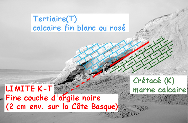
Limite K-T sur la Côte Basque
En quoi consiste cette limite K-T ?
Elle se matérialise sous forme d’une fine couche sédimentaire d’argile noire (2 cm env. sur la Côte Basque) contenant une teneur en iridium anormalement élevée. Or, si l’iridium est rare sur terre il est abondant dans les météorites. De là à penser que la disparition brutale des dinosaures serait dû à l’impact d’une météorite, il n’y a qu’un pas.
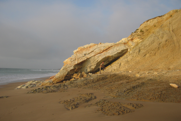
Pour atteindre cette Earthcache, vous partirez de la plage d’Erretegia située à Bidart (Parking PK). Cheminer 500 m env. vers le Nord-Est, en direction de Biarritz. L’approche des falaises est signalée comme étant dangereuse suite à de possibles mais rares chutes de pierres. Soyez par conséquent vigilents.
Selon le coefficient de marée le lieu peut être inaccessible par la plage à marée haute. On l’atteindra alors en empruntant un sentier bien marqué qui longe le haut des falaises (final un peu escarpé !).
Pensez à consulter l’horaire et le coefficient des marées sur le site du SHOM (service hydrographique et océanographique de la marine)
http://www.shom.fr/
Pour valider cette cache vous devrez vous rendre au point proche S1. Vous y observerez une série de trous (mini carottages) pratiqués dans la roche (voir photo ci-jointe).
Dans quel étage géologique ont été prélevés ces échantillons : Maestrichtien (fin du Crétacé) ou Danien (début du Tertiaire) ?
Envoyez-moi simplement votre réponse et loguez-vous en Found-it sans plus attendre.
Nous vous contacterons en cas de problème. N'hésitez pas à poster une photo qui témoigne de votre passage sur les lieux (facultatif)
Bon geocaching !!!
ENGLISH
The sudden disappearance of dinosaurs 65 millions years ago has marked the end of the Cretaceous period (symbol K) and the beginning of the Tertiary one (symbol T).
This large-scale biological crisis in History find an explanation in the fall of a meteorite that occurred at that time and had been the cause of a huge cataclysm.
The mark of this cataclysm known as the Cretaceous-Tertiary or K-T BOUNBARY is visible in only few places on earth. The Côte-Basque has the privilege of having two of them.
This Earthcache will lead you around one of this historical witness !
What is the K-T boundary?
He materializes in the form of a thin sedimentary layer of black clay (2 cm approx. on the Côte Basque) containing an abnormally high iridium concentration. However, if the iridium is rare on Earth is abundant in meteorites. Hence suggesting that the sudden disappearance of the dinosaurs was due to the impact of a meteorite, there's only one step.
To achieve this Earthcache you leave the beach Erretegia located in Bidart (Parking PK). Walk 500 m approx. north-east, towards Biarritz. The approach of the cliffs is identified as dangerous due to possible falling rocks but rare. Therefore be vigilant.
According to the tide, the location may be inaccessible by the beach at spring tide. You should then reach the location by a well marked trail along the top of cliffs.
Remember to have a look to the schedule and the coefficient of tide on the SHOM website (hydrographic and oceanographic service of the navy - http://www.shom.fr/)
To validate this cache you have to :
1) Log your visit with a picture showing the location with your GPS. This photo, once in the gallery of the cache, will show us the evolution of this place facing severely the erosion of the sea and rain.
2) Get to the point near S1. You will observe a serie of holes (small cores) formed in the rock (see photo attached).
Tell me by email which geological floor samples were collected from these: Maastrichtian or Danian?
Good geocaching !!!