Most of the
activity in Kentucky has occurred in the western portion of the
State, near the New Madrid seismic zone, named after the Missouri
town that was the largest settlement on the Mississippi River
between St. Louis, Missouri and Natchez, Mississippi. The New
Madrid earthquakes of 1811-1812 were the largest earthquakes ever
recorded in the eastern United States. The epicenters of the quakes
were only a few miles south of the southwestern tip of
Kentucky.
THE
REQUIREMENTS...
A. To meet the educational objective of
this earthcache, send the answers to my email by
selecting the link above. Please do not include the answer in
your posted log.
1) On your GPS or map, calculate the
distance in kilometers from this location to New Madrid, Missouri
(N36 35.187' W089 31.637') . If
the primary wave travels at a speed of at 8 kilometers/sec, how
long would it take for you to feel the first tremor after an 8.0
earthquake occurs in New Madrid?
2)
If the S-waves travel slower at a rate of 5
km/s, how long will this location experience any damage after an
8.0 earthquake occurs in New Madrid?
3)
Geologically look at this site and its
surroundings. Describe any evidence of the 1811-1812 or any recent
earthquake activity, such as erosion by the reverse flow of the
Mississippi River, sandblows, specific types of faulting, folding,
uplift, subsidence, and/or rifting .
4)
Using the USGS EHP website:
a)
give the time and date of your visit;
b) determine the date, time, and intensity
of the closest and
most recent
earthquake in the NMSZ.
B.
(Optional but Greatly Appreciated) Take a photo of you
(and your group) at the Historical
Marker. Upload the picture(s) to your posted log.
THE
QUAKES...
At least three
separate earthquakes were recorded. The first principal
earthquake, magnitude 8.6, occurred after midnight in northeast
Arkansas on December 16, 1811 causing only slight damage to
man-made structures, mainly because of the sparse population.
A second shock, magnitude 8.4 occurred in southeast Missouri on
January 23, 1812. On February 7, 1812, a third principal
quake, magnitude 8.8 occurred along the Reelfoot fault in Tennessee
and Missouri.
Several major
after-shocks occurred between these main shocks. The first and
largest after-shock, magnitude 8.0, occurred in the morning
on December 16, 1811 at about 7:15 a.m.. During the day and the
next, at least three after-shocks, magnitude 6.0-6.5 also
occurred. As many as 200 moderate to large after-shocks may
have occurred between December 16, 1811 and March 15, 1812, ranging
in magnitude from 3.0 to greater than 6.0.
The earthquakes were
perceptible over an area of 5,000,000 square kilometers with
reports as far way as New Hampshire. Widespread damage occurred
over an area of 600,000 square kilometers. Minor structural
damage was noted as far north as St. Louis, and as far east as
Cincinnati. Sidewalks buckled and cracked in Washington, D.C. and
bells rung as far way as Boston.
The following quotes are taken
from newspaper articles published after the December 16, 1811,
quake.
Frankfort . "About two o'clock on Sunday night
was felt in this place a violent shock of an earthquake. It
continued for several minutes and produced a considerable vibration
of houses. Some bricks are said to have fell from the top of the
court house chimney" (The American Republic, Frankfort , Ky.
).
Henderson . "A severe shock of an
earthquake was felt at this place on the 16th inst. At half past 2
o'clock, A.M. -- many chimneys were cracked by the motion; -- and
at sun-rise another shock threw down most of the chimneys so
injured" (The Weekly Register-Chronicle, Washington , D.C.
).
Lexington . "About half after two o'clock, yesterday
morning, a severe shock of an earthquake was felt at this place:
the earth vibrated two or three times in a second, which continued
for several minutes, and so great was the shaking that the windows
were agitated equal to what they would have been in a hard gust of
wind" (Kentucky Gazette, Lexington, Ky.).
Louisville . "On Monday morning the 16th instant,
this place was visited by a most alarming Earthquake. . . . We are
induced to believe, the continuation was from 4 to 6 minutes,
though some say it was not so long; -- about an hour afterwards,
another shock was felt; and a little after sunrise, a third, which
broke off several chimneys, and injured some houses otherwise"
(Poulson's American Daily Advertiser, Philadelphia, Pa.).
Eyewitness accounts can be found
at the website: The Great New
Madrid Earthquake.
THE EFFECTS...
The quake on
February 7, 1812 created ground breaks and deep seated landslides
along the steeper bluffs and hillslides across a 48,000
square-kilometer area of the Mississippi Valley (see
earthcache: Fishgap Hill, Chickasaw Bluffs Earthcache -
GC1HWA9).
Large areas of land, between the
western St. John's and the eastern Reelfoot faults, were
uplifted as much as 10 meters in parts of southwest Kentucky,
southeast Missouri and northwest Tennessee (see earthcache:
The Tiptonville Dome Earthcache -
GC1J9F4). Other larger
areas sank as much as 5 meters and were covered with water that
erupted through fissures or craterlets. Reelfoot Lake in Tennessee,
just east of Tiptonville dome on the downdropped side of the
Reelfoot scarp, was created in northwest Tennessee and southwest
Kentucky (see earthcache: Earthquake Lake - GC112BZ).
Ground motion deformed the
riverbed, creating large waves that gave the illusion that the
river was flowing upstream between islands No. 10 and No.8. Many
boats were destroyed or washed high ashore. The uplifting of
the land created temporary waterfalls. Sand bars and points
of islands gave way; even whole islands disappeared. The river
changed its course creating numerous exclaves, such as the Kentucky
Bend (see earthcache: New Madrid Earthquake - GC1A9FY).

SINCE THEN...
Western Kentucky continues to be affected by
earthquakes along the faults of the New Madrid seismic
zone:
December 27,
1841, near the town of Hickman. The Mississippi River was greatly
agitated although no wind was reported. Houses shook and
plaster was cracked. Sounds like distant thunder were also
reported.
At Columbus, Kentucky, on March 12, 1878, a section of the bluff
along the Mississippi River caved in.
On October 26, 1915, an earthquake at Mayfield was reported to have
shaken pictures from walls. All of these events are rated as
intensity V on the Modified Mercalli Scale.
A sharp earthquake with an epicenter near the mouth of the Ohio
River occurred on December 7, 1915. Buildings were strongly shaken,
windows and dishes rattled, and loose objects were shaken in
western Kentucky and adjoining regions (intensity V-VI). The total
felt area covered 60,000 square miles.
Hickman, the site of the 1841 earthquake, experienced another
strong shock on December 18, 1916. Reports indicated bricks were
shaken from chimneys at Hickman and New Madrid, Missouri (intensity
VI-VII).
An earthquake near the point of the December 1915 event occurred on
March 2, 1924. No damage was reported and the felt area was much
less, about 15,000 square miles.
June 6, 2003: an
earthquake struck
Bardwell measuring 4.5 on the Richter Scale. Considerable damage
was caused.
June 19, 2005:
Blandville was hit by
an earthquake of 2.7 magnitude. Blandville had also already been
affected by the Bardwell quake two years prior.
Many believe these are
after-shocks from the 1811-1812 earthquakes, based on the fact that
there has been very little land movement (less than 0.2 mm per
year) along the faults. Others feel that the more recent
earthquakes are a sign of the things to come. The USGS estimates a
10% chance within the next 50 years of an earthquake similar to the
1811-1812 magnitudes. Others predict that the chance of a 6.0
magnitude is as high as 90% in the next 50 years.
Earthquake Facts...
The New Madrid
Seismic Zone is made of reactivated faults that formed when North
America began to split or rift apart during two geologic periods
- about 750 million and again 200 million years ago.
The rift system failed but remained a weak spot. The
"Reelfoot" rift and its associated faults are deeply buried.
The NMSZ extends over 120 miles from Cairo, Il southward to Marked
Tree Ar.
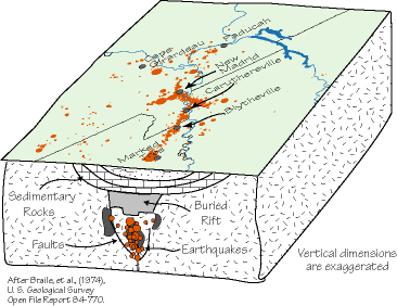
Plotting the location and depth of modern earthquakes, reveals
three trends. First, a right-lateral strike-slip segment
oriented to the northeast, from Marked Tree, Ar. to Caruthersville,
Mo, running parallel to the Reelfoot rift. Second, a stepover
(reverse) fault, known as the Reelfoot fault, just southwest of New
Madrid, Mo., running from the southwest, near the Tiptonville Dome,
to the northwest. The third trend, New Madrid North fault, is
another right-lateral strike-slip fault that extends northeast to
Cairo, Il. from the northwestern end of the reelfoot fault.

Two scales have been created to
describe the effects of earthquakes. The Richter Scale
is the measure of the magnitude
of seismic waves from an earthquake and measures how much the
ground shakes 60 miles from the earthquakes epicenter. The scale is
logarithmic; that is, the amplitude of the waves increases by
powers of 10 in relation to the Richter magnitude numbers.
The Modified Mercalli
Scale was
developed as a way of measuring
the actual effects or intensity of an earthquake at a particular
location, and is expressed in roman numerals from I the weakest to
XII the strongest. The intensity scale differs from the
Richter scale because the effects of an earthquake depend on
location from the epicentre and local geological conditions.
Whereas the Richter scale is the measurement of the magnitude of an
earthquake independent of location.
Modified Mercalli-Richter
Scale
| Intensity |
Verbal Description |
Magnitude |
Witness
Observations |
|
I
|
Instrumental
|
1 to 2
|
Detected only by seismographs |
|
II
|
Feeble
|
2 to 3
|
Noticed only by sensitive people |
|
III
|
Slight
|
3 to 4
|
Resembling vibrations caused by heavy
traffic |
|
IV
|
Moderate
|
4
|
Felt by people walking; rocking of free standing
objects |
|
V
|
Rather Strong
|
4 to 5
|
Sleepers awakened and bells ring |
|
VI
|
Strong
|
5 to 6
|
Trees sway, some damage from overturning and falling
object |
|
VII
|
Very Strong
|
6
|
General alarm, cracking of walls |
|
VIII
|
Destructive
|
6 to 7
|
Chimneys fall and there is some damage to
buildings |
|
IX
|
Ruinous
|
7
|
Ground begins to crack, houses begin to collapse and
pipes break |
|
X
|
Disasterous
|
7 to 8
|
Ground badly cracked and many buildings are
destroyed.There are some landslides |
|
XI
|
Very Disasterous
|
8
|
Few buildings remain standing; bridges and railways
destroyed;water, gas, electricity and telephones out of
action. |
|
XII
|
Catastrophic
|
8 or greater
|
Total destruction; objects are thrown into the air,much
heaving,shaking and distortion of the ground |
Earthquakes generate several
kinds of seismic waves including P, for "Primary" and S, for
"Secondary" waves. The P waves move in a compressional motion
similar to the motion of a slinky, while the S waves move in a
shear motion perpendicular to the direction the wave is
travelling. The precise
speed that a seismic wave travels depends on several factors, most
important is the composition of the rock . P-waves are the first
waves to arrive on a complete record of ground shaking because they
travel the fastest, typically 5-8 km/s. S waves, travel more
slowly, usually at 60% to 70% .
P -Waves 
S - Waves 
The
seismicity
map shows many earthquakes
in and around Kentucky between the years of 1990 and 2006.
You can find information about the most recent earthquakes from
the USGS
Earthquake Hazard Program.