What Makes A
Pothole?
The list of ingredients is pretty short. Bedrock. Turbulent
water. And the abrasive mixture that geologists call suspended
sediment. Start with bedrock. Without it, potholes won't form. Why?
Anything less rock-solid will simply be washed away. "Washed away"?
That's the key to understanding Ingredient #2. Potholes are carved
from rock, and moving water provides the energy. This leaves only
the suspended sediment. It provides the cutting tools for the job.
Three ingredients: rock, water, sediment. Three roles: medium,
muscle, tool. Nature as sculptor.
Let's spend a little more time on water. If you've ever capsized
in a big rapid or heavy surf, you've felt the power of moving
water. The faster water moves, the more power it has — and
the more power it has, the more suspended sediment it can carry
along with it. But fast-moving water doesn't flow quietly for long.
As soon as it meets an obstacle, it twists and turns, bending back
on itself and forming eddies, souse holes, whirlpools, and boils.
These macro-phenomena have micro counterparts: as bedrock is
roughened by the impact of transported sediments (a process known
as corrasion), the resulting turbulent flow generates subaqueous
vortices called kolks. These spin round like small tornadoes,
plucking material from the riverbed. And that's not all. The "white
horses" that make life lively for canoeists and kayakers are also
reproduced on a smaller scale beneath the surface. When stream
velocities are high, river-bottom turbulence generates bubble
trains that subsequently burst with explosive force. Over time,
these tiny explosions will pockmark even the hardest rock, in the
same way that cavitation pits the surface of high-speed
propellers.
This is all it takes. Each new irregularity generates more
turbulence, and every increase in turbulence breeds new
irregularities. The milling materials — sediments ranging in
size from silt to cobbles — then do their work, tirelessly
grinding away. Soon a cavity starts to form in what was once smooth
rock. A pothole is born.
Of course, what goes up must come down, right? Rivers in flood
are no exception. And when the high water recedes, hidden potholes
are exposed to view. This is especially true on steep, flashy
rivers — like the river that flows past the Niagara
Falls.
Ice Age History of the
Niagara River
The Niagara River, as is the entire Great Lakes Basin of which
the river is an integral part, is a legacy of the last Ice Age.
18,000 years ago southern Ontario was covered by ice sheets 2-3
kilometers thick. As they advanced southward the ice sheets gouged
out the basins of the Great Lakes. Then as they melted northward
for the last time they released vast quantities of meltwater into
these basins. Our water is "fossil water"; less than one percent of
it is renewable on an annual basis, the rest leftover from the ice
sheets.
The Niagara Peninsula became free of the ice about 12,500 years
ago. As the ice retreated northward, its meltwaters began to flow
down through what became Lake Erie, the Niagara River and Lake
Ontario, down to the St. Lawrence River, and, finally, down to the
sea. There were originally 5 spillways from Lake Erie to Lake
Ontario. Eventually these were reduced to one, the original Niagara
Falls, at Queenston-Lewiston. From here the Falls began its steady
erosion through the bedrock causeing many potholes.
However, about 10,500 years ago, through an interplay of
geological effects including alternating retreats and re-advances
of the ice, and rebounding of the land when released from the
intense pressure of the ice (isostatic rebound), this process was
interrupted. The glacial meltwaters were rerouted through northern
Ontario, bypassing the southern route. For the next 5,000 years
Lake Erie remained only half the size of today, the Niagara River
was reduced to about 10% of its current flow, and a much-reduced
Falls stalled in the area of the Niagara Glen.
About 5,500 years ago the meltwaters were once again routed
through southern Ontario, restoring the river and Falls to their
full power. Then the Falls reached the Whirlpool. It was a brief
and violent encounter, a geological moment lasting only weeks,
maybe even only days. In this moment the Falls of the youthful
Niagara River intersected an old riverbed, one that had been buried
and sealed during the last Ice Age. The Falls turned into this
buried gorge, tore out the glacial debris that filled it, and
scoured the old river bottom clean. It was probably not a falls at
all now but a huge, churning rapids. When it was all over it left
behind a 90-degree turn in the river we know today as the
Whirlpool, and North America's largest series of standing waves we
know today as the Whirlpool Rapids.
The Falls then re-established at about the area of the Whirlpool
Rapids Bridge upriver to our right, and resumed carving its way
through solid rock to its present location.
The Niagara is a fairly young river, only 12,000 years old!, a
microsecond in geological time. At the bottom of the Niagara falls,
the water travels 15 miles over many gorges until it reaches the
fifth Great Lake-Ontario. The land between the lakes does not slope
at an even grade, but forms a spectacular drop approximately the
same height as a 20 story building.
What You Need To Do
To Claim This Cache As A Find,
Please E-mail me the answers to the following
questions:
1. List the three ingredients that are required to make a
pothole?
2. In your own words, how do potholes form?
3. What great lake does the Niagara River empty into?
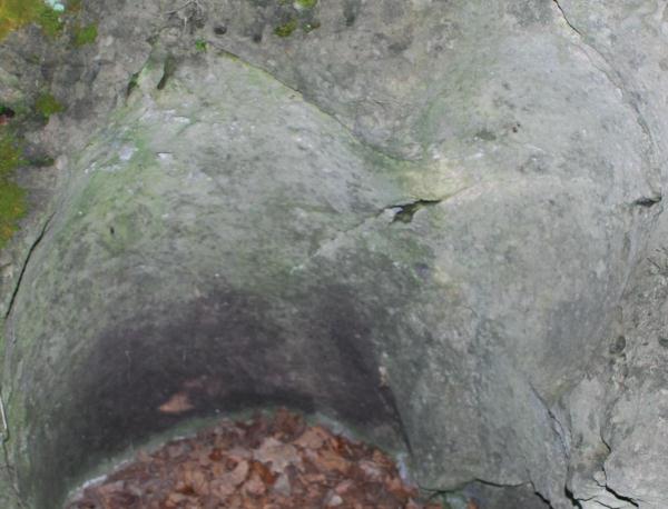
4. Estimate the height, width, and depth and the largest pothole in
the picture above, which is located at the posted
coordinates.
5. Estimate the elevation of the pothole shown above, which is
located at the posted coordinates.
Important Note -- the Niagara Glen is a Nature Reserve since
1992 that contains wild flora and fauna (plants and animals).
Please observe all posted regulations. Stay on the trails, that are
marked and follow generally accepted trail etiquette. Fires are not
permitted. Take only photos, leave only footprints! Niagara Parks
Act Regulations:www.niagaraparksnature.com