Harreser Erdfälle / Harreser sinkholes EarthCache
Harreser Erdfälle / Harreser sinkholes
-
Difficulty:
-

-
Terrain:
-
Size:  (not chosen)
Please note Use of geocaching.com services is subject to the terms and conditions
in our disclaimer.
Die Harreser Erdfälle / The Harreser
sinkholes
[DE]
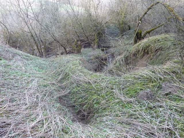
Diese Harreser Erdfälle zählen noch zu den wenigen aktiven Dolinen
in Süddeutschland. Ihre max. Tiefe beträgt stolze 8m. Die Objekte
befinden sich im Oberen Massenkalk. Sie liegen im Gewann
"Riedwiesen" gegenüber den keltischen Grabhügeln.
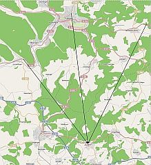
Das in den Dolinen versickerte Wasser taucht nach einiger Zeit in
der Aachquelle (Aach/Hegau) wieder auf. Das Entstehen von solch
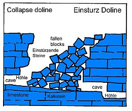
einer Grube, die Dolinenbildung, wird duch das Einstürzen von
riesigen Hohlräumen bewirkt, die sich unter der Erde als Folge von
Verkarstung im Laufe vieler Jahrtausende gebildet haben. Das Wasser
kann in die durchlässigen Gesteinsmassen eindringen und dadurch ein
weit verzweigtes Spaltensystem erschaffen, das, wie hier, bis in
die Aach führt, deren unterirdische Einzugsgebiet so auf etwa 250
bis 280 Quadratkilometer geschätzt wird. Die Harreser Erdfälle sind
Lebensraum für seltene Pflanzen- und Tierarten und als
flächenhaftes Naturdenkmal ausgewiesen. (Id: 6856)
Um den Cache zu loggen, habt ihr folgende Aufgaben:
a) Mache bitte ein Bild von Dir oder deinem GPS bei den Harreser
Erdfälle im Hintergrund ladet es in eurem Log hoch.
b) Auf der kleinen Infotafel ist die Rede von einer neuen
Vertiefung. Wann wurde sie entdeckt?
c) Was für ein Durchmesser hatte sie anfangs?
d) Woher kommt der Name Harreser?
Quellenangabe:
(c) Neuhauser Geschichtsverein
(b) Wikipedia.de
(c) Landratsamt Tuttlingen Geotope
(d) Open SreeetMap
Sende die Antworten an meine Emailadresse über mein GC Profil und
warte auf die Logfreigabe.
Nach der Logfreigabe, bitte nicht vergessen das Bild dem Log
anhängen.
Alles andere wird sofort gelöscht!
 |
 |
[DE] Einzugsgebiet der Aachquelle
[EN] catchment area of the Aachquelle |
[DE] Entstehung Einsturz Doline
[EN] Forming of Collaps Doline |
[EN]
The Harreser sinkholes are still one of the few active sinkholes in
Southern Germany. Its maximum depth averages 8m. The objects are
located in the upper limestone. They are in the area 'Riedwiesen'
adverse to the celtic barrows.
The water seeped into the sinkholes and appeared after some time in
the Aachquelle (Aach / Hegau) back. The emergence of such a pit
(the sinkhole education) is granted by the collapse of huge
cavities causes that have been formed under the earth as a result
of karstification in the course of many millennia.The water can
penetrate into the porous rock masses and thereby create an
extensive gap system, which as here leads to the Aach, whose
underground catchment area is estimated about 250 up to 280 square
kilometers. The Harreser sinkholes are habitat for rare plant and
animal species and declared as extensive natural monument. (Id:
6856)
To log the Cache, please resolve the following duties: a) Take a
picture from you or your gps with the background of Harreser
sinkholes and load it up in your log.
b) On the small info board is the speech of a new deepening. When
was it discovered?
c) What diameter had it in the beginning?
d) Where does the name „Harreser“ come from?
List of references:
(a) History Club of Neuhausen
(b) Wikipedia.de
(c) District Office Tuttlingen Geotope
(d) Open SreeetMap
Please send your answers to my E-Mail-Account through my GC-Profile
and wait for the Log-Approval.
After the Log-Approval, please don’t forgive to attach the
picture to the log.
Anything else will be deleted immediately!
Additional Hints
(No hints available.)