Dolina de Cedros

Esta Earthcache leva-nos a conhecer a Dolina de Cedros, uma das maiores dolinas da Serra da Boa Viagem. Está parcialmente edificada sobre arenitos do Jurássico Superior, mas a sua génese e evolução deve-se à existência de espessas camadas calcárias subjacentes que, ao sofrerem dissolução, permitiram o desenvolvimento de uma carsificação abaixo da superfície que levou à subsidência dos materiais superiores e, após a formação de algares e grutas, à própria absorção daqueles (Almeida,1998).
GEOMORFOLOGIA
A Serra da Boa Viagem apresenta cerca de 6 km de comprimento, uma direcção sensivelmente NW-SE e uma cota máxima de 257m na Bandeira.
Termina abruptamente nas vertentes setentrional e ocidental onde dominam as escarpas de natureza carbonatada, de que é exemplo a "Escarpa da Murtinheira" na vertente setentrional, que corresponderá a uma falha inversa, com eventual actividade quaternária - falha de Quiaios.
Esta falha, que limita o maciço a norte, terá contribuído para colocar em contacto terrenos margo-calcários do Liásico com areias eólicas quaternárias - Areias de Cantanhede.
Na vertente ocidental, as formações do Dogger e Malm formam a arriba litoral do promontório, que se encontra actualmente descaracterizada devido à actividade extractiva secular que se desenvolveu no local.
A transição para o flanco meridional processa-se de forma "suave", terminando com uma série cretácica greso-carbonatada, à qual se sobrepõem depósitos quaternários que marginam o estuário do Mondego.
FORMAÇÃO
Em relevos cársicos, as rochas são dissolvidas pela água ácida resultante da combinação da água da chuva com o Dióxido de Carbono (CO2) da atmosfera ou do solo. Ao passar por frestas da rocha, a água dissolve e carrega os minerais rumo ao lençol freático. Isso pode alargar as aberturas na rocha e formar cavernas e diversas outras feições no terreno. À medida que as rochas sob a superfície são dissolvidas, o terreno cede e formam-se dolinas ou outros tipos de vales. Muitas vezes, várias dolinas próximas se unem por erosão, formando úvalas
Dolinas de subsidência lenta
Também chamadas dolinas de dissolução. Quando a rocha é lentamente removida por infiltração em rachaduras o solo é rebaixado lentamente, sem formar cavidades subterrâneas. À medida que a rocha é removida o terreno pode ser rebaixado vários metros, formando grandes vales. Em muitos casos há exposição de rochas nas laterais da dolina. Podem ser inundadas, mas frequentemente são secas e apresentam vegetação em seu interior.
As Dolinas:
Quanto a sua génese, podem ser:
1. De Dissolução– quando rochas carbonadas sofrem, na superfície, corrosão e dissolução por águas ácidas provocando a formação de depressões normalmente mais larga que profunda. Em alguns casos, um percurso de água se forma para a profundidade, chamando-se, então, de dolinas aluviais;
2. De Colapsoou Abatimento – quando devido a presença de uma cavidade mais profunda, ocorre o desabamento de seu teto, surgindo uma depressão na superfície, que pode ou não, se comunicar com o interior da cavidade.
Evidentemente, o tipo um e dois podem associar-se.
Quanto a sua forma, podem ser:
1. Tigela– largura dez vezes maior que a profundidade, bordas pouco inclinadas, e fundo plano;
2. Funil – diâmetro duas a três vezes maior que a profundidade, bordas bem inclinadas e fundo estreito;
3. Poço– diâmetro bem menor que a profundidade, bordas quase verticais, fundo com diâmetro próximo a abertura;
4. Caldeirão– largura, fundo e profundidade com tamanhos próximos;
5. Dolina em Trincheira – tipo peculiar com comprimento muito maior que a largura, provocado por desabamento de longo trecho de cavernas e galerias, podendo, quando muito longo, formar um cannyon de desabamento.
Quanto à presença de água, podem ser:
1. Secas;
2. Húmidas
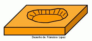
|
Esquema da estrutura de uma dolina.
|
|
|
|
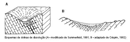
Esquemas de dolinas de dissolução (A e B).
|
|
|
Para logar esta Earthcache enviem-nos um e-mail com a resposta ás seguintes questões:
1 - Qual o tipo de Dolina presente naquele local?
2 – Qual o diâmetro aproximado da Dolina?
3 - Qual a altura da Dolina?
No seu log publique uma fotografia sua no local, com o seu GPSr.
Sinkhole
This Earthcache leads us to know the Dolina of Cedros, one of the largest dolines on Serra da Boa Viagem. Is partially built on the Upper Jurassic sands, but its genesis and evolution is due to the existence of thick layers of limestone underlying that, suffer dissolution, allowed the development of a carsificação below the surface which led to subsidence of the upper materials and, after the sinkholes and caves, the actual absorption of those (Adams, 1998.)
GEOMORPHOLOGY
Serra da Boa Viagem is approximately 6 km long, roughly one direction NW-SE and a maximum height of 257m in the Miradouro da Bandeira.
Ends abruptly in the northern and western slopes which dominate the carbonate scarps nature, as exemplified by the "Escarpment of Murtinheira" in the northern part, which correspond to a reverse fault, with the possible quaternary activity - failure Quiaios.
This failure, which limits the mass to the north, have contributed to putting land into contact margo-lime Liásico with the Quaternary aeolian sand - Sands Cantanhede.
On the western side, the Dogger and Malm formations form the coastal cliffs of the headland, which is currently uncharacterized due to secular extractive activity which has developed on the site.
The transition to the southern flank takes place in a "mild", ending with a series-Cretaceous carbonate grains, which overlap Quaternary deposits that border the estuary of Mondego.
In karstic reliefs, the rocks are dissolved by acid water resulting from the combination of rain water with carbon dioxide (CO2) from the atmosphere or soil. By going through the rock cracks, the water dissolves and carries the minerals into the groundwater. This can widen the gaps in the rock to form caves, and several other features on the ground. As the rocks under the surface are dissolved, the land yields and formed sinkholes or other types of valleys. Often, several nearby dolines unite by erosion, forming Uvala
Subsidence dolines slow Also called dolines of dissolution. When the rock is slowly removed by infiltration into cracks the ground is lowered slowly, without forming underground cavities. As the rock is removed from the ground can be lowered several feet, forming large valleys. In many cases there is exposure of rocks on the sides of the doline. May be flooded, but are often dry and vegetation present in it.
A sinkhole, also known as doline, is a natural depression or hole in the earth's surface caused by karst processes - the chemical dissolution of carbonate rocks. Sinkholes may vary in size from less than 1 to 300 meters (3.3 to 980 ft) both in diameter and depth, and vary in form from soil-lined bowls to bedrock-edged chasms. They may be formed gradually or suddenly, and are found worldwide. These terms are often used interchangeably, though many distinguish between features a surface stream flows into and features with no such input.
The mechanisms of formation involves natural process of erosion or gradual removal of slightly soluble bedrock (such as limestone) by percolating water, the collapse of a cave roof, or a lowering of the water table. Occasionally a sinkhole may exhibit a visible opening into a cave below. In the case of exceptionally large sinkholes, such as Cedar Sink at Mammoth Cave National Park, USA, a stream or river may be visible across its bottom flowing from one side to the other.
The sinkholes are common where the rock below the land surface is limestone, carbonate rock, salt beds, or rocks that can naturally be dissolved by circulating ground water. As the rock dissolves, spaces and caverns develop underground. These sinkholes can be dramatic because the surface land usually stays intact until there is not enough support. Then, a sudden collapse of the land surface can occur.
Sinkholes can be human-induced and new sinkholes have been correlated to land-use practices, especially, from ground-water pumping, construction, and development practices. They can also form when natural water-drainage patterns are changed and new water-diversion systems are developed. Some sinkholes form when the land surface is changed, such as when industrial and runoff-storage ponds are created; the substantial weight of the new material can trigger an underground collapse of supporting material, thus, causing a sinkhole
The Sinkhole:
As for its origins can be:
1. Dissolution of carbonate rocks, when they suffer, on the surface, corrosion and dissolution by acidic waters resulting in the formation of depressions usually wider than deep. In some cases, a path is formed for water depth, calling, then, of alluvial dolines;
2. Abatement of Colapsoou - when due to the presence of a cavity deeper, there is a collapse of its ceiling, appearing a depression on the surface, which may or may not communicate with the cavity.
Obviously, the type one and two can join.
As to its form may be:
1. Bowl-width ten times greater than the depth, edges slightly bowed, and plan fund;
2. Funnel - diameter two to three times the depth, edges and steep and narrow bottom;
3. Well-well diameter smaller than the deep, almost vertical edges, bottom diameter near the opening;
4. Cauldron-width, depth and bottom sizes coming;
5. Dolina in Trench - peculiar type with a length much greater than width, caused by collapse of long stretch of caves and galleries, may, when very long, form a Canyon of collapse.
Regarding the presence of water may be:
1. Droughts;
2. Wetlands
To log this earthcache send us an email with the answer to the following questions:
1 - What kind of Dolina at this location?
2 - What is the approximate diameter of Dolina?
3 - What is the height of Dolina?
In your log publish a photo with your GPSr.