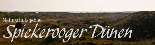
Naturschutzgebiet Spiekerooger Dünen EarthCache
Naturschutzgebiet Spiekerooger Dünen
-
Difficulty:
-

-
Terrain:
-
Size:  (not chosen)
Please note Use of geocaching.com services is subject to the terms and conditions
in our disclaimer.
 Eine Düne ist eine Erhebung aus Sand, die vom Wind angeweht und
abgelagert wird. Die Bildung von Dünen setzt das Vorhandensein von
Sand und das Fehlen einer geschlossenen Pflanzendecke voraus. Dünen
bilden sich daher bevorzugt in trockenen (ariden) Klimazonen,
können aber auch in humiden Gebieten auftreten, sofern die
befestigende Vegetation beseitigt wurde. Wird der Sand eher
gleichmäßig in Form einer Decke aufgeweht, spricht man neutral von
Flugsand. Mehr Informationen zu Dünen gibt es bei
Wikipedia
Eine Düne ist eine Erhebung aus Sand, die vom Wind angeweht und
abgelagert wird. Die Bildung von Dünen setzt das Vorhandensein von
Sand und das Fehlen einer geschlossenen Pflanzendecke voraus. Dünen
bilden sich daher bevorzugt in trockenen (ariden) Klimazonen,
können aber auch in humiden Gebieten auftreten, sofern die
befestigende Vegetation beseitigt wurde. Wird der Sand eher
gleichmäßig in Form einer Decke aufgeweht, spricht man neutral von
Flugsand. Mehr Informationen zu Dünen gibt es bei
Wikipedia
Die Randdünen bieten der Insel Spiekeroog einen natürlichen Schutz
gegen die Nordsee. Bei einer Sturmflut sind sie direkt von der
heranrollenden Brandung betroffen. Der Sand wir aus dem Dünenfuss
herausgespült: Eine Abbruchkante entsteht.
Die Dünenpflanzen fangen den Flugsand wieder auf und können so die
Düne wieder aufbauen. Die wenigen Pflanzenarten die sich an diesem
schwierigen Standort behaupten können, sind auf die ständige
Übersandung angewiesen und an die gelegentliche Überspülung
angepasst. Sie sind gegenüber Kälte und Wärme sehr resistent aber
nicht trittfest, was man an den Dünenüberwegen leicht sehen
kann.
Deshalb dürfen Dünen nur auf den gekennzeichneten Wegen betreten
und überquert werden. In der Vergangenheit wurden die Dünen durch
Tittschäden und Weidevieh so stark zerstört, dass das Dorf aus
nordwestlicher Richtung überflutet zu werden drohte.
Dünendurchbrüche wurden immer wieder geschlossen. Um 1700 begann
man, Strandhafer anzupflanzen, der in Dünen natürlich vorkommt, sie
festigt und weiter wachsen lässt. Später setzte man zusätzlich
Buschzäune ein um die Dünen weiter aufzubauen. Diese Aufgaben
übernimmt heute das Staatliche Amt für Insel- und
Küstenschutz.
|
| |
A dune is a collection of sand that is blown by the wind and
deposited. The formation of dunes is the presence of sand and the
lack of advance of a closed plant cover. Dunes are therefore
preferred in dry (arid) climate zones, but can also occur in humid
areas, where the attachable vegetation was removed. If the sand
more evenly aufgeweht in the form of a ceiling, it is called
neutral by shifting sand. More
Information on Wikipedia
The edge of the dunes provide a natural protection against
Spiekeroog the North Sea. In a storm, they are directly affected by
the oncoming waves. The sand dunes we flushed out from the foot: A
drip line is created.
The dune plants trap the sand again, and can build up the dune
again. The few plants that can stand their ground on this difficult
site, are dependent on the constant and be duly adjusted to the
occasional rinsing. They are very resistant to cold and heat but do
not crush resistant, which can be easily seen on the dunes
crossings.
Therefore, dunes may be entered and crossed only on the marked
trails. In the past, the dunes by Tittschäden and grazing livestock
were destroyed so much that the village threatened to be flooded in
a northwesterly direction. Dune breakthroughs were closed again. In
1700 they began to plant beach grass, which occurs naturally in
sand dunes, they can consolidate and grow. Later, Bush also sat
down to build a fence on the dunes. This task is taken today, the
National Agency for island and coastal protection. |
|
Um Loggen zu dürfen musst du folgende Aufgaben
erfüllen:
|
|

- Mit welchem Naturgesetz kann die Bildung von Dünen erklärt
werden? (Wikipedia)
- Nenne die fünf Dünenabschnitte (versch. Infotafeln auf der
Insel).
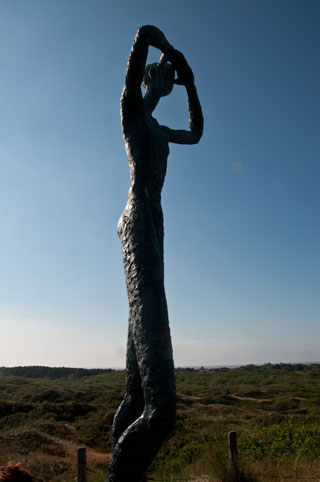
- Gehe zu den genannten Koordinaten und finde die Statue links
auf dem Bild und mache dort ein Foto von dir oder deinem GPS mit
der Statue.
- Wie heißen die drei Schutzzonen der Dünen im
Nationalpark?
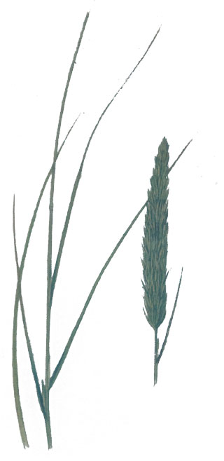
- Welche Pflanze ist auf dem Unteren Bild zu sehen?
- Sende uns deine Antworten per Mail.
(Logeinträge ohne Logfreigabe werden gelöscht)
|
|

- By what law of nature can be explained by the formation of
dunes? (Wikipedia)
- Name five dune sections (different Infotable around the
Island).
- Go to the given Coordinates and find the statue left of the
picture and then make a picture of yourself or your GPS with the
statue.
- What are the three protected areas of the dunes in the National
Park?
- What plant is shown on the lower picture?
- Send us your answers by mail.
(Without log entries log release will be deleted)
|
 |
|
Additional Hints
(No hints available.)