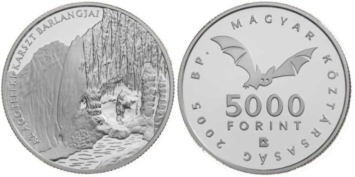

Cave Szabadság /
Szabadság-barlang
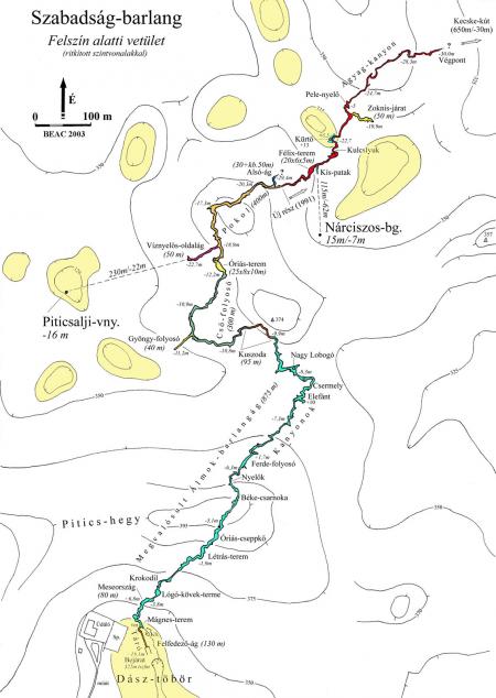
[EN]: The entrance of the cave is in the Dász doline at 322
metres above sea level. Its length is 3219 metres, this way it is
the third longest cave in the Aggtelek Karst region. It has been a
strictly protected cave since 1982. The system was formed in
Triassic limestone and dolomite. Influenced by the base rock
changes the cave comprises ??? distinctive sections. The narrow
meandering passage is followed by a filled up crawling stretch,
then narrow “key-hole” parts and later spacious, richly
decorated halls are characteristic. The main passage was primarily
formed by a stream, which recently is active only temporarily, and
contributes to the catchment area of the Kecskekút springs, this
way of the Jósva stream. The most speleothems can be found in the
first 900 metres. This part of the cave is richly decorated with
stalactites, stalagmites, draperies, soda straws and eccentrics.
The average temperature in the cave is 9,8
°C, cave humidity is about 99-100%.
The first exploration took place in ???, when local villagers started to dig
the sinkhole in the Dász doline. The actual breakthrough was the
expedition of the Kinizsi Caving Group lead by Dr. Dénes Balázs on
15th November 1954. The next major exploration was
carried out by József Frecska and Mrs. Zoltán Vidics in 1991, they
explored an additional 502 metres section of the
system.
The cave can be visited exclusively by trained
cavers with the permit issued by the Aggtelek National
Park.
Access to the cave: The cave is easily accessible from village Egerszog on the
concrete road. You can park your car near the Guest
House.
To claim this earthcache
please send me via profile e-mail the answer to the following
questions:
1) How many distinctive sections comprises the cave?
2) In which year took place the first exploration
of the cave?
Please don’t give the answers in your log
even encrypted! Please note that the logs which will not comply
with the above mentioned requirements will be deleted!
Uploaded photos with you and/or your GPS in the background with the
cave entrance are welcome.
Free Hungarian GPS unit digital map means 'hiking
trail' (turistatérkép) program from here downloadable.
[HU]:
A Dász-töbörben, 322 m tszf. Magasságban nyíló felszín alatti
rendszer 3219 m hosszával az Aggteleki-karszt harmadik leghosszabb
barlangja. A triász idoszaki mészkoben és dolomitban húzódó foághoz
néhány kisebb mellékág csatlakozik. Az 1982 óta fokozott védelem
alatt álló barlang morfológiája a befoglaló kozet-típusok változása
szerint ??? jellegzetes
szakaszra osztható. A szuk, kanyargós (meanderezo) folyosót erosen
feltöltött kuszoda, majd szuk, kulcslyukszelvényu szorítókból ás
szépen díszített tágas termekbol álló rész váltja fel. A járatok
kialakulásában jelentos szerepet játszott a ma már csak idoszakosan
aktív patak, melynek vize a Jósva-patak vízrendszeréhez tartozó
Kecskekút-forrásban jelenik meg. Ásványkiválásokban az elso,
mintegy 900 méteres szakasza a leggazdagabb, ahol függo- és
állócseppkövek, cseppkozászlók, retek- és szalmacseppkövek, és
különösen sok görbe cseppko (heliktit) fordul elo. A barlang
levegojének évi középhomérséklete 9,8 °C, ami csak néhány tized
fokot ingadozik, páratartalma 99-100%.
A Dász-töbör fo víznyelojének bontását
???-ben égerszögi lakosok
kezdték meg, de a barlangba az Élelmiszeripari Minisztérium Kinizsi
Barlangkutató Csoportjának tagjai, dr. Balázs Dénes vezetésével
1954. november 15-én jutottak be. 1991-ben az addig ismert
szakaszok hossza Frecska József és Vidics Zoltánné feltáró munkája
nyomán 502 méterrel nott.
A barlang kizárólag az Aggteleki Nemzeti Park
Igazgatóság engedélyével, barlangjárásban gyakorlottak számára
látogatható.
Megközelítés: A
barlang legegyszerubben Égerszögbol közelítheto meg, aszfaltozott
erdei úton. Parkolni a közeli panziónál lehet.
Az earthcache logolásához
kérlek küldd el e-mailben a válaszokat a következo
kérdésekre:
1) Hány jellegzetes szakaszra oszthetó a barlang
morfológiája?
2) Melyik évben kezdodött meg a barlang elso
felderítése?
Kérlek ne add meg a válaszokat a logodban!
A feltételeknek nem megfelelo logokat
törölni fogom!
Ha van kedved, tölts
fel fotót magadról és/vagy a GPS-edrol, a barlang bejáratával a
háttérben.