You can walk here from Sandwood bay and that would qualify as a 5 star terrain rating.
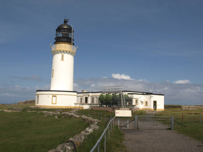
Most visitors arrive by boat and bus to the lighthouse but that is an epic journey also and still deserves its 5 star rating.
At the time of publishing the boat trip cost £5.50 and the bus £11.00 return journeys per person and worth every penny.
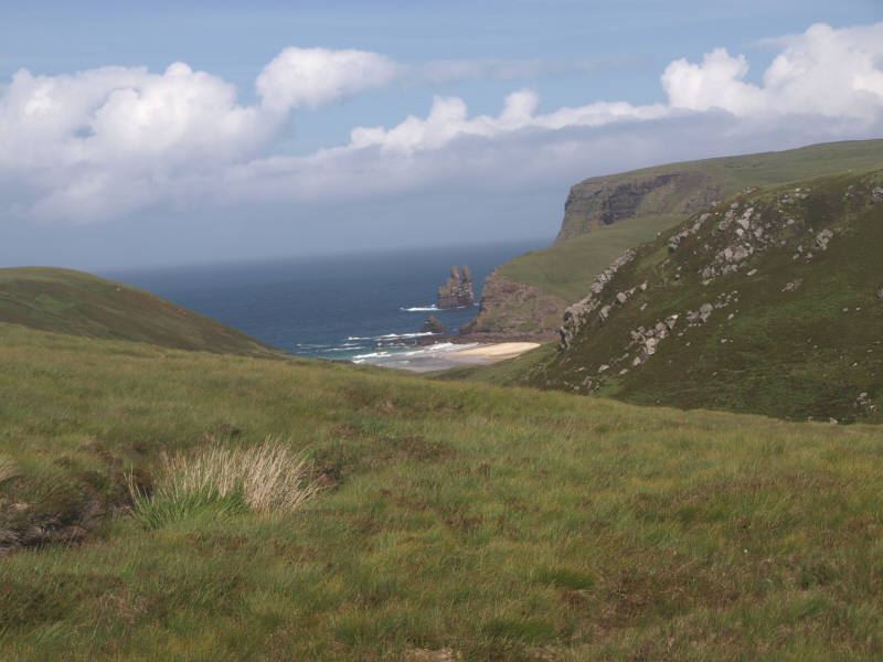
The land between the village and the lighthouse is known as the Parph, two hundred and seven square kilometers of moorland. The first road in the district, built in 1828 by the lighthouse commission, was constructed across the Parph to Britain's most north westerly point. The Cape Wrath road is rough but has some magnificent views. From the bus, several interesting landmarks can be seen.
The bus trip takes approximately half an hour each way, the entire excursion takes approximately 2 and a half hours. During the crossing amongst the beautiful scenery you are likely to see Common Seals. Daill beach is beautiful secluded spot easily accessed from the ferry point.
From 1935 to 1938 there were around thirty five people living on the Cape Side and apart from the lighthouse keepers, all the men were shepherds working for two local farms. There were ten children attending the school which was last used in 1947. Once there was a thriving population in this now desolate area, a world of difference to the Cape Wrath of nowadays.
A large area of Cape Wrath is used as an MOD bombing and targeting range. Although access is allowed to Cape Wrath, there are restrictions when exercises are taking place.
At the point is Cape Wrath Lighthouse which was built by Robert Stevenson in 1828 on the most northwesterly tip of the Scottish mainland. The name of the headland derives, not from the stormy waters of the area but from the Norse word for a turning point, for here the Norsemen turned their ships to head for home.
Geological info.
Cape Wrath is Britain's most north westerly point.
Cape Wrath and Cape Cornwall at completely the other end of the UK, are the only two Capes in Britain.
The land between Durness and the lighthouse is known as The Parph and contains 207 square kilometers of moorland designated as a "Site of Special Scientific Interest".
The Clo Mor cliffs are the highest cliffs on the British Mainland. These Torridonian Sandstone cliffs are a major breeding site for sea birds in the United Kingdom.
This area encompasses some of the finest mountain and coastal landscapes in Britain and contains a wealth of classic geological localities. The pristine beaches of Sandwood and Balnakiel, and dramatic coastal cliffs at Cape Wrath, mainland Scotland’s most north westerly point.
Lewisian Gneiss
An area of NW Highlands Geopark known as ‘The Foreland’ lies to the west of the Moine Thrust Zone and includes most of the coastal townships. The Foreland is largely made up of Lewisian Gneiss, which at 3000 million years old is the oldest rock type in Britain.
Because they were once part of the same continent, the same rock type is found in North America and Greenland. The rock has been eroded and scoured by glaciers to form the many hillocks (‘cnoc’) and small lakes (‘lochans’) typical of the north west. Here the Lewisian Gneiss is overlaid with Torridonian Sandstone.
Torridonian Sandstone
The rocks around the north of were formed some 1000 million years ago. It is Torridonian Sandstone which is a sedimentary type.
Sedimentary rock starts out as little grains carried along in rivers and streams and is built up of many layers of sediment, eventually becoming compacted under the weight of layers above until it becomes rock. Erosion along the coast has exposed these rocks.
There are eight Marilyns located within the Cape Wrath peninsula.
Marilyns are British hills of any height with a drop of at least 150 metres on all sides.
Farrmheall 521m 1709ft
Creag Riabhach 485m 1591ft
An Grianan 467m 1532ft
Fashven 460m 1509ft
Sgribhis-bheinn 371m 1217ft
An Socach 362m 1188ft
Ghlas-bheinn 333m 1093ft
Beinn Akie 288m 945ft
To claim this cache please do both of the following:
(1) Post a photo of yourself or your GPSr in front of the lighthouse, bus or cafe.
The guidelines for geocaching say -
While photographs may be requested, they do not take the place of other logging requirements. Taking a photograph alone does NOT meet these logging guidelines. Requests for a photograph will be considered an additional logging requirement and must be optional.
I think you will want to take a picture anyway.
(2) Answer the following questions:
a. What is the height of the highest cliffs?
b. Standing on the Foghorn Platform, can you tell me what type of rock forms the island, Stac an Dunain which is in front of you?
Please do not include your answers in your log, instead email me with your findings.
If I do not receive the answer and a photo (optional ) is not posted, you may have your log deleted..... Educational guidelines for Earthcaches are set by Geocaching.com and GeoSociety.org (Earthcache) and have to be adhered to.
Cache placed with the kind permission of the Northern Lighthouse Board.