 German:
Der
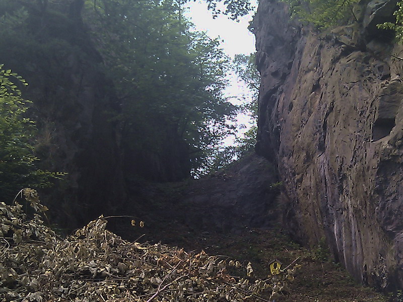
Trusetaler Hauptgang ist eine Station des Geopark Thüringen. Am
nördlichen Ausläufer von Trusetal, kurz vor dem bekannten
Trusetaler Wasserfall durchbricht eine imposante Schlucht die
Berge. Diese enstand erst mit Einzug des Bergbaus in diese Region.
Zum Abbau des Ganggestein kam es aufgrund der einfachen Art des
oberirdischen Abbau. Dadurch entstand die sogenannte
"Porphyrschlucht".
Vor vielen
Millionen Jahren durchschlugen hier die Ganggesteine den harten
Granit. Als geologische Besonderheit im Trusetaler Raum, treten
hier im Fels gemischte Gänge auf. Dabei handelt es sich um mehrere
Ganggesteine nebeneinander, welche ihren Namen ihrer Entstehung
verdanken. Das Gestein stieg aus großer Tiefe in schmalen Gängen
zur Erdöberfläche auf und blieb dort in schmalen Spalten stecken.
Aufgrund dieser Tatsache weisen diese Gesteine, obwohl sie an der
Erdoberfläche zu finden sind, trotzdem die Merkmale von
Tiefengestein und Ergussgestein auf.
Zum
Cache
- Welches Gestein trennt den Granit vom
aufgestiegenen Syenitporphyr = A
- Vor wieviel Millionen Jahren durchschlugen
die Ganggesteine den Granit = B
- Was wurde aus dem abgebauten Gestein noch
hergestellt außer Pflastersteinen = C
Um den Cache loggen zu dürfen schickt bitte die Antworten an
"ABC@gmx.de" (z.B. Stein500Pflasterstein@gmx.de). Bei richtiger
Antwort bekommt ihr umgehend die Logerlaubnis. Da ich mich für die
Cacher vor Ort interessiere, bitte ich euch ein Bild, von euch und
eurem GPS vor der Porphyrschlucht, dem Log beizufügen.
Geologische Grüße und viel Spaß wünscht "Wolle [CR]"

 English:
The "Trusetaler Hauptgang"
is a station of the "Geopark Thuringia". At the northern
foothills of Trusetal, just before the famous water falls breaks
through an impressive gorge of the mountains. This was recently
completed with the arrival of the mining industry in this
region. To reduce the speed of rock
came about because of the simple nature of the surface
degradation. This created the so-called
"Porphyry Gorge".
Many millions of years ago
pierced the dykes the hard granite. As a geological feature in
Trusetal, come here on the rock joint operations.
It
will consist of several parallel dykes which owe their name their
creation. The rock rose from deep in
narrow corridors on the Earth's surface and stayed stuck in narrow
columns. Due to this fact, these
rocks, although they can be found at the surface, but the
characteristics of rocks and volcanic rock at
depth.
To cache:
1.
What
separates the granite rock from the Ascended Syenitporphyr =
A
2.
How many million years ago pierced the dykes of the
granite = B
3.
What
became of the mined rock still made out of cobblestones = C
To log the cache may please
send the answers to "ABC@gmx.de" and wait for the log
permission. Then Log conditions are not
allowed, but I'm looking for the cacher on the spot, I ask you a
picture, accompanied by you and your GPS in front of the porphyry
Gulch, Log.
Geological regards and much fun wishes "Wolle
[CR]"