[PT] Caldeira - Ilha do Faial
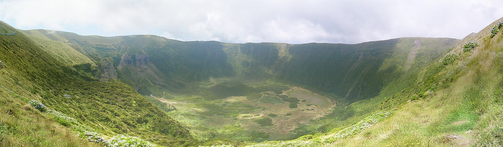
Esta cache irá conduzi-lo à maior cratera vulcânica da Ilha do Faial.
Está localizada no coração da ilha e é em grande parte responsável pela atual formação paisagística da ilha.
Está classificada como reserva natural desde 1982 é o habitat natural de várias plantas e animais endémicos.
A idade deste vulcão ronda os 400 mil anos e a sua última erupção foi à cerca de 1000 anos. Desde entao que a estrutura da cratera tem permanecido quase inalterada apesar de nas encostas a norte e este mostrarem claros sinais de desmoronamentos. Alguns (como o ocorrido durante o sismo de 9 de Julho de 1998) ocorreram depois da colonização da ilha.
Já existiu uma lagoa permanente no centro da cratera, mas a atividade sísmica gerada pela erupção do vulcão dos Capelinhos (1958) criou fissuras que levaram ao escoamento das águas.
No local da cache pode apreciar tanto a vista para a cratera como para a ilha. Em dias de céu limpo também poderá ver a ilha vizinha do Pico, que é (no seu topo) o ponto mais alto de Portugal.
Este é também o local para dar início ao trilho dos 10 vulcões. Um trilho com 21km que se inicia no ponto desta cache e termina no vulcão dos Capelinhos no lado oeste da ilha. Este trilho tem uma duração média de 6 horas e agrega 3 trilhos, pode obter mais informação nas placas informativas no local, ou nesta página.
A Cache
Para efetuar o log nesta cache é necessário responder corretamente às seguintes questões. (Não é necessário aguardar pela a minha aprovação, mas poderei apagar os logs que tiverem respostas incorretas)
1. Qual o diâmetro da cratera?
2. Qual a altura, desde o nível do mar até à base da cratera?
3. Qual a altura desde a base da cratera até ao topo das sua encosta mais elevada?
4. O que é a "Rocha do Altar"?
Pode também juntar ao log uma fotografia no local (opcional).
[EN] Caldeira - Faial Island
This cache takes you to the biggest volcano crater in Faial Island.
It's located in the heart of the island and it's of great importance in the formation of the present landscape of the island.
It was established has a natural reserve since 1982 and it's the habitat of several endemic plants and animals.
This volcano has 400 thousand years old and it's last eruption was about 1000 years ago. Since then the shape of the crater has remain almost unchanged although its eastern and northern slopes show clear signs of multiple landslides, some of which (like the one which resulted of the earthquake in July 9, 1998) has occurred since the settlement of the island.
There was once a permanent lagoon in the center of the crater, but the sismic activity generated from the Capelinho's volcano eruption (1958) created fissures that led to the draining of the waters.
From the place of the cache you can enjoy a view of both the crater and the island. In clear days you can also see the neighbour island of Pico, which is (at the top) the highest point of Portugal.
This is also the place to start the "10 volcanos" trail. A walking trail of 21km that starts at the point of this cache and ends in the Capelinhos volcano on the western side of the island. It's a 6 hours trail of medium-high difficulty and comprehends 3 trails. You can get further information in the boards available at the site or in this webpage.
The Cache
To log this cache you must email me the answers to the following questions. (No need to receive feedback from me, but I may delete the log if wrong answers are given)
1. What is the diameter of the crater?
2. What is the height from sea level to the bottom of the crater?
3. What is the height from the bottom of the crater to the top of its highest slope?
4. What is the "Rocha do Altar"?
Optionally, you can post a photo of yourself at the given coordinates in the log.