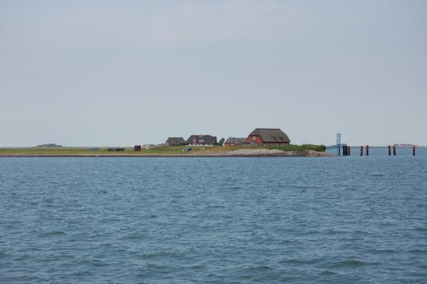
Die Rixwarf / The Rixwarf
Deutsch:
Kurze Beschreibung zu Langeneß:
Langeneß ist die größte Hallig mit 16 Warften auf denen rund 100
Menschen wohnen. Die Hallig ist ca. 10 km lang und ca. 1,4 km breit
und war vor der 2. Großen Sturmflut fest mit der Hallig Oland
verbunden. Die Hallig Langeneß liegt im Nordfriesischen Wattenmeer
zwischen Föhr, Amrum und Pellworm. Mit einer Fähre die regelmäßigen
nach Langeneß fährt ist die Hallig zu erreichen. Außerdem existiert
eine nur bei Niedrigwasser nutzbare Lorenbahnverbindung durch das
Wattenmeer zur Hallig Oland, und von dort aus weiter zum
Festland.
Theodor Storm nannte die Halligen „Schwimmende Träume“.
Wenn man hier ankommt kann man das durchaus nachvollziehen. Es
scheint die Zeit langsamer zu gehen.
Geologisch:
Die geologisch-morphologischen Verhältnisse der nordfriesischen
Inseln wurden ganz wesentlich durch die letzten Eiszeiten
geprägt.
Während der Kaltzeiten (Glazial) rückten die Gletscher aus dem
skandinavischen Raum vor. Durch die Vereisung wurden enorme
Wassermengen der Meere gebunden, was im Laufe der Zeit zu einer
drastischen Absenkung des Meeresspiegels führte.
In dem Zeitabschnitt Pleistozän der Erdgeschichte waren die drei
Inselkerne von Amrum, Föhr und Sylt sowie die Halligen noch
miteinander verbunden und bildeten das sogenannte "Westland".
Vor ca. 70.000 Jahren, während der letzten Eiszeit, sank der
Meeresspiegel erneut um einen Betrag von ca. 100 m gegenüber dem
heutigen Niveau ab. Am Ende des Pleistozäns kam es schließlich zur
Aufspaltung des "Westlandes". Zwischen den heutigen Inseln
Amrum
und Föhr entstand infolge des Abschmelzens der Inlandseismassen
eine Schmelzwasserrinne.
Der erneute Meeresspiegelanstieg im Zeitabschnitt Holozän auf das
heutige Niveau führte schließlich zur endgültigen Teilung des
ursprünglich zusammenhängenden "Westlandes". Es entstanden die
Inseln Amrum, Föhr und Sylt sowie die Halligen. Dementsprechend
besitzen auch alle drei Inseln einen pleistozänen Untergrund, der
sogenannte Geestkern.
Von besonderer Bedeutung für die heutige Gestalt und Position der
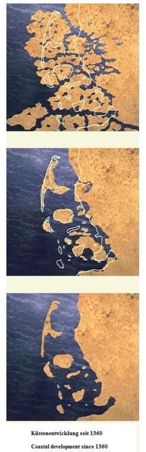
Inseln und Halligen waren die beiden Sturmfluten
(Mannsdränke),
die mit katastrophalen Landverlusten verbunden waren. An vielen
Stellen waren infolge von Austorfung zur Gewinnung von Salz größere
Senken entstanden, so dass das Meer bei Sturmflut leichtes Spiel
hatte.
Erst als die alten, maroden Deiche im Nachhinein verbessert und
erhöht wurden, konnten die Landverluste gestoppt und wieder Neuland
gewonnen werden.
Die Halligen sind kleine, nicht eingedeichte Inseln im
nordfriesischen Wattenmeer an der Nordseeküste Schleswig-Holsteins.
Die Besonderheit einer Hallig besteht darin, dass sie während einer
starken Flut mit Ausnahme der Warften (künstlich aufgeschütteten
Hügeln), auf denen die Häuser stehen, überspült wird.
Umgangssprachlich: „Landunter“.
Sie liegen inmitten des Nationalparks Schleswig-Holsteinisches
Wattenmeer, seit 2009 sind sie Weltnaturerbe Wattenmeer und sie
sind Teil des Biosphärengebietes Schleswig-Holsteinischen
Wattenmeer und Halligen.
Halligen bestehen aus Schwemmland, das oft nur eine dünne Schicht
über älteren Mooren bildet. Dieses Schwemmland bildete sich aus
maritimen Sedimenten, die sich ablagerten, während der Wasserstand
der Nordsee stieg. Dabei sogen sich die Moore mit Salzwasser voll
und starben ab. Der Boden senkte sich, wonach sich durch häufige
Überflutungen neue Sedimente ablagerten. Durch gleichzeitige
Erosion veränderte sich die Form dieses Schwemmlandes dauernd.
Übrig blieben Landfetzen, „Halligen“, auf denen die
Überlebenden sich niederließen. Bedingt durch die häufigeren
Überschwemmungen gab es weiterhin große Veränderungen an der
Küstenlinie.
Sehenswertes auf Langeneß:
• Museum: Das KAPITÄN TADSEN MUSEUM ist ein Original
erhaltenes Hallighaus, dessen
Grundstein im Jahre 1741 gelegt wurde.
• Kirche: Auf der Kirchwarft. Daneben das Gemeindehaus und die
Schule
• Schienenverbindung: Mit der Lorenbahn bzw. der
Segelohre
Die Aufgaben:
Beantworte die folgenden Fragen und sende die Antworten an die
folgende Mailadresse:
falkhunt@googlemail.com
Auf eine Logerlaubnis braucht nicht gewartet werden. Ich werde mich
melden, wenn Antworten nicht richtig sind.
1.) In welchem Jahr war die 2. Große Sturmflut (große Mandstränke)
bei der viele der Halligen und die Küstenlinie entstanden
sind?
2.) In der Nähe der Koordinaten befindet sich eine Übersicht der
Hallig Langeneß. Wie weit ist es von hier bis zum Lorenplatz (in
km, entspricht in etwa der Länge der Hallig, siehe Tafel) und wie
groß ist die Fläche der Hallig Langeneß in Quadratkilometern
(Schätzen, Fragen)?
3.) Wie heißt der salzhaltige Boden aus dem die Hallig
besteht?
• An der Rixwarf (an der Anlegestelle der Fähre) befindet sich
ein Naturstein. Mache dort mit der Rixwarf im Hintergrund ein Bild
von Dir. (Bitte dieses Bild mit loggen, ist aber nach den neuen EC
Regeln nicht mehr Logbedingung)
• Mache ein Bild einer der 16 Warften (von Dir frei wählbar)
auf Langeneß! (Bitte dieses Bild mit loggen, ist aber nach den
neuen EC Regeln nicht mehr Logbedingung)
Hinweis: Es handelt sich um ein Naturschutzgebiet und die
offiziellen Wege müssen zu keiner Zeit verlassen werden um den
Earthcache zu lösen. Bitte verhaltet Euch entsprechend.
Weitere Infos:
http://www.langeness.de
http://www.halligen.de

Die Kirche / The Church
English:
Short description of Langeness:
Langeneß is the largest Hallig with 16 Warften on which live about
100 people. The Hallig is about 10 km long and about 1.4 km wide
and was before the 2nd large storm flood connected to the Hallig
Oland. The North Frisian Wadden Sea is located in Hallig Langeneß
between Föhr, Amrum and Pellworm. Travels by ferry to the Hallig
Langeness regulary is reached. In addition, a usable only at low
Loren rail link exists through the Wadden Sea to Hallig Oland, and
from there to the mainland.
Theodor Storm called the Hallig "floating dreams". On arrival
there, you can certainly understand this. It seems the time to go
slower.
Geological:
The geological and morphological conditions of the North Frisian
Islands were influenced very much by the last Ice Age. During the
cold periods (glacial), the glaciers advanced from the Scandinavian
region. Due to the enormous quantities of water ice of the seas has
been committed, which led over time to a dramatic drop in sea
level. In the Pleistocene period of the earth were the three island
nuclei of Amrum, Fohr and Sylt, and the hallig still connected
together and formed the so-called "Westland".
Before about 70,000 years ago, during the last Ice Age, sea levels
dropped again by an amount of from about 100 m from the current
level. At the end of the Pleistocene, it finally came to a split of
the "Westland". Between the islands Amrum an Föhr today originated
as a result of melting ice a meltwater channel. The renewed rise in
sea level in the Holocene period to the present level eventually
led to the final division of the originally contiguous
"Westland".
It created the islands Amrum, Fohr and Sylt, and the halligen.
Accordingly, all three islands have a Pleistocene substrate, the
so-called Geest core.
Of particular importance for the present shape and position of the
islands and islets, the two large storm flood (Mannsdränke) that
were associated with catastrophic land loss. In many places were
caused by extraction of peat for the extraction of salt caused
greater lowering, so the storm surge at sea had an easy game. Was
not until the old, dilapidated levees improved afterwards and
increased loss of land could be stopped and new territory
gained.
The Hallig are small, no dikes islands in the North Frisian Wadden
Sea to the North Sea coast of Schleswig-Holstein. The specificity
of a Hallig is that it is flooded during a severe flood with the
exception of the mounds (man-made hills), on which the houses.
Colloquially: "land under”.
They are located in the middle of Schleswig-Holstein Wadden Sea
National Park, World Heritage Site since 2009 they have mud flats
and they are part of the biosphere reserve Schleswig-Holstein
Wadden Sea and Hallig.
Hallig consist of Alluvium, which often forms only a thin layer of
older moor. This alluvial soil formed from marine sediments that
were deposited, while the water level of the North Sea rose. In
Moore, the so-called full of salt water and died from. The ground
sloped, which is deposited by frequent floods new sediments. By
simultaneous erosion in the form of this alluvial land permanently
altered. What remained were scraps of land, "Hallig" on which the
survivors settled. Due to the floods were more frequent, it still
major changes to the coastline.
Attractions on Langeness:
• Museum: The Museum is an original TADS CAPTAIN preserved
Hallig house whose
Foundation stone was laid in 1741.
• Church: On the Kirchwarft. In addition, the community and
the school
• rail connection: By Loren train or Saillore
The tasks:
Answer the following questions and send the answers to the
following email address:
falkhunt@googlemail.com
On a log permission need not be serviced. I will speak up if
answers are not correct.
1.) In what year was the second Large storm flood (Große
Mandstränke) with many of the hallig and the coastline are
formed?
2) In the vicinity of the coordinates is an overview of the Hallig
Langeneß. How far is it from here to the Loren place
“Lorenplatz” (in km, corresponds roughly to the length
of the hallig, see table) and how large is the area of the hallig
Langeness in square kilometers (estimate, ask)
3.) What is the name of the salty ground which the hallig is?
• At the Rixwarf (at the ferry terminal) there is a natural
stone. Take there with the Rixwarf in the background a picture of
you (Please log with this picture, but under the new EC rules it is
no Log condition)
• Take a picture of one of the 16 Warft (free choice) on
Langeneß! (Please log with this picture, but under the new EC rules
it is no Log condition)
Note: This is a nature reserve and the official channels have to
be abandoned at any time around the Earth cache solved. Please you
behave accordingly.
For more information:
http://www.langeness.de
http://www.halligen.de