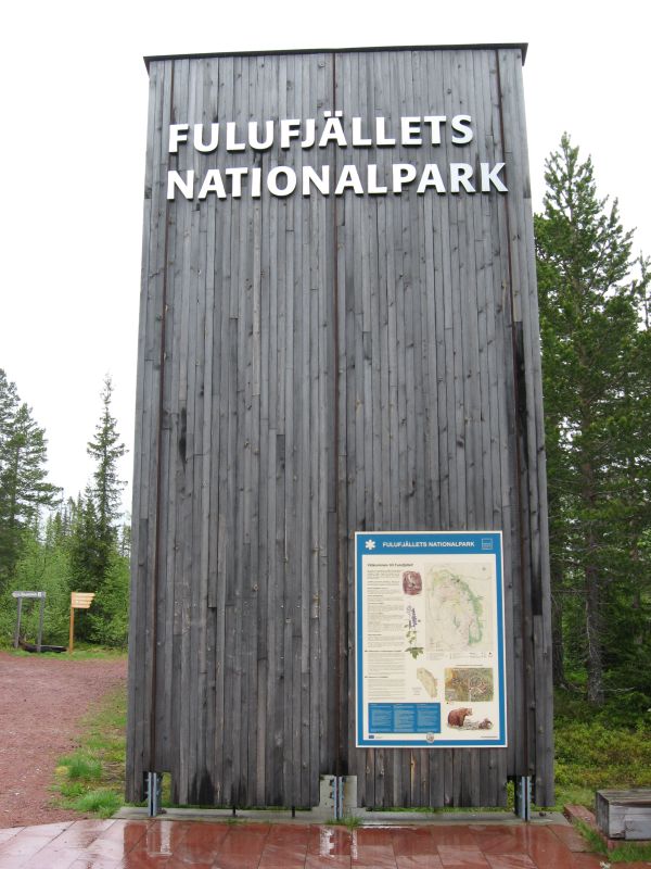
Fulufjället Earthcache
| I would be very thankful if you could write you email and
log in English. Nevertheless also Swedish email/logs are
welcome. |
 |
English version (Swedish version below): |
This earthcache would like to bring you to the Fulufjället
National Park. The Fulufjället is a national park in central
Sweden. Its total area is 385 km², located entirely within Älvdalen
Municipality in the province of Dalarna.
It is one of Sweden's most recent, inaugurated in September 2002 by
King Carl XVI Gustaf, followed by a few thousand spectators. The
park has become one of the initial PAN Parks, an international
project with the object to combine preservation with tourism.
The geography is dominated by lichen, bare mountains, and valleys
with dense ancient forest. The heaths of brush, grass and lichens
are unique in the Scandinavian mountain range, a result of the
absence of grazing reindeers.
Click for enlargement
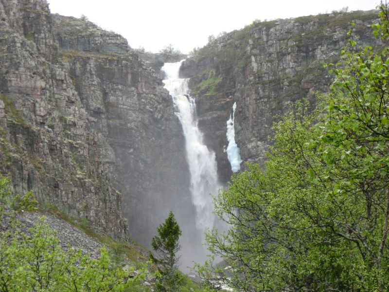
Fulufjället, who gave the National Park its name is one of the
southern Scandinavian mountains, 1,044 meters high, and consists
largely of sandstone that was formed some 900 million years ago
when the land that is now Sweden lay south of the equator.
The sand was deposited on the floor of an ocean, and traces of the
waves‘ rippling motion can still be seen on some of the
mountain‘s sandstone boulders. Mt. Fulufjället has acquired
its current form through erosion by sun, wind, water, cold and
glacial action. That process still continues, the best example
being the Njupeskär waterfall. The ongoing erosion will one day
lead to the waterfall‘s disappearance.
Although most of the mountain consists of sandstone, there are also
veins of diabase, a type of rock that gives rise to lush
vegetation. Sheilings (summer grazing camps) are often located near
veins of diabase, which stretches in a broad band along the entire
breadth of the east slope. At some places, it forms the walls of
remarkable steep cliffs.
Click for enlargement
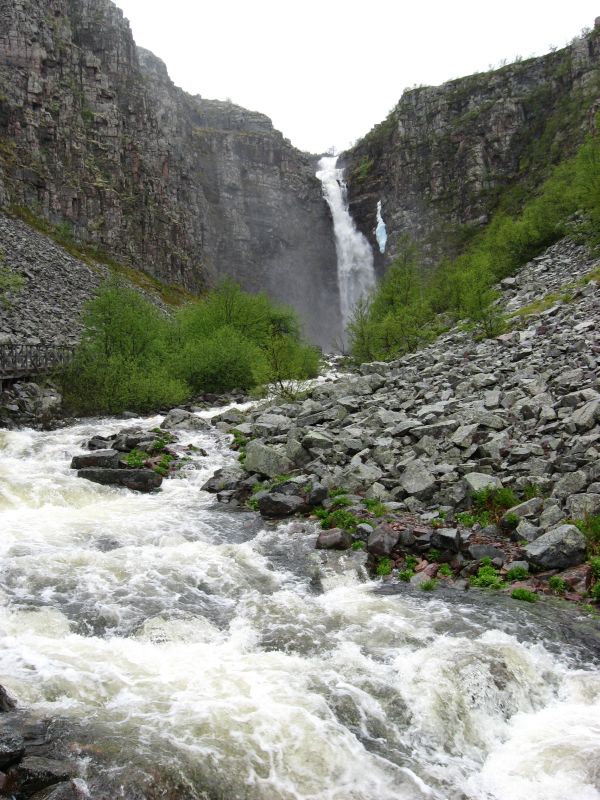
The most famous attraction of the Fulufjället National Park is
the Njupeskär waterfall. Over 900 million years ago, when the
landmass that is now the Scandinavian peninsula was located in the
southern hemisphere, water began to wear a channel in the recently
formed layer of sandstone that forms the mountain slopes. The
riverbed has gradually eroded backward to form the impressive
waterfall of today. The water runs via a large brook from the
Rörsjö lakes on the alpine plateau, over the falls into the Stora
Njupån River, then on to Mörkret where it empties into Fulan River.
At 93 meters, Njupeskär waterfall is the highest in all of
Sweden.
Click for enlargement
To
log this earthcache, perform the following
tasks:
- Park your car at N61° 38.133 E12° 43.127 and start your walk
to the waterfall. Your first stop is an information board at N61°
38.237 E12° 41.419. Use the to answer the following
questions:
- What is the longest free fall?
- Which examples of birds do the steep slopes
attract?
- Go to above coordinates. Here you stand in front
of the waterfall. Please (optional) take a photo of you or
your GPS there.
- Go
back to N61° 38.173 E12° 42.952, the Naturum Fulufjället visitor
center. A highly recommend to visit the center. In front of the
Naturum you find three big stones which are examples for the types
of stones you can find in the National Park. What stones do you see
there (the type is engraved)?
 |
Svensk version: |
Fulufjällets nationalpark är en av Sveriges nationalparker och
ligger i Särna församling i Älvdalens kommun i nordvästra Dalarna,
intill gränsen mot Trysil kommun i Norge. Den internationellt kände
svenske naturvårdaren Kai-Curry Lindahl besökte Fulufjället 1948.
"Urskogen, fallet och fjället bildar här tillsammans ett av
Dalarnas förnämsta naturområden, som inte torde ha sin like på
många håll i Sverige" skrev han som sammanfattning i boken "Natur i
Dalarna". Exakt 50 år senare, 1998, fanns Fulufjället med i
Naturvårdsverkets plan för nya nationalparker i Sverige. I
september 2002 invigdes den av kung Carl XVI Gustaf och ett par
tusen besökare.
Click for enlargement
Fulufjället tillhör Södra Skanderna och består i huvudsak av
sandsten som bildades för ungefär 900 miljoner år sedan då Sverige
låg söder om ekvatorn.
Sand avlagrades i ett hav och minnen från vågornas skvalp finns här
och där på fjällets sandstensblock i form av böljeslagsmärken.
Genom erosion och vittring av sol, vind, vatten, kyla och glaciärer
har Fulufjället skulpterats fram. Erosionen pågår fortfarande och
bästa exemplet är Njupeskärs vattenfall som är det högsta i landet
med sina 93 meter, varav 70 meter fritt fall. Den bakåtskridande
erosisonen kommer en vacker dag att resultera i att fallet
försvinner.
Click for enlargement
Även om större delen av fjället består av sandsten finns stråk
av diabas, en bergart som ger en frodigare växtlighet. Det är ofta
längs sådana stråk som fäbodarna ligger. Diabasen förekommer i ett
band längs hela östsluttningen och på flera ställen finns
uppseendeväckande skär med branta stup.
Click for enlargement
För att logga denna earthcache, utför följande
uppgifter:
- Parkera bilen vid N61° 38.133 E12° 43.127 och gå mot
vattenfallet. Det första stoppet är vid informationsskylten vid
N61° 38.237 E12° 41.419. På skylten hittar du svaren till dessa
frågor:
- Hur långt är det längsta fria
fallet?
- Vilken typ av fåglar lockar de branta
slänterna?
- Gå till de ovan givna koordinatera. Du står nu
framför vattenfallet. Var vänlig att ta ett foto av dig eller din
GPS här (valfritt).
- Gå
tillbaka till N61° 38.173 E12° 42.952, Fulufjällets Naturum
besökscenter. Jag rekommenderar starkt ett besök till Naturum.
Framför Naturum hittar du 3 stora stenar, dessa är exempel av
stenar som finns i nationalparken. Vilka stenar ser du här (sorten
är ingraverad)?