At the location of the Earth Cache, you are looking at an eroded
cliff in Hawkesbury Sandstone. This is an extensive rock formation
that can be seen here as well as at sea level on the coast. It
stretches north past Newcastle, and south past Bundanoon. It dates
back to the Triassic age, when dinosaurs first roamed the Earth
some 230,000,000 years ago. The Hawkesbury Sandstone is a quartz
rich sandstone, characteristically cross bedded and containing only
a small proportion of interbedded shale Its maximum thickness in
Sydney is some 300m, though it thins away to the west and is less
than 100m thick here. The sedimentary patterns in the Hawkesbury
Sandstone indicate that the sand was deposited by an enormous
braided river system unlike anything in Australia today. It has
been suggested that the ancient river probably extended across NSW
and Victoria and into Antarctica, which was then joined to
Australia as part of the supercontinent of Gondwana.
To log the cache, answer the following questions and
post the replies to me via my Geocaching profile page. Some will
require research away from the site. Others need information at the
site to answer.
1. What is the average thickness of the laminae?
2. Assuming the laminae were formed by a seasonal event, e.g. an
annual wet season flood, how many years are represented in a single
vertical slice through the main cross bedded layer?
3. How would you test whether the assumption in the previous
question is correct or not?
4. While the laminae are sloping, the beds themselves may not be
tilted as they may have been laid down this way rather than being
tilted after deposition. Are the beds the right way up,
significantly tilted or upside down? How can you tell?
5.Geologists think the Hawkesbury Sandstone was formed by river
action. What evidence do you see here to support or refute this
idea?
6. To the right of GZ, at the waypoint marked Q6, an unusual
erosional feature has developed in the cross bedding. Describe the
feature. Speculate on how it was formed. And how long it is likely
to survive.
7. Post the usual photo of your team at GZ. This is optional, but I
do like to see who is doing my Earthcaches. HOWEVER, do
NOT show the feature for Q6. If you do, your post
will be deleted.
Sedimentary rocks
Sedimentary rocks are rocks that have formed by the breaking
down of other rocks. There are two broad types: Clastic and
Non-Clastic. Clastic simply means that the rocks are made up of
fragments of other rocks. Non-Clastic covers rocks like Limestone,
Coal and Halite (rock salt) that are produced by chemical or
biological action. The rest of this earthcache deals with clastic
sedimentary rocks, so I will omit the word clastic for
brevity.
Sedimentary rocks are formed by the deposition of layers of
particles that have been transported from elsewhere. Thus there are
three phases in the formation of sedimentary rocks.
The first is transportation as the particles that will make up the
rock are moved from elsewhere. This transportation is usually by
water, but sometimes by wind, or even ice.
The second is deposition that occurs when there is no longer
sufficient energy to support the particles in the transporting
medium. This can happen suddenly as when a glacier melts, or a fast
moving stream enters a lake, or slowly as a stream gradually loses
energy as it approaches a plain.
The third is the lithification process that turns unconsolidated
sediment (dirt!) into rock. This involves compaction and
cementation.
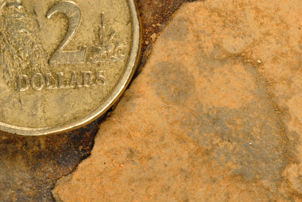
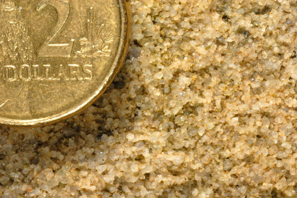
Rock Types
The type of sedimentary rock tells us a lot about the conditions
that were around at the time the sediment was first laid
down.
|
If the grains are very small (less than 0.002mm) then the rock
is called mudstone or shale This indicates slow gentle transport of
the sediment. This may indicate a large lake or floodplain. It
could also indicate deep ocean deposition, below the action of the
waves. It could also indicate a region subject to dust storms like
the loess deposits of China
Slightly larger grains (0.002 – 0.05mm) result in siltstone. This indicates slightly greater energy in
transport – a small lake, a slow, meandering river or
continental shelf in the ocean
|
Shale |
Sandstone |
Larger again (0.05 – 2mm) forms
sandstone. This indicates fairly vigorous movement
– a fast stream, such as a braided stream system, sand dunes
in a desert (usually at the finer end of the scale) or a coastal
environment.
|
| The largest grains (more than 2mm )
forms conglomerate or breccia.
This indicates an extremely vigorous transport. Breccia contains
angular blocks – It may be a scree slope at the base of an
ancient cliff, the trace of ancient glaciation, or the remains of a
volcanic explosion. In conglomerate, the pebbles are more rounded,
indicating transport over some distance – a mountain river
perhaps. Concrete is an artificial breccia if the pebbles are
angular, conglomerate if round “fancy” stones are
used.. |
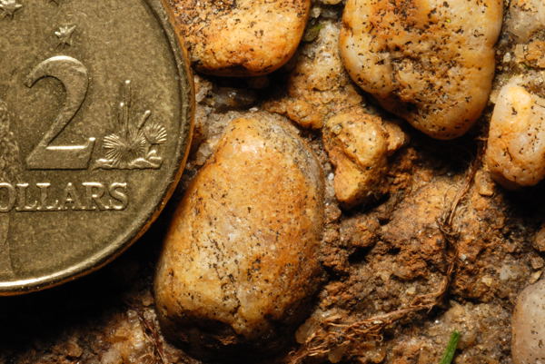
A fine conglomerate - they can be much coarser |
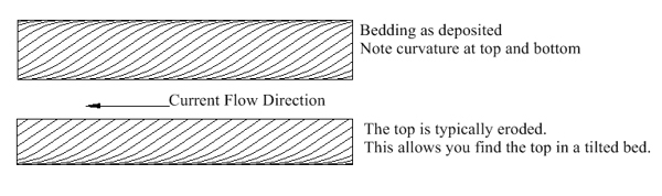
Cross Bedding
These processes form layers, called strata, of rock. These are
generally created flat, and any tilting of the strata is an
indication of later movement of the rock with folding or faulting.
However, sedimentary rock layers are not always laid down in
horizontal layers. Where the substrate is not flat, the layer of
sediment follows the underlying structure. With sand dunes, river
deltas, and sand banks, successive layers build one on the previous
one. Each lies at the angle of repose – the steepest angle at
which the sediment is stable. This is about 34° in sand, though
this can change depending on the size and shape of the grains, and
whether the sand is wet or dry. To distinguish the sloping beds
from the main horizontal beds that they form, the sloping beds are
called laminae. To determine whether a bed is cross bedded or
tilted, you need to find the next main bed above or below. The
boundary will indicate the true tilt (or lack of it)
If the laminae all face the same direction, this indicates a
consistent current – wind or water – over time. If they
alternate, this indicates a regular reversal of direction. This
could indicate a tidal zone. If they chop and change, this could
mean you are looking at a deposition regime that had frequent
random changes of direction. For example, a braided stream. You could also be looking at the bed
crosswise, rather than side on. This excellent animation shows the
formation a cross bedding and demonstrates the different view side
on to end on: http://walrus.wr.usgs.gov/seds/bedforms/animation.html
Wind Vs Water
Wind deposited (Aeolian) cross bedding tends to be larger scale
than water deposits as the latter are usually formed from ripples
and sandbanks which are rarely more than a metre high. Sand dunes,
on the other hand can be tens of metres high. An exception to this
rule is the cross bedding formed as the front of a delta extends
into a lake or sea. As the thickness of the deposit is determined
by the depth of the lake, they can be much thicker than a normal
alluvial cross bed. Aeolian grains tend to be more angular and at
the fine end of sand. They are also much more uniform in size so
the beds they form tend to be more homogenous than water formed
beds.
Graded Bedding
Sometimes a large amount of sediment being carried by a current
will enter a deeper still mass of water. The result is that the
largest grains drop to the bottom first, followed progressively by
finer and finer material. The result is a bed that has coarse
conglomerate at the bottom, progressing to fine shale at the top.
The most common cause of this is a turbidity current which is in effect an underwater
avalanche. They can also happen on a smaller scale when a flooding
river enters a large lake. These can be cyclic due to seasonal or
other factors, and lead to a series of graded beds that may or may
not also form cross bedding, with the largest grains embedded in
the finest material of the previous season’s flood.
Facies
Sedimentary Facies refers to a distinctive body of rock that
forms under a particular condition of sedimentation
At a given time, facies will change as you move horizontally. For
example, An estuary gives way to Coastal Sand dunes which in turn
give way to tidal deposits. This can be reflected vertically in a
rock sequence. For example, delta deposits can overlie the mud of a
lake bottom. as the delta progressively moves across the lake. The
delta and the lake exist at the same time side by side, but this is
recorded in the rock record as cross bedded stone overlying
horizontal shale deposits.
Bibliography and further reading
Branagan and Packham, Field Geology of New South Wales,
2nd Ed., 1970, Science Press, Marrickville Australia
Holmes, A., Principles of Physical Geology, 2nd Ed.,
1965, Thomas Nelson & Sons, London
Pickett, JW and Alder J.D., Layers of Time: The Blue Mountains and
their Geology, 1997, New South Wales Department of Mineral
Resources, Sydney
Sircombe, Keith N, Is the Gold Coast from Antarctica? Provenance
implications from detrital mineral geochronology of eastern
Australian sediments Advances in sedimentology. Australian
Sedimentologists Group Conference '97, Melbourne, 3-4 December,
1997. Geological Society of Australia.
Sydney Basin Geological map 1:500,000
Geology of the Blue Mountains
Down to Earth Geology Exhibition
Geology of the Sydney Basin
Other EarthCaches exploring aspects of the Sydney Basin
Den Fenella Track looks at how erosion and
uplift formed the classic Blue Mountains topography
The Three Sisters EarthCache looks at a famous
erosional feature
Katoomba Torbanite - DP/EC51 Permian rocks. One
of the economic uses of the rocks of the Sydney Basin
A Lockley Story The ecology of the sandstone
plateaux
Lapstone layers One of the major uplift
zones showing faults and a monocline
Dundas dig One of the many igneous
intrusions into the Sydney Basin that occured in the Triassic.
Another economic use.
The Brickpit Earthcache The topmost shale
layers in the basin and another economic use.
Hawkesbury Sandstones. This looks at the same
formation as found here. Even though you are at sea level there,
the rocks here at 500m are closer to the base of the formation
giving you some idea of the uplift involved in the Lapstone
Monocline.
The Edge of the Basin explores the unconformity
at the westernmost extremity of the Sydney Basin