(SI) Pokljuška soteska je izjemna, suha fosilna dolina, ki so jo ustvarile vode topečih se ledenikov.
PRED ZACETKOM:
Opis tega Geološkega zaklada je dolg. Prosimo, preberite ga in si zapisite naloge za vpis se pred obiskom zaklada!
NALOGE ZA VPIS OBISKA
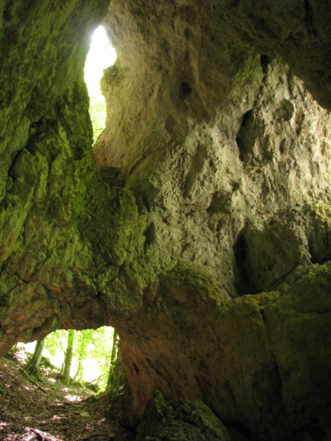
1. Obiscite Pokljusko luknjo in ugotovite koliko naravnih odprtin ima (vkljucno z vhodi in »okni«).
2. Zelo bomo veseli, ce kaksno zanimivo fotografijo z mesta zaklada prilozite svojemu vpisu (logu) obiska.
POMEMBNO!
- Preden vpisete obisk zaklada, posljite odgovore preko GC profila ali neposredno na e-naslov vane.si.geo@gmail.com. Takoj potem lahko vpisete obisk zaklada na spletu – ne potrebujete dodatnega dovoljenja. Ce ste fotografirali, prosimo, prilozite kaksno fotografijo.
- Vpisi brez ustrezne spremljajoce e-poste, ki vsebuje pravilne odgovore, bodo najprej trajno kodirani, kasneje izbrisani!
- Vpisi, ki vsebujejo odgovor bodo izbrisani!
(ENG) The Pokljuka Gorge is a unique dry ‘fossil’ valley formed by glacial melt-water.
BEFORE THE BEGINNING:
This EarthCache has a long description! Please, read it and write down logging tasks before visiting the EarthCache site!
LOGGING TASKS
1. Visit Pokljuka Hole (Pokljuska luknja) and find out how many natural openings (counting entrance, exit and windows) does it have?
2. We would be glad if you added interesting photos from the EarthCache location (under the galleries) to your log.
IMPORTANT!
- Send answers through GC profile or directly to e-mail vane.si.geo@gmail.com
before logging. After that you can log - you don't need an additional permission to log. Please, upload photos if you have taken them.
- Logs without an accompanying e-mail containing correct answers will be encrypted and later deleted!
- Logs containing the answer will be deleted!
slovensko besedilo / Slovenian text
tocke poti in dnevniki / waypoints and logs
Visit our web-site Geološki zakladi / EarthCaches
for a complete list of our EarthCaches and a lot of additional information.
(ENG) POKLJUKA GORGE
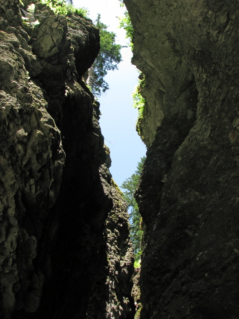
The Pokljuka gorge in the Triglav National Park is a natural attraction that extends from the area of Gorje right up to the foot of the Pokljuka plateau. The nearly 2-km-long dry valley, only a few meters wide in places, is remarkable in many respects.
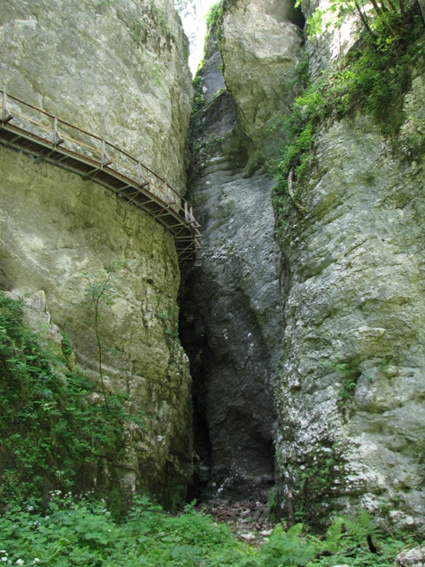
The Pokljuka gorge is well-known for its vertical, even overhanging, walls rising up to 50 m high. In places the gorge narrows down into barely passable sections. The wider sections in between are called little gardens. The gorge features several interesting geomorphological features, such as natural bridges, overhanging walls, and caves. The most famous is the Pokljuka hole, a short and passable passage.
In 1993 the Pokljuka gorge was proclaimed a natural monument.
THE HISTORY
Most locals refer to this natural attraction not as the Pokljuka Gorge but rather as the Pokljuka Hole. Why is that?
The Pokljuka Hole (Pokljuska luknja) is a shaft-like cave, which is located in the lower part of the ravine carved by the Ribscica, also named the Pokljuka Gorge (Pokljuska soteska). For centuries the cave, which is the shortest natural way from Gorje to the Pokljuka plateau, has provided an easy passage to Stara Pokljuka and across many pastures to Pokljuka.
At the time of the Kingdom of Yugoslavia, in the first half of the 20th century, the hunting lessee of surrounding forests was the King of Yugoslavia himself. His hunters and beaters set to find out where in the gorge above the Pokljuka Hole the wild game so often escaped them. After exploring the area they found that the gorge was passable, though hardly. A plan was made to open the, most interesting part of the ravine, the passage below the natural bridge between the last two widenings called vrtci (garden-plots), to visitors. In 1930 wooden bridges, called the Galleries of Prince Andrew, were built in a precipitous rock face of the ravine and since then, the Pokljuka Gorge, evidently much more than just the Pokljuka Hole, has attracted numerous visitors.
CUT BY A GLACIAL RIVER
The Pokljuka Gorge is a unique dry ‘fossil’ valley with fluvial erosion landforms indicative of the fact that the gorge was created by the water that once flowed here. At the end of the last, Würm, glaciation, climate warmed up over a relatively short period between 15,000 and 10,000 years ago, causing large quantities of ice to melt and releasing enormous quantities of water. The snouts of valley glaciers, including the terminus of the Radovna glacier in Zgornje Gorje and Krnica, or in the lower part of Pokljuka Gorge where the glacier deposited its terminal moraines and formed glacial gravel terraces, retreated rapidly up the valley. Soon, ice melt increased on the Pokljuka plateau, in particular in the area between Goreljek, Mrzli studenec and the Grajska planina alp. Glacial melt-water, transporting large amounts of gravel, flowed towards the north-east along the valley of the Ribscica stream and the Pokljuka Gorge towards the Radovna, its tremendous power deepening the river bed along the way. In the narrowest parts of the gorge, erosion activity left behind lateral channels incised in the bedrock, similar in shape to present-day ravines. The lowest tract of the Pokljuka Gorge is carved in the terraces of the Radovna glacier, which further supports the stated sequence of events.
HISTORY WRITTEN IN STONE
The Pokljuka Gorge is carved into a bed of stratified to massive Late Triassic limestone containing nodules of chert. Limestone was mostly formed in deep sea inhabited by small organisms with silica skeleton structures that were the source of chert nodules. Chert is harder than limestone and its "globs'' normally protrude from the surface. Conodonts (index fossils) were used to date the limestone layers as about 205 million years old. Conodonts are tooth-like branched or flat elements, 0.2 to 0.8 mm in size, remains of the feeding apparatuses (jaws) of an eel-like organism that became extinct at the end of the Triassic period (about 200 million years ago). Since the shape of these fossils has changed considerably over time, they can be used, along with a number of other methods, to determine with great accuracy the time when the fossil-containing rock was formed.
PATHS
The main gorge trail has been enabled by the construction of the "galleries'' across the narrowest part of the gorge. This is the direction of a mountaineering trail to the Pokljuka plateau, which leads you all along the length of the gorge. You can easily combine this trail with the one leading through Pokljuka Hole to make a circular trip (or better: number-eight-shaped, since you cross gorge using natural bridge).
The walk from the entry point to the Galleries, the most interesting part of the Pokljuka Gorge, takes about 20 minutes. It is possible to walk the entire “circle” mentioned above, in an hour and half. Be careful and safe and please note that all walkers walk at their own risk.
EARTHCACHE coordinates are placed at the widening of the gorge, under the famous galleries. There, in the middle of magnificent natural formations you will find benches to rest and information boards in Slovene and English. GPS reception in the gorge is not good, therefore just follow the marked trail to reach Earthcache. First part of the trail is sometimes damaged by water. Therefore don’t be afraid to step over a stone or two –trail is in good condition just a little bit further.
Note:
Major part of the text is taken from information boards set by Triglav National Park. Photo: vane_si;
Slovensko besedilo
Obiscite naso spletno stran Geološki zakladi / EarthCaches
za seznam vseh nasih Geoloških zakladov in mnogo dodatnih podatkov.
(SI) POKLJUSKA SOTESKA
Pokljuska soteska v Triglavskem narodnem parku je naravna znamenitost, ki se z obmocja Gorij zajeda v vznozje planote Pokljuka. Skoraj dva kilometra dolga in izjemno ozka, ponekod vintgarska suha dolina je posebnost v vec pogledih.
Znacilnost Pokljuske soteske so navpicne, ponekod celo previsne stene, visoke do 50 metrov. Na nekaterih mestih se soteska zozi v komaj prehodne tesni, drugod pa ima vecje razsiritve, ki se imenujejo vrtci. V Pokljuski soteski najdemo vrsto zanimivih geomorfoloskih oblik, kot so naravni mostovi, previsne stene in votline. Med njimi je najbolj znana Pokljuska luknja - krajsi prehoden jamski rov.
Leta 1993 so Pokljusko sotesko razglasili za naravni spomenik.
ZGODOVINA
Vecina domacinov ne govori o Pokljuski soteski, pac pa le o Pokljuski luknji. Zakaj? Pokljuska luknja je jamski rov, ki lezi v spodnjem delu soteske Ribscice (Pokljuski soteski). Skozi luknjo ze stoletja vodi pot na Staro Pokljuko in dalje preko rovtov na Pokljuko. Je najbolj naraven in najkrajsi prehod z Gorij na Pokljuko.
V casu kraljevine Jugoslavije v prvi polovici 20. stoletja je bil lovski zakupnik okoliskih gozdov sam kralj Karadjordjevic. Njegovi lovci in gonjaci so zaceli raziskovati, kje vendar v soteski nad Pokljusko luknjo jim divjad uide. Raziskali so obmocje ter odkrili, da je soteska tezko a vendarle prehodna. Zaradi zanimivosti so najbolj zanimiv del soteske - prehod pod naravnim mostom med zadnjima dvema »vrtcema« uredili za obisk. V navpicni steni so leta 1930 zgradili tehnicno zahtevne galerije, ki so jih poimenovali »galerije kraljevica Andreja«. Vse od takrat je Pokljuska soteska, ki je seveda mnogo vec kot sama Pokljuska luknja, urejena za obisk.
DELO LEDENISKE REKE
Pokljuska soteska je izjemna, suha fosilna dolina, ki s svojimi vodnimi erozijskimi oblikami dokazuje, da je delo nekdanje tekoce vode. Na koncu zadnje, würmske ledene dobe se je zaradi otoplitve podnebja v razmeroma kratkem casu pred 15.000 do 10.000 leti raztopilo veliko ledu in se sprostilo obilo vode. Cela dolinskih ledenikov, tudi radovinskega iz obmocja Zgornjih Gorij in Krnice oziroma spodnje Pokljuske soteske, kjer so njegove celne morene in ledelisko-prodne terase, so se razmeroma naglo umikala visje po dolinah. Sledilo je mocnejse topljenje ledu tudi na Pokljuki, zlasti med Goreljkom, Mrzlim Studencem in Grajsko planino. Ledeniska voda, polna proda, se je usmerila proti severovzhodu po danasnji suhi dolini Ribscice in Pokljuske soteske proti Radovni in med potjo z veliko mocjo hitro poglabljala svojo strugo. V najozjih delih soteske je erozijsko delovanje vidno v obliki vijugastih bocnih erozijskih zajed, ki spominjajo na oblike danasnjih vintgarskih sotesk. Najnizji del doline Pokljuske soteske je vrezan ze v terase radovinskega ledenika, kar dokazuje ze omenjeni vrstni red dogodkov.
ZGODOVINA ZAPISANA V KAMNU
Pokljuska soteska je vrezana v skladovnico plastovitega do masivnega zgornjetriasnega apnenca, v katerem najdemo gomolje rozenca, ki je oblika kremena. Apnenec je nastajal v globljem morju, v katerem so prebivali tudi majhni organizmi s kremenicnim skeletom, iz njih pa so nastali gomolji rozenca, ki so trsi od apnenca in ponavadi izstopajo iz povrsine. Starost apnencev je bila dolocena s fosili, imenovanimi konodonti, na 205 milijonov let. Konodonti so zobcasti vejnati ali ploscati elementi, veliki 0,2 do 0,8 mm, ki so ostanki prehranjevalnega aparata (nekaksne celjusti) jegulji podobnih organizmov, izumrlih konec triasnega obdobja (pred priblizno 200 milijoni let). Za te fosile je znacilno, da se je njihova oblika izredno hitro spreminjala, zato se da z njihovo pomocjo in z drugimi metodami, zelo natancno dolociti cas, v katerem je nastala kamnina, ki vsebuje te fosile.
POTI
Skozi sotesko vodi planinska pot na Pokljuko, ki jo je omogocila izgradnja galerij. To pot zlahka zdruzite s tisto, ki vodi skozi Pokljusko luknjo, da napravite krog, ali bolje receno pot v obliki osmice (saj vmes preko naravnega mostu preckate sotesko).
Do Galerij, najzanimivejsega dela Pokljuske soteske, je od vstopa v sotesko 20 minut hoda. Celotno sotesko pa si lahko ogledate v dobri uri, pri cemer ne pozabite na previdnost in varnost, saj je hoja po poteh Pokljuske soteske na lastno odgovornost.
Koordinate GEOLOŠKEGA ZAKLADA se nahajajo v razsiritvi soteske, pod znamenitimi galerijami. Tam boste sredi velicastno oblikovane narave nasli klopi za pocitek in vec informacijskih tabel. GPS sprejem v soteski ni najboljsi, zato do Geološkega zaklada le sledite planinski poti. Prvi del poti vcasih poskoduje voda, zato se ne ustrasite stopiti cez nekaj kamnov – visje je pot dobra.
Opomba:
Vecji del besedila je povzet z informacijskih tabel, ki jih je postavila uprava Triglavskega narodnega parka. Foto: vane_si;
tocke poti in dnevniki / waypoints and logs